
SFS 19b
Location: Teesdale-Inverleigh Road
Aust. Soil Class.:Ferric, Eutrophic, Brown CHROMOSOL
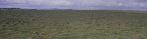
General Landscape Description: Level Plain, “outside north paddock
Site Description: Gently undulating plain tending to gently undulating rises
 SFS 19b |
Soil Profile Morphology:
| Surface Soil Ap A2 Subsoil B21 | 0-18 cm 10-30 | Darker, mostly loamy: 35 cm wavy boundary; 80% gravel 10-40 mm Light clay; darker coatings on main peds and brighter interiors than SFS19. Brown (10YR4/3) with red (10R4/8) mottles. | 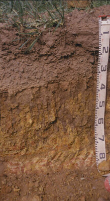 SFS 19b |
Key Profile Features:
| |||
Soil Profile Characteristics:
pH | Salinity Rating | |||
Subsoil (B21 horizon) | Moderately Acid | Low | Non-Sodic | None1 |
Horizon | Horizon Depth (cm) | pH (water) | pH (CaCl2) | EC dS/m | NaCl | Exchangeable Cations | |||
Ca | Mg | K | Na | ||||||
meq/100g | |||||||||
B21 | 40-50 | 6.0 | 5.4 | 0.20 | 0.06 | 4.7 | 7.9 | 1.1 | 1.2 |
Horizon | Horizon Depth (cm) | Exchangeable Aluminium mg/kg | Exchangeable Acidity meq/100g | Field Capacity pF2.5 | Wilting Point pF4.2 | Coarse Sand (0.2-2.0 mm) | Fine Sand (0.02-0.2 mm) | Silt (0.002-0.02 mm) | Clay (<0.002 mm) |
B21 | 40-50 | <10 | 11.0 | 40.5 | 28.5 | 6.0 | 3.3 | 2.5 | 87.5 |
Management Considerations:
Whole Profile
- Plant available water capacity (PAWC) is considered to be low/medium (estimated at 100 mm) in the upper 80 cm of this soil profile. Effective rooting depth (ERD) is restricted to 80 cm due to the basalt below this depth.
- Profile described by Richard MacEwan & Mark Imhof, June 2000.
© State of Victoria (Agriculture Victoria) 1996 - .

This work, Victorian Resources Online, is licensed under a Creative Commons Attribution 4.0 licence. You are free to re-use the work under that licence, on the condition that you credit the State of Victoria (Agriculture Victoria) as author, indicate if changes were made and comply with the other licence terms.
The licence does not apply to ‘branding’ or some ‘images or photographs’ that may be owned by third parties. We ask you to seek prior approval to use images using the VRO feedback form. Access to higher quality images can also be provided on request.
This page was last updated on .