
SFS 18
Location: Mt Gow “Big Phalaris Paddock”
Aust. Soil Class.:Calcic, Epipedal, Black VERTOSOL
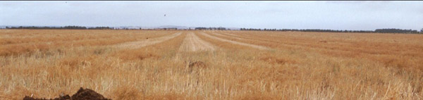
General Landscape Description: Pit excavated 20 metres north of west gate into paddock. Excavation in headland
Site Description: Canola stubble
Geology: Basalt
 SFS 18 |
Soil Profile Morphology:
| Surface Soil | 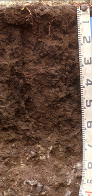 SFS 18 | ||
| Ap | 0-20 cm | Very dark greyish brown (10YR 3/2 moist) to dark greyish brown (10YR 4/2 dry); medium clay; strongly pedal, thin surface mulch of fine polyhedral peds (2-10 mm) or sometimes a thin weak crust fractured by cracks at 20 – 50 mm; coarse polyhedral and sub-angular blocky beds underlying surface mulch or crust; very firm to strong consistence; some larger cracks visible at surface; medium clay; pH 5.7; abrupt change to: | |
| Subsoil | |||
| B21t | 20-50 cm | Very dark grey (10YR 3/1 moist); heavy clay; coarse prismatic, parting to coarse polyhedral structure; main prismatic units clearly defined by deep cracking to 60+ cm depth; slickensides (>50 mm) begin at around 45 cm depth and dominate structure below 50 cm; pH 7.0; gradual change to: | |
| B22ss | 50+ cm | Very dark greyish brown (10YR 3/2 moist) to dark greyish brown (10YR 4/2 dry) with many (25%) dark yellowish brown (10YR 4/4) mottles; heavy clay; with prominent slickensides;pH 7.8; gradual change to: | |
| C | 70+ cm | Hard rounded weathering basaltic rock; pH 8.6. | |
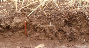 Raised beds | 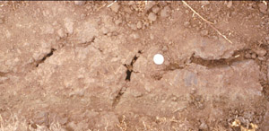 Cracking in bed farrow | 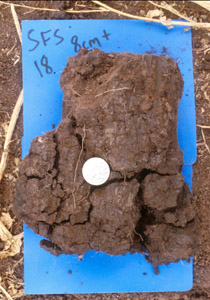 Subsoil ped |
Key Profile Features:
- Clay texture through soil profile.
- Significant cracking when profile is dry.
- Prominent slickensides in subsoil.
Soil Profile Characteristics:
pH | Salinity Rating | |||
Surface (A1 horizon) | Moderately Acid | Low-Medium | Non-Sodic | None1 |
Subsoil (B21 horizon) | Neutral | Low-Medium | Sodic | Slight-Moderate |
Deeper subsoil (at 60+ cm) | Strongly Alkaline | Strongly Sodic | Moderate |
Horizon | Horizon Depth (cm) | pH (water) | pH (CaCl2) | EC dS/m | NaCl | Exchangeable Cations | |||
Ca | Mg | K | Na | ||||||
meq/100g | |||||||||
Ap | 0-8 | 5.7 | 5.2 | 0.46 | 0.036.3 | 7.9 | 7.9 | 2.4 | 0.8 |
B21 | 15-30 | 7.0 | 6.3 | 0.43 | 0.02 | 7.4 | 13 | 2.9 | 3.6 |
B21 | 30-50 | 7.8 | 7.2 | 0.31 | 0.02 | 7.8 | 14 | 2.4 | 4.8 |
B22 | 50-65 | 8.6 | 7.8 | 0.47 | 0.03 | 8.1 | 18 | 1.9 | 6.6 |
Horizon | Horizon Depth (cm) | Exchangeable Aluminium mg/kg | Exchangeable Acidity meq/100g | Field Capacity pF2.5 | Wilting Point pF4.2 | Coarse Sand (0.2-2.0 mm) | Fine Sand (0.02-0.2 mm) | Silt (0.002-0.02 mm) | Clay (<0.002 mm) |
Ap | 0-8 | 16 | 38.0 | 22.8 | 4.0 | 28.9 | 16.5 | 41.0 | |
B21 | 15-30 | 43.7 | 27.0 | 1.7 | 25.6 | 14.0 | 51.0 | ||
B21 | 30-50 | 47.1 | 31.1 | 2.0 | 25.8 | 15.0 | 50.5 | ||
B22 | 50-65 | 52.2 | 34.9 | 2.0 | 24.3 | 16.5 | 52.5 |
Management Considerations:
Whole Profile
- Plant available water capacity (PAWC) is considered to be low/medium (estimated at 100 mm) in the upper 70 cm of this soil profile. Effective rooting depth (ERD) is restricted to 70 cm due to the basalt below this depth.
- Profile described by Richard MacEwan, May 1999.
- Soil samples collected to obtain chemistry results were not collected within the same depths that the morphology was described, so depths for chemistry and morphology do not match.
© State of Victoria (Agriculture Victoria) 1996 - .

This work, Victorian Resources Online, is licensed under a Creative Commons Attribution 4.0 licence. You are free to re-use the work under that licence, on the condition that you credit the State of Victoria (Agriculture Victoria) as author, indicate if changes were made and comply with the other licence terms.
The licence does not apply to ‘branding’ or some ‘images or photographs’ that may be owned by third parties. We ask you to seek prior approval to use images using the VRO feedback form. Access to higher quality images can also be provided on request.
This page was last updated on .