
Riversdale East Railway Cutting
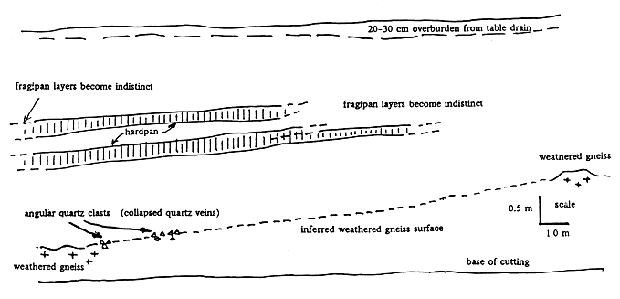
Figure 7: Stratigraphy of the southern side of the Riversdale East railway cutting.
To the east of Tallangatta at Riversdale East (Site No. 15), the railway cutting runs through a deep deposit of coarse sandy-hill slope alluvium. On the southern side of this cutting are two hardpan layers which stand out as being more resistant to erosion than the rest of the exposed sediment (Figure 7 and Photos 15 and 16). They are each about 20 cm thick and become less obvious to the east and the west of this site. At the base of the western end of the cutting, indurated gneissic saprolite is exposed and it extends westward at a level which appears to be stratigraphically continuous with the hardpan at Riversdale West. On the northern side of the Tallangatta East cutting the soil is shallower and has a single hardpan about 40 cm thick. The Riversdale East hardpans soften in water and readily slake when placed in salty water. They are therefore less indurated than the duric Tallangatta Hardpans.
The Riversdale East soil appears to be younger than the soils overlying the Tallangatta Hardpan which are generally deep yellow-brown or red-brown clayey texture-contrast soils; the Riversdale East soil is less clayey and less differentiated. These differences lead to the conclusion that the Riversdale East fragipans are younger than the Tallangatta Hardpans.
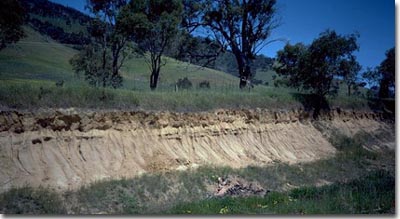 Photo 15: Riversdale East cutting showing fragipan. | |
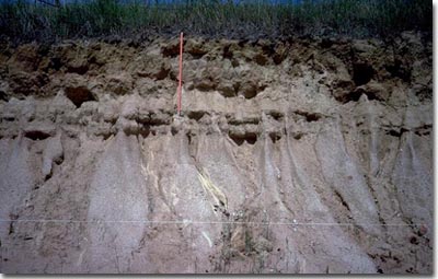 Photo 16: Riversdale East cutting showing fragipan. |
© State of Victoria (Agriculture Victoria) 1996 - .

This work, Victorian Resources Online, is licensed under a Creative Commons Attribution 4.0 licence. You are free to re-use the work under that licence, on the condition that you credit the State of Victoria (Agriculture Victoria) as author, indicate if changes were made and comply with the other licence terms.
The licence does not apply to ‘branding’ or some ‘images or photographs’ that may be owned by third parties. We ask you to seek prior approval to use images using the VRO feedback form. Access to higher quality images can also be provided on request.
This page was last updated on .