
Land Systems
- Kiewa River Catchment
- A Study of the Land in the Mount Buffalo National Park
- Land Resource Assessment in the Western part of the Shire of Towong
- A Study of the Land in the Victorian Catchment of Lake Hume
- A Study of the Land in the catchments of the upper Ovens and King Rivers
The former Soil Conservation Authority began an inventory of Victoria's lands in the 1950's. This was led by R.G Downes who saw the need to include data on land characteristics and processes, in planning land use and management. The Land Systems method was subsequently developed, with Frank Gibbons, Jim Rowan and Ken Rowe (amongst others) prominent in its application. The resultant studies identify Land Systems and their land components. These studies provide information on factors affecting production, susceptibility to processes of soil degradation, and land management.
| The Land Systems method involves an ecological approach, integrating environmental features that are often mapped singly e.g. rainfall, geology, topography, soils and indigenous vegetation. Patterns occur over time, governed by climate, geology and landform, which interact to influence the distribution of soils and vegetation. A Land System is therefore a complex mapping unit that contains a pattern of land components each of which has little variation in climate, lithology (rock type), landform, soil and indigenous vegetation. The land component can therefore be regarded as a unit of management for broad-scale uses such as dryland farming or forestry. Land System surveys have generally resulted in maps at 1:100 000 to 1:250 000 scale being produced. Many of these published studies described (but did not map) the individual components of each Land System. Consequently, a consistent statewide coverage of Land Systems (at 1:250 000 scale) was developed by Jim Rowan in 1990 and has subsequently been updated with new information. | 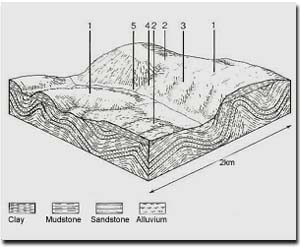 An example of a Land System and it's five land components. |
Reference
Rowan, J. (1990). Land Systems of Victoria. Department of Conservation and Environment and Land Conservation Council. Victoria, Australia.
© State of Victoria (Agriculture Victoria) 1996 - .

This work, Victorian Resources Online, is licensed under a Creative Commons Attribution 4.0 licence. You are free to re-use the work under that licence, on the condition that you credit the State of Victoria (Agriculture Victoria) as author, indicate if changes were made and comply with the other licence terms.
The licence does not apply to ‘branding’ or some ‘images or photographs’ that may be owned by third parties. We ask you to seek prior approval to use images using the VRO feedback form. Access to higher quality images can also be provided on request.
This page was last updated on .