
GRES478
Location: Castleburn
Australian Soil Classification: Melanic, Eutrophic, Red CHROMOSOL
Map Unit: Dargo (Component 1)
Previous Name: AL54
General Landscape Description: Rolling low hills.
Site description: 5% slope facing north-east on broad crest of spur
Land Use: Grazing
Native Vegetation: Grassy woodland
Geology: Silurian granite
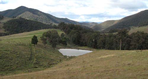
Rolling low hills of the Dargo Map unit near Castleburn. The steep hills in the background are mapped as Talbotville
Soil Profile Morphology:
Surface Soil
| A1 | 0 – 10 cm | Dark brown (10YR3/3); sandy loam; weak crumb structure; earthy fabric; soft when dry; diffuse change to: | 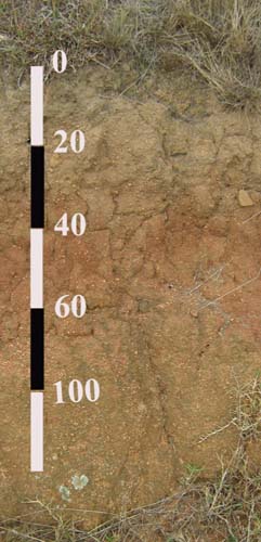 Photo of soil profile similar to the one described in this report |
| A2 | 10 – 25 cm | Brown (10YR4/3); sandy loam; apedal; hard when dry; porous; clear change to: | |
| Subsoil | |||
| B2 | 25 – 50 cm | Dark red (2.5YR3/6); sandy clay; weak fine angular blocky structure; smooth ped fabric; very firm when moist; common weathered feldspar and mica; clear change to: | |
| C | 50 – 120+ cm | Yellowish red (5YR5/6); sandy clay loam; apedal; firm when moist passing to weathering granite. |
Chemical and Physical Analysis:
Horizon | Horizon Depth (cm) | pH (water) | EC dS/m | Organic Carbon % | Total Nitrogen % | Free Fe2O3 % w/w | Exchangeable Cations | Coarse Sand (0.2-2.0 mm) % | Fine Sand (0.02-0.2 mm) % | Silt (0.002-0.02 mm) % | Clay (<0.002 mm) % | |||
Ca | Mg | K | Na | |||||||||||
meq/100g | ||||||||||||||
A1 | 0-10 | 6.1 | <0.05 | 1.8 | 0.15 | 1.0 | 4.2 | 0.8 | 0.4 | <0.1 | 43 | 36 | 13 | 7 |
A2 | 20-25 | 6.2 | <0.05 | 0.19 | 0.03 | 1.9 | 3.6 | 1.7 | 0.2 | 0.2 | 37 | 32 | 17 | 13 |
B2 | 30-50 | 6.6 | <0.05 | 3.3 | 7.5 | 3.3 | 0.3 | 0.5 | 31 | 25 | 15 | 29 | ||
C | 60-90 | 7.2 | <0.05 | 2.7 | 8.9 | 3.1 | 0.3 | 0.6 | 40 | 31 | 9 | 19 | ||
Profile Described By: J.M. Aldrick, 1978.
© State of Victoria (Agriculture Victoria) 1996 - .

This work, Victorian Resources Online, is licensed under a Creative Commons Attribution 4.0 licence. You are free to re-use the work under that licence, on the condition that you credit the State of Victoria (Agriculture Victoria) as author, indicate if changes were made and comply with the other licence terms.
The licence does not apply to ‘branding’ or some ‘images or photographs’ that may be owned by third parties. We ask you to seek prior approval to use images using the VRO feedback form. Access to higher quality images can also be provided on request.
This page was last updated on .