
EGW83
Location: Wulgulmerang
Australian Soil Classification: Haplic, Eutrophic, Brown CHROMOSOL (Stony)
Map Unit: Gelantipy (Component 1)
Previous Site Name: EG83
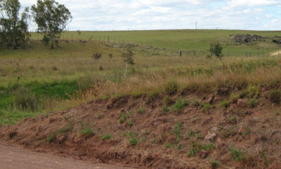
General Landscape Description: Plateau
Site Description: Lower slope, <2% slope (Roadside exposure)
Land Use: Grazing
Native Vegetation: Montane grassy woodland
Geology: Tertiary basalt
Soil Profile Morphology:
| Surface soil | 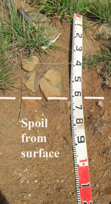 | ||
| A1 | 0 – 30 cm | Brown (7.5YR3/2); silty clay loam; strong coarse polyhedral structure; firm consistence moderately moist; many subrounded basalt stones; pH 6.3; clear change to: | |
| Subsoil | |||
| B2 | 30 - 55+cm | Brown (7.5YR4/2); medium clay; moderate to strong medium prismatic structure; very firm consistence moderately moist; abundant subrounded basalt stones; pH 6.7. |
Key Profile Features:
- Moderate texture contrast between the surface and subsoil horizons.
- Basalt stones throughout the profile, although other roadside cuttings show this to be a variable feature.
Soil Profile Characteristics:
| - | pH | Salinity | ||
Surface soil (A1 horizon) | Slightly acid | Very low | Non sodic | None |
Subsoil (B2 horizon) | Slightly acid | Very low | Non sodic | None |
Chemical and Physical Analysis:
Horizon | Horizon Depth (cm) | pH (water) | pH (CaCl2) | EC dS/m | Organic Carbon % | Total Nitrogen % | Free Fe2O3 % w/w | Exchangeable Aluminium ppm | Exchangeable Acididty meq/100g | Exchangeable Cations | Coarse Sand (0.2-2.0 mm) % | Fine Sand (0.02-0.2 mm) % | Silt (0.002-0.02 mm) % | Clay (<0.002 mm) % | Field Capacity % w/w | Wilting Point % w/w | |||
Ca | Mg | K | Na | ||||||||||||||||
meq/100g | |||||||||||||||||||
A1 | 0-30 | 6.3 | 5.7 | 0.06 | 2.3 | 0.2 | 2.1 | <1 | 9.2 | 11 | 6.4 | 0.34 | 0.29 | 11 | 34 | 26 | 25 | 41 | 17.9 |
B2 | 30-55 | 6.7 | 5.9 | 0.11 | 2.4 | 10.0 | 17 | 13 | 0.35 | 0.29 | 5 | 26 | 21 | 42 | 47.9 | 29.3 | |||
Management Considerations
Whole profile
- The profile is slightly acid throughout.
- These soils are well drained due their strongly developed structure.
- Plant available water capacity is considered to be low, estimated at 45 mm based on the laboratory data, and taking into consideration the presence of basalt stones.
Surface (A) horizons
- The soil has low organic matter content. Organic matter will be better maintained under rotational grazing, which enables stronger pasture recovery, rather than set stocking.
- The nutrient holding capacity of the soil is high (based on the sum of the exchangeable basic cations).
- Potassium levels are low to moderate.
Subsoil (B) horizon
- The friable nature of the subsoil allows deep penetration of plant roots until the basalt rock is encountered.
- The friable nature of the subsoil and the presence of rock will lead to problems with sealing of earth dams.
Profile Described By: David Rees and Grant Boyle, 2000.
© State of Victoria (Agriculture Victoria) 1996 - .

This work, Victorian Resources Online, is licensed under a Creative Commons Attribution 4.0 licence. You are free to re-use the work under that licence, on the condition that you credit the State of Victoria (Agriculture Victoria) as author, indicate if changes were made and comply with the other licence terms.
The licence does not apply to ‘branding’ or some ‘images or photographs’ that may be owned by third parties. We ask you to seek prior approval to use images using the VRO feedback form. Access to higher quality images can also be provided on request.
This page was last updated on .