
EGW40
Location: Gelantipy
Australian Soil Classification: Acidic, Regolithic, Bleached-Orthic TENOSOL
Map Unit: Wulgulmerang (Component 1)
Previous Site Name: EG40
General Landscape Description: Undulating rises
Site description: Upper slope of low hill, 4% slope, auger sample on roadside
Native Vegetation: Montane dry woodland
Geology: Devonian acid volcanics (Snowy River Volcanics)
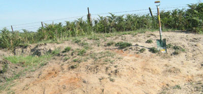
Soil exposed adjoining road near site
Soil Profile Morphology:
Surface Soil
| A1 | 0 – 10 cm | Weak red (2.5YR4/2); sandy loam; weak angular blocky structure; very weak consistence moist, pH 6.2; clear change to: | |
| A2 | 10 – 50 cm | Light brownish grey (10YR6/4) mottled with pale yellow (2.5Y8/4); coarse sandy loam; single grain; very weak consistence dry; few small gravel; pH 5.0; gradual change to: | |
| A3 | 50 – 70+ cm | Yellowish brown (10YR5/6), pale yellow dry; coarse loamy sand (2.5Y7/2); massive; weak consistence dry; common subangular small gravel; pH 5.0. | |
Key Profile Features:
- Very sandy and no texture change throughout the profile.
Soil Profile Characteristics:
- | pH | Salinity | ||
Surface soil (A1 horizon) | Slightly Acid | Very Low | Non-sodic | Minimal Aggregation |
Subsoil (A2 horizon) | Strongly Acid | Very Low | Non-sodic | Minimal Aggregation |
Deeper subsoil (50-70 cm) | Strongly Acid | Very Low | Non-sodic | Minimal Aggregation |
Chemical and Physical Analysis:
Horizon | Horizon Depth (cm) | pH (water) | pH (CaCl2) | EC dS/m | Organic Carbon % | Total Nitrogen % | Exchangeable Aluminium ppm | Exchangeable Acididty meq/100g | Exchangeable Cations | Coarse Sand (0.2-2.0 mm) % | Fine Sand (0.02-0.2 mm) % | Silt (0.002-0.02 mm) % | Clay (<0.002 mm) % | Field Capacity % w/w | Wilting Point % w/w | |||
Ca | Mg | K | Na | |||||||||||||||
meq/100g | ||||||||||||||||||
A1 | 0-10 | 6.2 | 5.7 | 0.07 | 1.4 | 0.1 | <1 | 4.8 | 5.5 | 1.0 | 0.31 | 0.05 | 38 | 31 | 18 | 9 | 23.9 | 6.0 |
A2 | 10-50 | 5.0 | 4.4 | <0.05 | 83 | 4.9 | 0.94 | 0.26 | 0.16 | 0.06 | 33 | 36 | 22 | 8 | 18.2 | 3.6 | ||
A3 | 50-70 | 5.0 | 4.4 | 0.05 | 88 | 3.7 | 0.81 | 0.42 | 0.18 | 0.07 | 38 | 31 | 22 | 10 | 17.5 | 4.4 | ||
Management Considerations
Whole profile
- Apart from the immediate surface soil, the soil is strongly acid throughout. The calcium levels and the pH of the surface soil indicate lime has possibly been applied in the past, but further evaluation may be needed in the future.
- The plant available water content is low, estimated at 53 mm for a rooting depth of 70 cm. This figure will depend on the degree to which the roots can penetrate the massive A2 and A3 horizon, and overcome the strongly acid conditions.
- The organic matter content of the soil is very low. As the soil was sampled by auger on the road reserve, this may not reflect the conditions in the paddock.
- The low wilting point of the surface horizons indicates plants will be able to use light rains when the soil is dry. Due to the low water storage capacity of the soil, plants will suffer water stress unless further rains occur.
- The nutrient holding capacity of the soil is low (based on the sum of the exchangeable cations).
- Potassium levels are bordering on deficiency level, but no response would be expected at this stage.
- Strongly acidic subsurface horizon with moderate to high exchangeable aluminium levels may restrict growth of aluminium sensitive species such as lucerne.
- The hard setting nature of the A2 and A3 horizons, together with the strong acidity of the profile may impede root penetration.
Profile Described By: David Rees and Grant Boyle, 2000.
© State of Victoria (Agriculture Victoria) 1996 - .

This work, Victorian Resources Online, is licensed under a Creative Commons Attribution 4.0 licence. You are free to re-use the work under that licence, on the condition that you credit the State of Victoria (Agriculture Victoria) as author, indicate if changes were made and comply with the other licence terms.
The licence does not apply to ‘branding’ or some ‘images or photographs’ that may be owned by third parties. We ask you to seek prior approval to use images using the VRO feedback form. Access to higher quality images can also be provided on request.
This page was last updated on .