
EGW38
Location: Butchers Ridge
Australian Soil Classification: Bleached, Eutrophic, Yellow DERMOSOL (Stony)
Map Unit: Carrabungla
Previous Site Name: EG38
General Landscape Description: Steep hills
Site Description: Road exposure on lower hill-slope, NNW aspect 42% slope, 40% rock outcrop
Land Use: Partially cleared
Geology: Devonian Volcanics (Snowy River Volcanics)
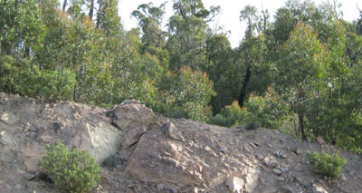
Road exposure near Seldom Seen, showing the rocky nature of the soils on the Carrabungla Map Unit.
Soil Profile Morphology:
| Surface soil | 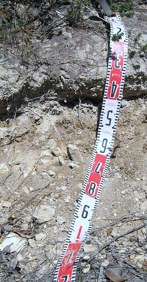 Soil profile typical of the Carrabungla Map Unit | ||
| A1 | 0 – 20 cm | Greyish brown; sandy loam; weak consistence moist; variable amounts of angular tabular rock mostly up to 200 mm; gradual change to: | |
| Subsoil | |||
| B1 | 20 – 40 cm | Pale brown; sandy clay loam; firm consistence moist; increasing amounts of angular tabular parent rock; gradual change to: | |
| B2 | 40 – 70 +cm | Light yellowish brown; light clay; firm consistence moist; abundant angular tabular stones passing to parent rock. | |
Key Profile Features:
- Weak texture contrast between the surface soils and subsoils.
- Shallow and rocky nature of the soil will restrict plant growth.
Soil Profile Characteristics:
- | pH | Salinity | ||
Subsoil (B1 horizon) | Slightly acid | Very low | Non sodic | None |
Deeper subsoil (40-70 cm) | Slightly acid | Very low | Non sodic | None |
Chemical and Physical Analysis:
Horizon | Horizon Depth (cm) | pH (water) | pH (CaCl2) | EC dS/m | Exchangeable Aluminium ppm | Exchangeable Acididty meq/100g | Exchangeable Cations | Coarse Sand (0.2-2.0 mm) % | Fine Sand (0.02-0.2 mm) % | Silt (0.002-0.02 mm) % | Clay (<0.002 mm) % | Field Capacity % w/w | Wilting Point % w/w | |||
Ca | Mg | K | Na | |||||||||||||
meq/100g | ||||||||||||||||
B1 | 20-40 | 6.3 | 5.6 | 0.05 | <1 | 5.1 | 4.3 | 1.1 | 0.27 | 0.06 | 34 | 29 | 19 | 18 | 24.2 | 7.2 |
B2 | 40-70 | 6.3 | 5.6 | 0.05 | <1 | 6.1 | 4.5 | 2.1 | 0.43 | 0.1 | 28 | 24 | 14 | 33 | 25.4 | 10.2 |
Management Considerations
Whole profile
- The profile is slightly acid throughout.
- If the soil was under pasture with an effective rooting depth of 70 cm the plant available water capacity is considered to be low; estimated at 47 mm due to its stony nature.
Surface (A) horizons
Although no surface sample was taken, it would be safe to assume:
- The low wilting point of the sub-surface horizon indicates if pasture species are grown, they will be able to use light rains when the soil is dry. Due to the low water storage capacity of the soil, plants will suffer water stress unless further rains occur.
- The soils are slightly acidic and, under pasture, would show little if any response to lime.
- The nutrient holding capacity of the soil is very low, based on the sum of the exchangeable basic cations.
- Potassium levels are deficient and a response to potassium fertilisers would be expected if the soils were under pasture.
Profile Described By: David Rees and Grant Boyle, 2000.
© State of Victoria (Agriculture Victoria) 1996 - .

This work, Victorian Resources Online, is licensed under a Creative Commons Attribution 4.0 licence. You are free to re-use the work under that licence, on the condition that you credit the State of Victoria (Agriculture Victoria) as author, indicate if changes were made and comply with the other licence terms.
The licence does not apply to ‘branding’ or some ‘images or photographs’ that may be owned by third parties. We ask you to seek prior approval to use images using the VRO feedback form. Access to higher quality images can also be provided on request.
This page was last updated on .