
EGS262
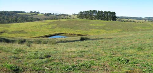
Location: Clifton Creek
Australian Soil Classification: Sodic, Dystrophic, Yellow CHROMOSOL
Map Unit: Tambo (Component 2)
Previous Site Name: EG262
General Landscape Description: Undulating to rolling low hills.
Site Description: Mid-slope, north aspect, 10 % slope
Land Use: Grazing
Native Vegetation: Shrubby dry forest
Geology: Ordovician sediments
Soil Profile Morphology:
Surface Soil
| A1 | 0 – 5 cm | Dark brown (10YR3/2); loam; weak fine subangular blocky structure; firm dry; abrupt change to: | 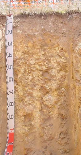 EG262 Profile |
| Subsoil | |||
| B21 | 5 – 20 cm | Brown (7.5YR4/2), light brown (7.5YR6/3 dry); medium clay (subplastic); moderate coarse prismaticstructure; firm dry; few (<10%) angular medium pebbles (<20 mm); clear change to: | |
| B22* | 20 – 30 cm | Brown (7.5YR4/2), few coarse reddish yellow (7.5YR6/6) mottles; light clay; moderate coarse prismatic structure; common (10-20%) angular stones (200-600 mm); clear change to: | |
| C | 30 -70 cm | Yellowish brown (10YR5/4); light clay; massive; abundant (>90%) angular soft rock. | |
| *This horizon is discontinuous | |||
Key Profile Features:
- Shallow depth of surface soil.
- Marked increase in soil texture between the A1 and B21 horizon.
- Shallow depth to soft decomposing rock.
Soil Profile Characteristics:
Surface soil | Strongly Acid | Non-Sodic | None |
Subsoil (B22 horizon) | Moderately Acid | Sodic | None1 |
Deep subsoil (C horizon) | Slightly Alkaline | Non-Sodic | Moderate2 |
Chemical and Physical Analysis:
Horizon | Horizon Depth (cm) | pH (water) | pH CaCl2 | CE dS/m | Organic Carbon % | Total Nitrogen % | Exch. Al | Exch. Acididty meq/100g | Exchangeable Cations | Coarse Sand (0.2-2.0 mm) % | Fine Sand (0.02-0.2 mm) % | Silt (0.002-0.02 mm) % | Clay (<0.002 mm) % | Field cap. % w/w | Wilt. point % w/w | |||
Ca | Mg | K | Na | |||||||||||||||
meq/100g | ||||||||||||||||||
A1 | 0-5 | 5.1 | 4.4 | 5.1 | 8.3 | 0.6 | 140 | 21 | 3.2 | 2.1 | 0.3 | 0.2 | 21 | 29 | 20 | 14 | 36.4 | 17.4 |
B21 | 5-20 | 5.7 | 4.7 | 5.7 | 2.3 | 0.11 | 100 | 12 | 0.3 | 1.2 | <0.1 | 0.4 | 18 | 28 | 7 | 41 | 26.9 | 10.3 |
B22 | 20-30 | 6.7 | 5.3 | 6.7 | 13 | 6.1 | 0.1 | 2.6 | 0.1 | 0.6 | 17 | 26 | 28 | 25 | 24.1 | 10.8 | ||
C | 30-70 | 7.6 | 6.4 | 7.6 | <5 | 1.7 | <0.1 | 3.4 | <0.1 | 0.3 | 19 | 18 | 38 | 23 | 21 | 10.3 | ||
Management Considerations
Whole profile
- On the assumption the roots can extract the water in the top 25 cm of the soil, the plant available water capacity is estimated at 38 mm. The high amounts of organic matter in this surface soil have added to the soil’s ability to retain water.
Surface (A) horizons
- The surface soil is strongly acidic but in the subsoil it is moderately acidic. Lime is unlikely to show any economic benefit.
- Potassium is deficient and a response to potassium fertiliser is likely. This would particularly apply if the pasture was removed and baled.
- The nutrient holding capacity of the soil is low (based on the sum of the basic cations) and the depth of surface soil is shallow.
Subsoil (B) horizons
- Based on the sum of the basic cations, the subsoil has a very low nutrient holding capacity.
- The subsoil is non-sodic and only slightly dispersive. Given the presence of increasing amounts of rock down the profile, gully and tunnel erosion is unlikely.
Profile Described By: Ian Sargeant (2011).
© State of Victoria (Agriculture Victoria) 1996 - .

This work, Victorian Resources Online, is licensed under a Creative Commons Attribution 4.0 licence. You are free to re-use the work under that licence, on the condition that you credit the State of Victoria (Agriculture Victoria) as author, indicate if changes were made and comply with the other licence terms.
The licence does not apply to ‘branding’ or some ‘images or photographs’ that may be owned by third parties. We ask you to seek prior approval to use images using the VRO feedback form. Access to higher quality images can also be provided on request.
This page was last updated on .