
EGS261
Location: Bruthen
Australian Soil Classification: Melacic, Eutrophic, Brown DERMOSOL
Map Unit: Tambo (Component 1)
Previous Site Name: EG261
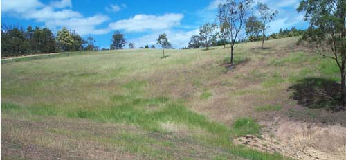
General Landscape Description: Rolling to steep low hills.
Site Description: Upper slope
Land Use: Grazing on annual pasture
Native Vegetation: Valley dry forest
Geology: Ordovician sediments
Soil Profile Morphology:
Surface Soil
| A11 | 0 – 12 cm | Dark yellowish brown; fine sandy clay loam; few (10%) small angular pebbles (<20 mm); clear and wavy change to: | 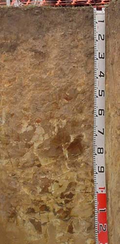 EG261 Profile |
| A12 | 12 – 35 cm | Yellowish brown; fine sandy clay loam (heavy); common (10-20%) angular pebbles (<60 mm) increasing with depth; gradual change to: | |
| A13 | 35 – 60 cm | Light brown; fine sandy clay loam (heavy); many (20-50%) angular pebbles and cobbles (<200 mm) increasing in size and amounts with depth; passing to: | |
Subsoil | |||
| R | 60+ cm | Weak rock becoming stronger with depth. |
Key Profile Features:
- Uniform textures to at least 60 cm.
Soil Profile Characteristics:
- | |||
Surface soil (A11 horizon) | Strongly Acid | Non-Sodic | None |
Subsurface (A12 horizon) | Strongly Acid | Non-Sodic | None1 |
Deeper subsoil (35 – 60 cm) | Strongly Acid | Non-Sodic | None2 |
Chemical and Physical Analysis:
Horizon | Horizon Depth (cm) | pH (water) | pH CaCl2 | CE dS/m | Organic Carbon % | Total Nitrogen % | Exch. Al | Exch. Acididty meq/100g | Exchangeable Cations | Coarse Sand (0.2-2.0 mm) % | Fine Sand (0.02-0.2 mm) % | Silt (0.002-0.02 mm) % | Clay (<0.002 mm) % | Field cap. % w/w | Wilt. point % w/w | |||
Ca | Mg | K | Na | |||||||||||||||
meq/100g | ||||||||||||||||||
A11 | 0-12 | 5.4 | 4.7 | 0.07 | 5.7 | 0.35 | 71 | 17 | 7.1 | 1.8 | 0.4 | <0.1 | 16 | 30 | 26 | 17 | 37.6 | 12.1 |
A12 | 12-35 | 5.2 | 4.4 | <0.05 | 200 | 13 | 1.4 | 1.3 | 0.3 | <0.1 | 15 | 32 | 31 | 18 | 27.1 | 8.6 | ||
A13 | 35-60 | 5.3 | 4.4 | <0.05 | 190 | 9.1 | 0.9 | 1.8 | 0.2 | <0.1 | 17 | 33 | 28 | 21 | 22.1 | 8.3 | ||
Management Considerations
Whole profile
- The brown colours throughout and lack of texture contrast indicate the profile is well drained internally.
- The soil texture is almost uniform throughout.
Surface (A11) horizon
- The soil has a high organic matter content conferring good structural stability.
- The nutrient holding capacity of the soil is moderate (based on the sum of exchangeable cations).
- The potassium levels are marginal but the soil is unlikely to show a response to potassium fertilisers at this stage.
Subsurface soils
- The presence of increasing amounts of rock in the subsoil is likely to restrict root development.
Profile Described By: Ian Sargeant (2011).
© State of Victoria (Agriculture Victoria) 1996 - .

This work, Victorian Resources Online, is licensed under a Creative Commons Attribution 4.0 licence. You are free to re-use the work under that licence, on the condition that you credit the State of Victoria (Agriculture Victoria) as author, indicate if changes were made and comply with the other licence terms.
The licence does not apply to ‘branding’ or some ‘images or photographs’ that may be owned by third parties. We ask you to seek prior approval to use images using the VRO feedback form. Access to higher quality images can also be provided on request.
This page was last updated on .