
EGS251
Location: Tostaree
Australian Soil Classification: Brown CHROMOSOL or KUROSOL (depends on pH)
Great Soil Group: soloth
Map Unit: Waygara
Previous Site Name: EG251, CFTT02
General Landscape Description: Undulating plain.
Site description: 6% slope to south.
Land Use: Hardwood plantation.
Native vegetation: Lowland forest.
Geology: Tertiary sediments
Soil Profile Morphology:
Surface Soil
| A1 | 0 – 8 cm | Very dark greyish brown (10YR3/2); loamy fine sand; weak fine granular structure; very weak consistence moderately moist; clear and wavy transition to: | 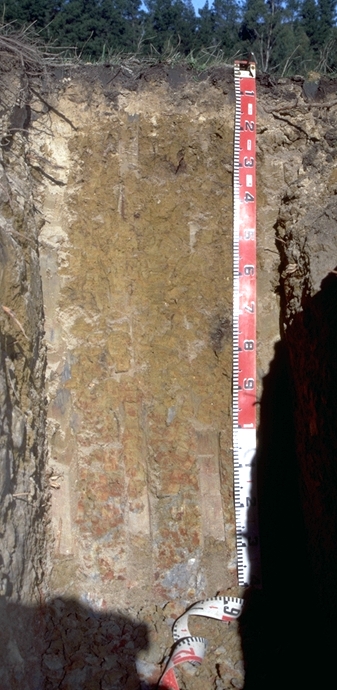 EG251 Profile (also called CFTTO2) |
| A2 | 8 – 15/20 cm | Pale brown (10YR6/3); loamy fine sand; massive; very weak consistence dry; sharp and wavy transition to: | |
| Subsoil | |||
| B21 | 15/20-85 cm | Yellowish brown (10YR5/4 and 10YR5/6); light medium clay; moderate very coarse angular blocky structure, parting to moderate medium angular blocky structure; strong consistence moist; diffuse and smooth transition to: | |
| B22 | 85-120 cm | Brown (10YR5/3) with many very coarse prominent red (2.5YR4/6) mottles; light medium clay; moderate very coarse angular blocky structure, parting to moderate medium angular blocky structure; strong consistence moist; diffuse and smooth transition to: | |
| C | 120-140 cm | Light grey (10YR6/1), with many very coarse, prominent dark red (2.5YR3/6) and yellowish brown (10YR5/6) mottles; sandy medium clay; moderate very coarse angular blocky, parting to moderate coarse angular blocky structure; some fine gravelly sub-rounded quartz; strong consistence moist. |
Profile Described by: Ian Sargeant and Justin Wong (June 1999).
© State of Victoria (Agriculture Victoria) 1996 - .

This work, Victorian Resources Online, is licensed under a Creative Commons Attribution 4.0 licence. You are free to re-use the work under that licence, on the condition that you credit the State of Victoria (Agriculture Victoria) as author, indicate if changes were made and comply with the other licence terms.
The licence does not apply to ‘branding’ or some ‘images or photographs’ that may be owned by third parties. We ask you to seek prior approval to use images using the VRO feedback form. Access to higher quality images can also be provided on request.
This page was last updated on .