
EGS248
Location: Tostaree
Australian Soil Classification: Bleached-Mottled, Eutrophic, Brown CHROMOSOL (Thick sandy surface horizons)
Northcote Factual Key: Dy5.41
Great Soil Group: soloth
Map Unit: Waygara
Previous Site Name: EG248, CFTT03
General Landscape Description: Undulating plain.
Site description: 3% slope to east
Land Use: Plantation forest
Native Vegetation: Lowland forest
Geology: Tertiary sediments
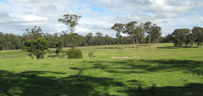
Landscape typical of this map unit near Newmerella
Soil Profile Morphology:
Surface Soil
| A1 | 0 – 15 cm | Very dark greyish brown (10YR3/2); loamy fine sand; weak fine granular structure; very weak consistence moist; pH 5.3; clear and wavy transition to: | 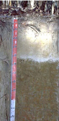 EG248 Profile |
| A2 | 15 – 55 cm | Light yellowish brown (10YR6/4), conspicuously bleached (10YR7/3d); loamy fine sand; massive; very weak consistence dry; pH 5.4; sharp and wavy transition to: | |
| Subsoil | |||
| B21 | 55 – 100 cm | Dark yellowish brown (10YR4/6) with common, coarse, distinct yellowish red (5YR4/6) mottles; light medium clay; moderate coarse sub-angular blocky, parting to moderate medium polyhedral structure; very firm consistence moist; pH 5.5; diffuse and smooth change to: | |
| B22 | 100 – 140 cm | Red (2.5YR4/6) with many, coarse, prominent dark yellowish brown (10YR4/6) and light brownish grey (10YR6/2) mottles; mottling becomes more pronounced with depth; light medium clay; strong medium prismatic, parting to strong medium polyhedral structure; strong consistence moist; pH 5.5. |
Key Profile Features:
- Very strong texture contrast between the sandy surface (A) horizons and the clay subsoil (B21) horizon.
- Conspicuously bleached A2 horizon.
Soil Profile Characteristics:
- | pH | Salinity | ||
Surface soil (A1 horizon) | Strongly acid | Very low | Non-Sodic | None |
Subsoil (B21 horizon) | Strongly acid | Very low | Non-Sodic | None |
Deeper Subsoil (at 1 m) | Strongly acid | Very low | Non-Sodic | None |
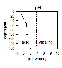 | 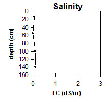 | 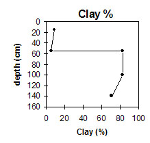 | 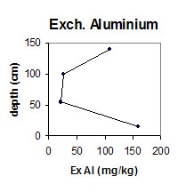 |
The soil profile is strongly acid throughout. | The level of soluble salts is very low throughout the soil profile. | The level of exchangeable aluminium is high in the strongly acid surface soil, and becomes lower at depth. | The clay content increases significantly at the A/B horizon interface. |
Horizon | Horizon Depth (cm) | pH (water) | pH (CaCl2) | EC 1:5 | Exchangeable Cations | |||
Ca | Mg | K | Na | |||||
meq/100g | ||||||||
A1 | 0-15 | 5.3 | 4.3 | 0.08 | 0.81 | 0.93 | 0.18 | 0.19 |
A2 | 15-55 | 5.4 | 4.6 | <0.05 | 0.33 | 0.19 | 0.08 | 0.06 |
B21 | 55-100 | 5.5 | 4.9 | 0.11 | 1.4 | 11 | 0.13 | 1.1 |
B22 | 100-140 | 5.5 | 4.7 | <0.05 | 0.1 | 0.65 | <0.05 | 0.08 |
Horizon | Horizon Depth (cm) | Exchangeable Aluminium mg/kg | Exchangeable Acidity meq/100g | Field Capacity pF 2.5 | Wilting Point pF 4.2 | Coarse Sand (0.2-2.0 mm) | Fine Sand (0.02-0.2 mm) | Silt (0.002-0.02 mm) | Clay (<0.002 mm) |
A1 | 0-15 | 160 | 16 | 17.9 | 8.4 | 28 | 44 | 13 | 9 |
A2 | 15-55 | 22 | 2.3 | 15.5 | 2.3 | 32 | 48 | 15 | 6 |
B21 | 55-100 | 27 | 13 | 49.1 | 31 | 3 | 9 | 4 | 83 |
B22 | 100-140 | 25 | 3 | 14.3 | 3.4 | 1 | 20 | 7 | 71 |
Management Considerations:
- The subsoil has low calcium and a low calcium to magnesium ratio. Calcium deficiencies may occur as a result.
- The soil profile is strongly acid throughout. The availability of some elements (eg copper and molybdenum) may be low as a result. Aluminium toxicity can be a problem in strongly acid soils and the level here is likely to affect phosphorus availability. The use of test strips to see whether the addition of lime is going to be economical is recommended if the soil is to be used for pasture.
- Potassium is low and deficient and a response to potassium fertilizer would be expected.
© State of Victoria (Agriculture Victoria) 1996 - .

This work, Victorian Resources Online, is licensed under a Creative Commons Attribution 4.0 licence. You are free to re-use the work under that licence, on the condition that you credit the State of Victoria (Agriculture Victoria) as author, indicate if changes were made and comply with the other licence terms.
The licence does not apply to ‘branding’ or some ‘images or photographs’ that may be owned by third parties. We ask you to seek prior approval to use images using the VRO feedback form. Access to higher quality images can also be provided on request.
This page was last updated on .