
EGS236
Location: Bendoc North
Australian Soil Classification: Mottled, Eutrophic, Grey CHROMOSOL
Map Unit: Bendoc (Component 2)
Previous Site Name: EG236
General Landscape Description: Undulating to rolling low hills
Site Description: Lower position in the landscape, Lower north-east slope of a low rise, 3% slope
Land Use: Grazing
Geology: Ordovician sediments
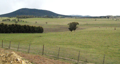
Photo taken 8 km ENE of Bendoc looking towards Mt Delegate
Soil Profile Morphology:
| Surface soil | |||
A1 | 0 – 20 cm | Black (10YR2/1); light clay to clay loam; pH 6.1; abrupt change to: | |
Subsoil | |||
B2 | 20 – 40+ cm | Dark greyish brown (10YR4/2) mottled with yellow brown (10YR5/4); medium to heavy clay; pH 7.2. | |
Chemical and Physical Analysis:
Horizon | Horizon Depth (cm) | pH (water) | pH (CaCl2) | EC dS/m | Exchangeable Acididty meq/100g | Exchangeable Cations | |||
Ca | Mg | K | Na | ||||||
meq/100g | |||||||||
A1 | 0-20 | 6.1 | 5.1 | 0.1 | 13 | 3.6 | 7 | 0.3 | 0.79 |
B2 | 20-40 | 7.2 | 6.2 | 0.08 | 6 | 2 | 8.3 | 0.21 | 0.86 |
Profile Described By: Ian Sargeant, 2011.
© State of Victoria (Agriculture Victoria) 1996 - .

This work, Victorian Resources Online, is licensed under a Creative Commons Attribution 4.0 licence. You are free to re-use the work under that licence, on the condition that you credit the State of Victoria (Agriculture Victoria) as author, indicate if changes were made and comply with the other licence terms.
The licence does not apply to ‘branding’ or some ‘images or photographs’ that may be owned by third parties. We ask you to seek prior approval to use images using the VRO feedback form. Access to higher quality images can also be provided on request.
This page was last updated on .