
River terraces (Symbol: rt)
EG7 | EG18 | EG214
A number of sets of terraces were formed in Gippsland during the Pleistocene period (about 1.8 million years ago to the present). Geologists have identified five terraces with Qp1 being the oldest and Qp5 the youngest. An additional terrace very slightly higher than the present river flats has been recognised during this study.
In this report they are all called ‘River Terraces’, and have been subdivided according to their position in the landscape with River Terrace (Components 1 to Component 6) corresponding to the Geological map units Qp1 to Qp5. The youngest terrace (Qrt) is called River Terrace (Component 6). The present flood plains (Qra) are called River Flats (rf).
River terrace, component 1 (Symbol: rt 1)
Minor occurrences of this terrace occur in the upper reaches of the Mitchell River and Perry River valleys but have not been found associated with the Snowy River.
River terrace, component 2 (Symbol: rt 2)
This terrace is found on higher ground well immediately north of Orbost and the vicinity of Gunns Road, Orbost. No observations were made but it is likely that the soils would be texture contrast soils and are probably stony.
River terrace, component 3 (Symbol: rt 3)
No examples of this terrace occur here.
River terrace, component 4 (Symbol: rt 4)
Most of Orbost is on this terrace, which is lower in elevation than Qp2 and higher than the present river flats.
River terrace, component 5 (Symbol: rt 5)
Small areas of this terrace occur along Jarrahmond Road, Orbost.
River terrace, component 6 (Symbol: rt 6)
This occurs in the Orbost area, just above the level of the present flood plain. No sites were examined on this terrace, but a similar but not defined terrace near Cann River showed little difference in soil characteristics between this terrace and the present flood plain.
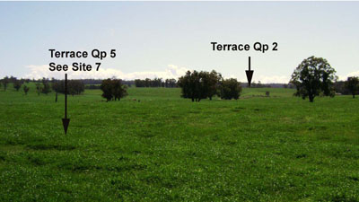
Photo taken near the corner of B and Jarrahmond Roads, Orbost (A. Christie)
Site EG7
| Location: Jarramond | Geo. Ref. 0622000E 5829100N |
| Australian Soil Classification: Bleached-Sodic, Magnesic, Grey KUROSOL (very thick loamy surface horizons) | Grey sodic texture contrast soil (deep surface) |
| General landscape description: Alluvial terrace | |
| Geology: Quaternary alluvium (Qp5) | |
| Site description: Upper terrace <1% slope | |
| Land use: Grazing | |
| Mapping unit: River terrace (Component 5) |
Soil profile morphology
| Surface soil | ||
A1 | 0 – 5 cm | Dark greyish brown (10YR4/2); loam; weak consistence moist; clear change to: |
A21 | 5 – 30 cm | Greyish brown (10YR5/2); silty loam; weak consistence moist; gradual change to: |
A22 | 30 – 50 cm | Greyish brown (10YR5/2); silty clay loam; weak coarse prismatic structure; weak consistence moist; gradual change to: |
Subsoil | ||
B21 | 75 – 105 cm | Greyish brown (10YR5/2); medium clay; weak coarse prismatic structure; firm consistence moist. |
Key profile features
| ||
| pH | Salinity rating | Sodicity | Dispersion | Slaking | |
| Surface soil (A11 horizon) | Strongly acid | Very low | Non Sodic | None1 | Slakes partially |
| Subsurface (A12 horizon) | Strongly acid | Very low | Sodic | None2 | Slakes partially |
| Deeper subsoil (75-105cm) | Strongly acid | Low | Sodic | None2 | Slakes partially |
2Complete after remoulding
| Horizon | Depth cm | Field texture | pH water | pH CaCl2 | EC dS/m | Coarse sand % | Fine sand % | Silt % | Clay % | Field cap. % w/w | Wilt. point % w/w | PAW* water % w/w |
| A21 | 5-30 | ZL | 5.4 | 4.5 | 0.1 | 2 | 51 | 25 | 15 | 25.4 | 11.2 | 14.2 |
| A22 | 30-50 | ZCL | 5.1 | 4.3 | 0.1 | 1 | 52 | 27 | 18 | |||
| A23 | 50-75 | ZCL | 5.4 | 4.3 | 0.11 | 1 | 52 | 27 | 18 | |||
| B21 | 75-105 | MC | 5.3 | 4.4 | 0.21 | 1 | 40 | 21 | 38 |
Sampled by auger
| Depth | Org C# | Total N | Free Fe2O3 | Exch. Al | Exchangeable cations meq/100 g | Ca:Mg | ESP | ||||||
| cm | % | % | % w/w | ppm | Ca | Mg | K | Na | Total | H | CEC | ||
| 5-30 | 2.5 | 0.22 | 18 | 2.4 | 2.1 | 0.71 | 0.35 | 5.6 | 12.0 | 13.2 | 1.2 | 3 | |
| 30-50 | 80 | 0.52 | 1.9 | 0.42 | 0.43 | 3.3 | 8.4 | 11.7 | 0.3 | 4 | |||
| 50-75 | 0.77 | 0.05 | 77 | 0.17 | 2.1 | 0.44 | 0.72 | 3.5 | 7.5 | 11.0 | 0.1 | 7 | |
| 75-105 | 180 | 0.14 | 5.7 | 0.55 | 1.9 | 8.3 | 10.0 | 18.3 | 0.1 | 10 | |||
Sampled by auger
Management considerations
Surface (A) Horizons
- The surface soil is strongly acid, but is unlikely to show any response to lime.
- As the surface soils have high fine sand and silt content they tend to set when wet following cultivation and subsequent irrigation unless the organic matter is maintained.
- The surface horizons have low inherent fertility (based on the sum of the exchangeable cations).
- The surface soil is quite high in potassium and no response to potassium fertilisers would be expected.
- Moderate levels of exchangeable aluminium in surface horizons.
- Sodic subsoils are typically moderately to strongly dispersive, but here are slightly dispersive. This is because of the high exchangeable aluminium (180 ppm).
- The cations are dominated by exchangeable magnesium which may create nutrient imbalances.
- The level of soluble salts is low.
- High exchangeable aluminium in the subsoil
- The sodic nature of the subsoil is unlikely to affect plants as is it too deep for all except deep rooted species, eg lucerne. Lucerne would also be adversely affected by the high levels of aluminium.
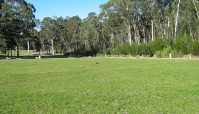
| Location: Jarramond | Geo. Ref. 0622000E 5829100N |
| Australian Soil Classification: Eutrophic, Mesonatric, Brown SODOSOL Brown sodic texture contrast soil (thick loamy) | Brown sodic texture contrast soil (deep surface) |
| General landscape description: Undulating rises | |
| Geology: Pleistocene alluvial sediments (Qp5) | |
| Site description: Road reserve, Upper slope, NNE aspect 8% slope | |
| Land use: Grazing | |
| Mapping unit: River terrace (Component 5) |
Soil profile morphology
| Surface soil | 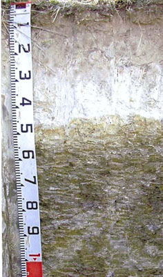 Profile similar to that described above | ||
A1 | 0 – 35 cm | Very dark grey (10YR3/1); fine sandy loam; moderate medium polyhedral structure; very weak consistence moist; clear change to: | |
A2 | 35 – 50 cm | Greyish brown (10YR5/2) conspicuously bleached (10YR7/2d); loamy fine sand; apedal; firm consistence dry; sharp change to: | |
Subsoil | |||
B21 | 50 – 100 cm | Brown (10YR5/3) mottled with black (10YR2/1); heavy clay; moderate coarse prismatic structure; strong consistence moderately moist. | |
Key profile features
| |||
| pH | Salinity rating | Sodicity | Dispersion | Slaking | |
| Surface soil (A1 horizon) | Strongly acid | Very low | Non sodic | None | Slakes partially |
| Subsoil (A2 horizon) | Slightly acid | Very low | Non sodic | Strong1 | Slakes partially |
| Deeper subsoil (50-100 cm) | Moderately acid | Low | Sodic | Strong1 | Slakes partially |
| Horizon | Depth cm | Field texture | pH water | pH CaCl2 | EC dS/m | Coarse sand % | Fine sand % | Silt % | Clay % | Field cap. % w/w | Wilt. point % w/w | PAW* water % w/w |
| A1 | 0-35 | FSL | 5.3 | 4.5 | 0.08 | 5 | 58 | 19 | 13 | 25.4 | 8.0 | 17.4 |
| A2 | 35-50 | LFS | 6.1 | 5.0 | 0.05 | 5 | 66 | 20 | 9 | |||
| B2 | 50-100 | HC | 5.9 | 4.9 | 0.23 | 2 | 37 | 13 | 47 |
| Depth | Org C# | Total N | Free Fe2O3 | Exch. Al | Exchangeable cations meq/100 g | Ca:Mg | ESP | ||||||
| cm | % | % | % w/w | ppm | Ca | Mg | K | Na | Total | H | CEC | ||
| 0-35 | 2.4 | 0.18 | 26 | 2.4 | 1.6 | 0.35 | 0.23 | 4.6 | 12 | 16.6 | 1.5 | 1 | |
| 35-50 | <10 | 0.76 | 0.91 | 0.17 | 0.32 | 2.2 | 3.7 | 5.9 | 0.9 | 5 | |||
| 50-100 | 18 | 1.1 | 6.9 | 0.92 | 2.5 | 11.4 | 11.0 | 22.4 | 0.2 | 11 | |||
Management considerations
Surface (A) Horizons
- The surface soil is strongly acid, but is unlikely to show any response to lime.
- As the surface soils have high fine sand and silt and low clay content they tend to set when wet following cultivation and subsequent irrigation unless the organic matter is maintained.
- The surface horizons have very low inherent fertility (based on the sum of the exchangeable cations).
- The surface soil is quite high in potassium and no response to potassium fertilisers would be expected.
- Because of the marked texture contrast between the surface soils and the sodic and dispersive subsoil, downward water movement is likely to be impeded, resulting in water table problems after prolonged periods of rain.
- The level of soluble salts is slightly higher than normal, but unlikely to cause problems as the surface soil is deep.
- The sodic nature of the subsoil is unlikely to directly affect plants as is it too deep. However water table problems may occur after rain.
| Location: Cann River flats | Geo. Ref. 0692200E 5846100N |
| Australian Soil Classification: Vertic (& Acidic-Sodic), Eutrophic, Grey DERMOSOL | Grey uniform textured soil |
| General landscape description: Alluvial plain | |
| Geology: Recent sediments | |
| Site description: Terrace flat >1% slope | |
| Land use: Grazing | |
| Original vegetation: Riparian forest | |
| Mapping unit: River terrace (Component 6) |
Soil profile morphology
| Surface soil | 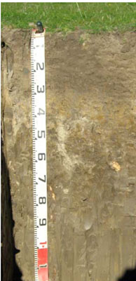 | ||
A1 | 0 – 25 cm | Very dark greyish brown (10YR3/2); light clay; moderate medium (5 – 10 mm) granular structure; weak consistence moist; clear change to: | |
Subsoil | |||
B21 | 25 – 60 cm | Dark grey (10YR4/1) mottled with dark yellowish brown; medium clay; moderate coarse (20 – 50 mm) polyhedral structure; very firm consistence moist; diffuse change to: | |
B21 | 60 -90 mm | Dark greyish brown (10YR4/2); heavy clay; weak coarse (20 – 50 mm) polyhedral structure; diffuse change to: | |
B22 | 90 – 120 cm | Greyish brown (10YR5/2); heavy clay; moderate coarse lenticular structure; very firm moist; weak coarse (20 – 50 mm) polyhedral structure. | |
Key profile features
| |||
| pH | Salinity rating | Sodicity | Dispersion | Slaking | |
| Surface soil (A1 horizon) | Moderately acid | Very low | Non sodic | None | Water stable |
| Subsoil (B21 horizon) | Moderately acid | Very low | Non sodic | None1 | Slakes considerably |
| Deeper subsoil (90 -120 cm) | Strongly acid | Higher than normal | Sodic | Slight | Slakes considerably |
| Horizon | Depth cm | Field texture | pH water | pH CaCl2 | EC dS/m | Coarse sand % | Fine sand % | Silt % | Clay % | Field cap. % w/w | Wilt. point % w/w | PAW* water % w/w |
| A1 | 0-25 | ZCL | 5.9 | 5.2 | 0.12 | 3 | 27 | 20 | 41 | 36.7 | 12.8 | 23.9 |
| B21 | 25-60 | MC | 5.6 | 4.5 | 0.07 | 2 | 27 | 21 | 45 | 30.9 | 14.7 | 16.2 |
| B22 | 60-90 | HC | 5.4 | 4.4 | 0.18 | 0 | 17 | 22 | 55 | 41.1 | 21.8 | 19.3 |
| B23 | 90-120 | HC | 5.3 | 4.5 | 0.29 | 0 | 16 | 15 | 54 | 43.5 | 21.9 | 21.6 |
| Depth | Org C# | Total N | Free Fe2O3 | Exch. Al | Exchangeable cations meq/100 g | Ca:Mg | ESP | ||||||
| cm | % | % | % w/w | ppm | Ca | Mg | K | Na | Total | H | CEC | ||
| 0-25 | 2.6 | 0.2 | <10 | 6.8 | 2.7 | 0.15 | 0.37 | 10 | 2.5 | ||||
| 25-60 | 0.92 | <0.05 | 51 | 3 | 4.7 | 0.053 | 0.63 | 8.4 | 7.9 | 16.3 | 0.6 | 4 | |
| 60-90 | 0.37 | <0.05 | 75 | 4.2 | 11 | 0.14 | 2.2 | 17 | 9.4 | 26.4 | 0.4 | 8 | |
| 90-120 | 0.37 | <0.05 | 69 | 3.1 | 9.5 | 0.09 | 1.8 | 14.5 | 8.4 | 22.9 | 0.3 | 8 | |
Whole Profile
- Plant available water content is moderate (estimated at 75 mm) for this soil profile. This is based on an estimated effective rooting depth of 50 cm (i.e. surface soil and upper subsoil). The denser and more coarsely structured deeper subsoil is likely to restrict rooting depth.
- Infiltration of water will be slow throughout the upper soil profile due to the high clay content of the soil profile.
- The level of soluble salts in the surface is low.
- Potassium levels are very low and a response to potassium fertilizer would be expected.
- The surface (A1) horizon has a moderate nutrient holding capacity based on the sum of the exchangeable calcium, magnesium and potassium cations).
- The organic matter content is high resulting in good structural condition and high structural stability. Maintaining the level of organic matter is important in maintaining the water and nutrient holding capacity of the soil.
- The coarsely structured deeper subsoil (from 60 cm depth) is sodic and has low exchangeable calcium to magnesium ratios (0.4). It is also strongly dispersive and slakes considerably. These conditions are likely to result in more restricted root and water movement in the deeper subsoil.
- Deep rooted species such as lucerne may be adversely affected by the high levels of aluminium in the subsoil.
© State of Victoria (Agriculture Victoria) 1996 - .

This work, Victorian Resources Online, is licensed under a Creative Commons Attribution 4.0 licence. You are free to re-use the work under that licence, on the condition that you credit the State of Victoria (Agriculture Victoria) as author, indicate if changes were made and comply with the other licence terms.
The licence does not apply to ‘branding’ or some ‘images or photographs’ that may be owned by third parties. We ask you to seek prior approval to use images using the VRO feedback form. Access to higher quality images can also be provided on request.
This page was last updated on .