
Murrungowar (Symbol: Mg)
Site 212 (Rees unpublished) | Site 215 (Rees unpublished)
Geology
Palaeozoic granites.
Landform
Rolling low hills. Elevation range in this report is 20 – 200 m, with slope gradients generally less than 20%.
Land use
Forestry, grazing, minor granite extraction (Orbost).
Native vegetation
Lowland forest and shrubby dry forest.
Soils
This map unit is of limited occurrence. In the context of this report it occurs around Orbost and Wangarabell. No pits or analyses were carried out on this soil.
Site 212 (Rees unpublished)
| Location: About 24 km NNE of Orbost on the Bonang Highway | Geo. Ref. 0633600E 5836400N |
| Australian Soil Classification: Bleached-mottled, Eutrophic, Brown CHROMOSOL | Yellow texture contrast soil |
| General landscape description: Rolling low hills | |
| Geology: Granite | |
| Site description: Lower slope of a low hill, NW aspect 20% slope | |
| Land use: Native forest | |
| Native vegetation: Lowland forest | |
| Mapping unit: Murrungowar |
Soil profile morphology
| Surface soil |
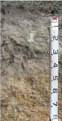 Road cutting near Wangarabell. Geo. Ref.: 721500E 5859000N | |||||||||||||||||||||||||||||||||||||||||||||||||||||||||
A1 | 0 – 6 cm | Brown (10YR4/3); light sandy loam; weak structure; clear change to: | ||||||||||||||||||||||||||||||||||||||||||||||||||||||||
A2 | 6 – 45 cm | Light yellowish brown (2.5Y 6/4), conspicuously bleached (2.5Y8/2); loamy sand; massive abrupt change to: | ||||||||||||||||||||||||||||||||||||||||||||||||||||||||
Subsoil | ||||||||||||||||||||||||||||||||||||||||||||||||||||||||||
B2 | 45 – 70 cm | Light olive brown (2.5Y5/4), many orange and light grey mottles; gritty medium clay; moderate angular blocky structure; gravelly, clear boundary to: | ||||||||||||||||||||||||||||||||||||||||||||||||||||||||
C | 70 – 1.4m | Weathered granite becoming hard rock. | ||||||||||||||||||||||||||||||||||||||||||||||||||||||||
Soil profile characteristics
| ||||||||||||||||||||||||||||||||||||||||||||||||||||||||||
| Location: Tongi Creek | Geo. Ref. 682900E 5841900N |
| Australian Soil Classification: Bleached-Mottled, Eutrophic, Brown CHROMOSOL | Acidic brown texture contrast soil |
| General landscape description: Low hills | |
| Geology: Granite | |
| Site description: Upper slope | |
| Land use: Forestry | |
| Native vegetation: Lowland forest | |
| Mapping unit: Murrungowar |
Soil profile morphology
| Surface soil | ||
A1 | 0 – 40 cm | Dark gray (10YR4/1); sandy loam, weak to moderate subangular blocky structure; firm consistence dry, common subangular gravel; clear change to: |
A2 | 40 – 80 cm | Brown (10YR5/3), conspicuously bleached (10YR7/2d); gravelly sandy loam; massive; weak consistence, very few ferruginous segregations; many subangular granitic gravel; clear change to: |
Subsoil | ||
B2 | 80 – 120 cm | Brown (10YR5/3), distinct to prominent yellow, red and grey mottles; sandy clay, moderate subangular blocky structure; very firm consistence, common subangular; gradual change to: |
C | 1.2 – 1.6+m | Weathered parent material |
Soil profile characteristics
| Horiz | Depth | EC | pH H2O | pH CaCl2 | Org C % | Total N % | Exch Al ppm | Exchangeable cations cmol(+)/kg | Ca:Mg | ESP | ||||||
| cm | dS/m | Ca | Mg | K | Na | Total | H | CEC | ||||||||
| A1 | 0-40 | <0.05 | 5.5 | 4.5 | 1.13 | <0.01 | 57 | 0.91 | 0.81 | 0.20 | 0.10 | 2.0 | 7.7 | 9.7 | 1.1 | 1 |
| A2 | 40-80 | <0.05 | 6.0 | 4.8 | 0.35 | <0.01 | 25 | 0.50 | 0.50 | 0.10 | 0.10 | 1.2 | 3.5 | 4.7 | 1.0 | 2 |
| B2 | 80-120 | <0.05 | 5.8 | 4.4 | 0.27 | <0.01 | 145 | 2.17 | 5.68 | 0.21 | 0.62 | 8.7 | 8.3 | 17.0 | 0.4 | 4 |
© State of Victoria (Agriculture Victoria) 1996 - .

This work, Victorian Resources Online, is licensed under a Creative Commons Attribution 4.0 licence. You are free to re-use the work under that licence, on the condition that you credit the State of Victoria (Agriculture Victoria) as author, indicate if changes were made and comply with the other licence terms.
The licence does not apply to ‘branding’ or some ‘images or photographs’ that may be owned by third parties. We ask you to seek prior approval to use images using the VRO feedback form. Access to higher quality images can also be provided on request.
This page was last updated on .