
McAdam (Symbol: Mc)
Geology
Devonian limestone; Buchan Group: Marine limestone, dolomite, well bedded, dark grey, re-crystallized.
Landform
The McAdam map unit encompasses rolling to steep hills at an elevation range of about 550 to 850 m and a relief range of 90 to 300 m. The slope gradients exceed 15% but are generally much steeper, commonly 20 to 40%.
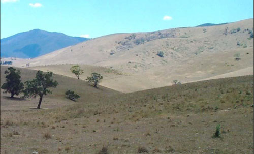
Bindi map unit: undulating low hills in the foreground; McAdam map unit: steep hills in the background.
Soils
Limited descriptions have been given by Aldrick et al. (1992). They describe the soils as being somewhat shallow clay loams to light clays with a maximum depth of less than 80 cm. Soil reaction varies from slightly acidic to alkaline. Shallower soils and appreciable rock outcrop occurs on the steeper slopes.
Similar soils to those described above also occur around Buchan, but there the elevation is much lower, about 70 to 350 m. However the slope gradients around Buchan are similar.
Original vegetation
Grassy woodland.
Land use
Most of the area has been cleared of original vegetation.
Management considerations
Sheet and rill erosion is likely to occur with low grass cover following drought or overgrazing.
© State of Victoria (Agriculture Victoria) 1996 - .

This work, Victorian Resources Online, is licensed under a Creative Commons Attribution 4.0 licence. You are free to re-use the work under that licence, on the condition that you credit the State of Victoria (Agriculture Victoria) as author, indicate if changes were made and comply with the other licence terms.
The licence does not apply to ‘branding’ or some ‘images or photographs’ that may be owned by third parties. We ask you to seek prior approval to use images using the VRO feedback form. Access to higher quality images can also be provided on request.
This page was last updated on .