
Gipsy Point (Symbol: Gp)
EG247
Geology
Palaeozoic sediments, often mantled by Tertiary sediments.
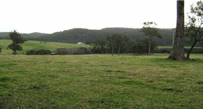
Landform
This map unit covers rolling low hills on sedimentary rock around Gipsy Point as well as around Orbost.
Native vegetation
Lowland forest
Soils
The soils are similar to those named ‘Tambo’ around Bairnsdale, but as they are closer to the coast are often mantled with Tertiary sediments, resulting in a variable depth of surface soil.
EG247
| Location: Gipsy Point | Geo. Ref. 0735400E 5847900N |
| Australian Soil Classification: Acidic-Sodic, Dystrophic, Yellow DERMOSOL | Acidic yellow gradational soil |
| General landscape description: Undulating low hills | |
| Geology: Palaeozoic sediments | |
| Site description: Crest of a low rise, northern aspect 2% slope | |
| Land use: Grazing | |
| Native vegetation: Lowland forest | |
| Mapping unit: Gipsy Point |
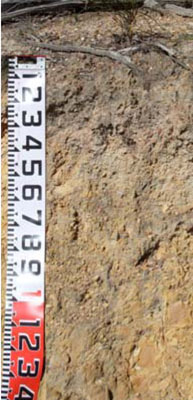
Soil profile morphology
| Surface soil |
 Road exposure nearby on Genoa Road | |||||||||||||||||||||||||||||||||||||||||||||||||||||||||
A1 | 0 – 35 cm | Dark greyish brown (10YR4/2); fine sandy loam; gradual change to: | ||||||||||||||||||||||||||||||||||||||||||||||||||||||||
Subsoil | ||||||||||||||||||||||||||||||||||||||||||||||||||||||||||
B1 | 35 – 50 cm | Yellowish brown (10YR5/6); fine sandy clay loam; gradual change to: | ||||||||||||||||||||||||||||||||||||||||||||||||||||||||
B2 | 50 – 80 cm | Brownish yellow (10YR6/8); fine sandy light clay. | ||||||||||||||||||||||||||||||||||||||||||||||||||||||||
Soil profile characteristics
Samples analysed by: Industry and Investment NSW (2010) | ||||||||||||||||||||||||||||||||||||||||||||||||||||||||||
© State of Victoria (Agriculture Victoria) 1996 - .

This work, Victorian Resources Online, is licensed under a Creative Commons Attribution 4.0 licence. You are free to re-use the work under that licence, on the condition that you credit the State of Victoria (Agriculture Victoria) as author, indicate if changes were made and comply with the other licence terms.
The licence does not apply to ‘branding’ or some ‘images or photographs’ that may be owned by third parties. We ask you to seek prior approval to use images using the VRO feedback form. Access to higher quality images can also be provided on request.
This page was last updated on .