
Dellicknora (Symbol: Dk)
EG238 | EG239 | EG241
Geology
Silurian granite.
Landform
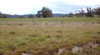
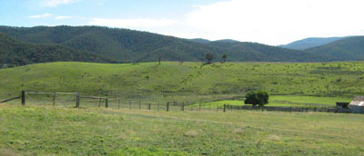
Enclosed low hills and valleys at elevations between 650 to 800 m with typical slope gradients are <32% with a relief of 30-90 m. The map unit may be subdivided into two components: crest and long gentle slopes, and low lying open depressions.
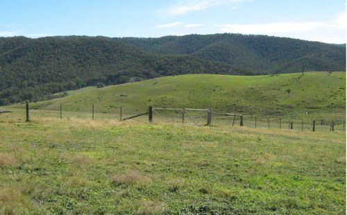
Cleared low hills on granite near Dellicknora
Native vegetation
Around Dellicknora, where the elevation is lower, the original vegetation on the slopes was heathy dry forest, whereas around Delegate River, where the elevation is slightly higher, it was a mix of montane dry woodland and riparian woodland. The landscape is similar to that around Omeo but the rainfall is higher, resulting in the soils being CHROMOSOLS rather than SODOSOLS.
Soils
Component 1: Soils on crests and long gentle slopes
The two profiles examined were both texture contrast soils with strongly acidic to moderately acidic weakly structured sandy loams that overlie a bleached subsurface of similar texture. The subsoils are brown to yellowish brown medium clay. See EG238, EG239 and EG241.
Component 2: Soils in low lying open depressions
One soil profile was examined, as well as observations along the sides of drainage lines. The surface soil is very dark grey acidic sandy loam (pH 5.0) overlying grey clay at about 80 cm. See Site 120 Rees (unpublished). This soil is described under the map unit ‘Valley Flats’.
Land use
Most of the lower slopes are cleared and used for grazing.
Site EG238
| Location: Delegate River | Geo. Ref. 0660800E 5894200N |
| Australian Soil Classification: Bleached, Eutrophic, Grey CHROMOSOL | Deep sandy grey texture contrast soil |
| General landscape description: Rolling low hills | |
| Geology: Silurian granite | |
| Site description: Mid south-west slope, 8 % | |
| Land use: Grazing | |
| Native vegetation: Montane riparian woodland and montane dry woodland | |
| Mapping unit: Dellicknora (Component 1) |
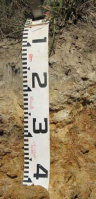
Soil profile morphology
| Surface soil | ||
A1 | 0 – 10 cm | Greyish brown (10YR5/2); coarse sandy loam; gradual change to: |
A2 | 10 - 80 cm | Pale brown (10YR6/3), conspicuously bleached (10YR7/2d); coarse sandy loam; abrupt change to: |
Subsoil | ||
B2 | 80 – 90+ cm | Brown (10YR4/2); medium clay (coarse sandy) with few (2-10%) fine (<2 mm) soft feldspar grains. |
Soil profile characteristics
| Horizon | Depth | EC | pH water | pH CaCl2 | Exchangeable cations cmol(+)/kg | Ca:Mg | ESP | ||||||
| cm | dS/m | Ca | Mg | K | Na | Total | H | CEC | |||||
| A1 | 0-10 | 0.06 | 5.8 | 5.1 | 4.1 | 0.95 | 0.2 | 0.11 | 5.3 | 5.6 | 10.9 | 4.3 | 1 |
| A2 | 10-80 | <0.05 | 6.1 | 5.4 | 1.1 | 0.41 | 0.06 | 0.07 | 1.6 | 2.6 | 4.2 | 2.7 | 1 |
| B2 | 80-90 | 0.07 | 6.1 | 5.4 | 6.9 | 4.1 | 0.37 | 0.17 | 12 | 5.3 | 17.3 | 1.7 | 1 |
Site EG239
| Location: Delegate River | Geo. Ref. 0661800E 5895100N |
| Australian Soil Classification: Bleached, Eutrophic, Brown CHROMOSOL | Brown texture contrast soil |
| General landscape description: Rolling low hills | |
| Geology: Ordovician sediments | |
| Site description: Upper west slope of low hill 5% slope | |
| Land use: Grazing | |
| Native vegetation: Montane riparian woodland and montane dry woodland | |
| Mapping unit: Dellicknora (Component 1) |
Soil profile morphology
| Surface soil | ||
A1 | 0 – 30 cm | Pale brown (10YR6/3), conspicuously bleached (10YR7/2d); fine sandy clay loam; clear change to: |
Subsoil | ||
B2 | 30 – 40+ cm | Brown (10YR5/3); medium clay. |
Soil profile characteristics
| Horizon | Depth | EC | pH water | pH CaCl2 | Exchangeable cations meq/100 g | Ca:Mg | ESP | ||||||
| cm | dS/m | Ca | Mg | K | Na | Total | H | CEC | |||||
| A1 | 0-10 | <0.05 | 5.5 | 4.5 | 1.4 | 0.75 | 0.16 | 0.17 | 2.5 | 6.8 | 9.3 | 1.9 | 2 |
| B2 | 30-40 | <0.05 | 5.6 | 4.3 | 2.3 | 5.8 | 0.18 | 0.67 | 8.9 | 14 | 22.9 | 0.4 | 3 |
Site EG241
| Location: Delegate River | Geo. Ref. 0661800E 5895100N |
| Australian Soil Classification: Bleached, Eutrophic, Brown CHROMOSOL | Brown texture contrast soil |
| General landscape description: Rolling low hills | |
| Geology: Ordovician sediments | |
| Site description: Upper west slope of low hill 5% slope | |
| Land use: Grazing | |
| Native vegetation: Montane riparian woodland and montane dry woodland | |
| Mapping unit: Dellicknora (Component 1) |
Soil profile morphology
| Surface soil |
 Road cutting adjoining the sampled site | |||||||||||||||||||||||||||||||||||||||||||||||||||||||||
A1 | 0 – 10 cm | Dark greyish brown (10YR4/2); sandy loam; weak coarse polyhedral structure; gradual change to: | ||||||||||||||||||||||||||||||||||||||||||||||||||||||||
A2 | 10 – 35 cm | Light yellowish brown (10YR6/4) conspicuously bleached (10YR7/2d); massive; abrupt change to: | ||||||||||||||||||||||||||||||||||||||||||||||||||||||||
Subsoil | ||||||||||||||||||||||||||||||||||||||||||||||||||||||||||
B2 | 35 - 60+ cm | Mottled yellowish brown (10YR5/6) and yellow (10YR7/6) medium clay; moderate coarse angular blocky structure. | ||||||||||||||||||||||||||||||||||||||||||||||||||||||||
Soil profile characteristics
| ||||||||||||||||||||||||||||||||||||||||||||||||||||||||||
© State of Victoria (Agriculture Victoria) 1996 - .

This work, Victorian Resources Online, is licensed under a Creative Commons Attribution 4.0 licence. You are free to re-use the work under that licence, on the condition that you credit the State of Victoria (Agriculture Victoria) as author, indicate if changes were made and comply with the other licence terms.
The licence does not apply to ‘branding’ or some ‘images or photographs’ that may be owned by third parties. We ask you to seek prior approval to use images using the VRO feedback form. Access to higher quality images can also be provided on request.
This page was last updated on .