
Delegate (Symbol: Dg)
EG223 | EG234
Geology
Palaeozoic sediments, some granites.
Landform
Undulating to rolling hills at elevations between 200 to 900 m with typical slope gradients generally less than 32% and a relief of 90 – 300 m
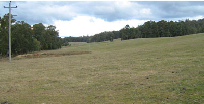
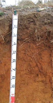
Photo taken near Murrungowar. Red gradational soil on granite Geo. Ref.: 649700E 5834700N
Native vegetation:
It is likely that the native vegetation would have been wet forest and damp forest.
Soils
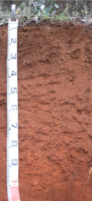
These are deeply weathered soils may also occur on granites. Very few soil observations were made on this map unit, but they are likely to be red and brown gradational soils. Due to lack of observations, this map unit has not been subdivided into any components.
Land use
Most of the land is used for native forestry and plantation forestry, with some areas cleared for pasture.
Site EG223
| Location: Bonang | Geo. Ref. 0669900E 5887030N |
| Australian Soil Classification: Acidic, Red DERMOSOL | Acidic red gradational soil |
| General landscape description: Rolling low hills | |
| Geology: Palaeozoic sediments | |
| Site description: Simple slope 2% south east | |
| Land use: Grazing | |
| Native vegetation: Wet forest | |
| Mapping unit: Delegate |
Soil profile morphology
| Surface soil |
 Roadside exposure adjoining site; deep red soil. | ||||||||||||||||||||||||||||||||||||||||||||||||||||||||||
A11 | 0 – 38 cm | Dark reddish brown (5YR3/2); clay loam; moderate to strong fine 2 – 5 mm) granular structure; weak consistence dry; pH 5.2; gradual change to: | |||||||||||||||||||||||||||||||||||||||||||||||||||||||||
A12 | 38 – 60 cm | Reddish brown (5YR3/3); clay loam; moderate fine 2 – 5 mm) granular structure; weak consistence moist; pH 5.1. | |||||||||||||||||||||||||||||||||||||||||||||||||||||||||
Soil profile characteristics
| |||||||||||||||||||||||||||||||||||||||||||||||||||||||||||
| Depth | Org C | Total N | Free Fe2O3 | Exch. Al | Exchangeable cations cmol (+)/kg | Ca:Mg | ESP | ||||||
| cm | % | % | % w/w | ppm | Ca | Mg | K | Na | Total | H | CEC | ||
| 0-20 | 4.3 | 0.21 | 220 | 1.5 | 0.87 | 0.59 | 0.14 | 3.1 | 16 | 19.1 | 1.7 | 1 | |
| 40-60 | 3.0 | 0.11 | 290 | 0.79 | 0.34 | 0.14 | 0.12 | 1.4 | 17 | 18.4 | 2.3 | 1 | |
Site EG234
| Location: About 500m south of the Delegate River. | Geo. Ref. 0666200E 5881300N |
| Australian Soil Classification: Acidic, Dystrophic, Red DERMOSOL | Acidic red gradational soil |
| General landscape description: Rolling low hills | |
| Geology: Ordovician sediments | |
| Site description: Simple slope 2% south east | |
| Land use: Hardwood plantation | |
| Mapping unit: Delegate |
Soil profile morphology
| Surface soil |
 | |||||||||||||||||||||||||||||||||||||||||||||||||||||||||
A1 | 0 – 40 cm | Dark reddish brown (5YR3/3); clay loam; strong fine granular structure; very weak consistence, moist; pH 5.0; gradual change to: | ||||||||||||||||||||||||||||||||||||||||||||||||||||||||
Subsoil | ||||||||||||||||||||||||||||||||||||||||||||||||||||||||||
B1 | 40 – 60 cm | Dark red (2.5YR3/6); light clay; moderate medium granular structure; weak consistence moist; pH 4.9; gradual change to: | ||||||||||||||||||||||||||||||||||||||||||||||||||||||||
B2 | 60 – 1.0+ m | Red (2.5YR4/6); medium clay; moderate medium polyhedral structure; firm consistence moist. | ||||||||||||||||||||||||||||||||||||||||||||||||||||||||
Soil profile characteristics
| ||||||||||||||||||||||||||||||||||||||||||||||||||||||||||
© State of Victoria (Agriculture Victoria) 1996 - .

This work, Victorian Resources Online, is licensed under a Creative Commons Attribution 4.0 licence. You are free to re-use the work under that licence, on the condition that you credit the State of Victoria (Agriculture Victoria) as author, indicate if changes were made and comply with the other licence terms.
The licence does not apply to ‘branding’ or some ‘images or photographs’ that may be owned by third parties. We ask you to seek prior approval to use images using the VRO feedback form. Access to higher quality images can also be provided on request.
This page was last updated on .