
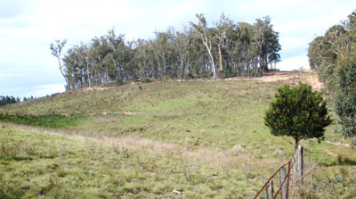
Bendoc (Symbol: Bd)
EG222 | EG235 | EG237 | EG240 | EG243 | Site 133 (Rees unpublished) | EG236
Geology
Palaeozoic sediments.
Landform
Rolling hills to rolling low valleys at elevations between 600 to 900 m with typical slope gradients are 8-20% with a relief of 30-90 m. Some uncleared areas, eg Mt Bendoc, have slightly higher relief. The map unit may be subdivided into two components: crest and long gentle slopes; and low lying open depressions.
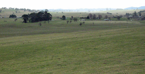
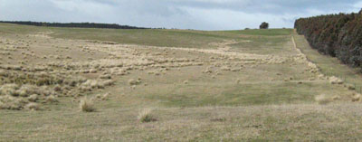
Photo taken on the Lower Bendoc Road near Lower Bendoc
Native vegetation:
Mostly montane dry woodland with the area south of the Bendoc River likely to be montane grassy woodland.
Soils
Component 1: Soils on crests and long gentle slopes
The five soils examined had strongly acidic fine sandy or silty loam surface soils overlying strongly to slightly acidic clay subsoils. The subsoils are generally brown to yellowish brown in colour however in areas where rock occurs at a shallow depth, the subsoil colours tend to be redder.
Component 2: Soils in low lying open depressions
One soil adjoining a drainage line was examined and is regarded as being typical of this landscape position. This profile was slightly acid and clayey throughout.
Land use
Most of the lower slopes are cleared and used for grazing.
Site EG222
| Location: Bendoc | Geo. Ref. 0671000E 5887500N |
| Australian Soil Classification: Acidic, Mesotrophic, Red DERMOSOL | Acidic red gradational soil |
| General landscape description: Undulating low hills | |
| Geology: Ordovician sediments | |
| Site description: Simple upper slope 5% south west | |
| Land use: Grazing | |
| Native vegetation: Montane grassy woodland | |
| Mapping unit: Bendoc (Component 1) |
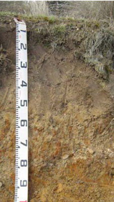
Soil profile morphology
| Surface soil | 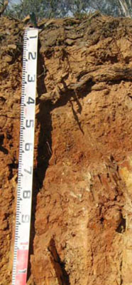 | ||
A1 | 0 – 15 cm | Dark brown (7.5YR3/2); very fine sandy loam; weak fine (2 – 5 mm) structure; weak consistence dry; few (2 – 10%) angular tabular coarse (20 – 60 mm) pebbles; pH 5.2; clear change to: | |
A2 | 15 – 40 cm | Brown (7.5YR5/4); very fine sandy clay loam; massive; weak consistence dry; common (10 – 20%) angular tabular coarse (20 – 60 mm) pebbles; pH 5.0; abrupt change to: | |
Subsoil | |||
B2 | 40 – 70 cm | Red (2.5YR4/6); very fine sandy light clay; moderate coarse (20 – 50 mm) polyhedral structure; strong consistence moist; abundant (50 – 90%) angular tabular cobbles (60 – 200 mm); rock fragments increasing with depth; pH 5.4; diffuse change to: | |
R | 70+ cm | Moderately weathered rock. | |
Key profile features
| |||
Soil profile characteristics
| pH | Salinity rating | Sodicity | Dispersion | Slaking | |
| Surface soil (A1 horizon) | Strongly acid | Very low | Non sodic | None | Water stable |
| Subsoil (B1 horizon) | Strongly acid | Very low | Non sodic | None1 | Partially water stable |
| Deeper subsoil (80-110 cm) | Strongly acid | Very low | Non sodic | None | Partially water stable |
| Horizon | Depth cm | Field texture | pH water | pH CaCl2 | EC dS/m | Coarse sand % | Fine sand % | Silt % | Clay % | Field cap. % w/w | Wilt. point % w/w | PAW* water % w/w |
| A1 | 0-10 | VFSL | 5.2 | 4.5 | 0.09 | 14 | 50 | 14 | 10 | 25.6 | 10.6 | 15.0 |
| A2 | 10-40 | VFSCL | 5.0 | 4.2 | 0.06 | 15 | 45 | 11 | 23 | 25.0 | 5.3 | 19.7 |
| B2 | 40-60 | VFSLC | 5.4 | 4.6 | 0.06 | 16 | 47 | 12 | 24 | 30.9 | 7.9 | 20.0 |
| Depth | OrgC# | Total N | Free Fe2O3 | Exch. Al | Exchangeable cations meq/100 g | Ca:Mg | ESP | ||||||
| cm | % | % | % w/w | ppm | Ca | Mg | K | Na | Total | H | CEC | ||
| 0-10 | 5 | 0.3 | 44 | 3.5 | 1.3 | 0.5 | 0.17 | 5.4 | 13.0 | 18.4 | 2.7 | 1 | |
| 10-40 | 1.1 | <0.05 | 160 | 0.47 | 0.31 | 0.3 | 0.19 | 1.3 | 7.9 | 8.2 | 1.5 | 2 | |
| 40-60 | 0.44 | <0.05 | 63 | 0.46 | 0.72 | 0.28 | 0.22 | 1.7 | 5.9 | 7.6 | 0.6 | 3 | |
Management considerations
Whole profile
- Plant available water is considered to be low (estimated at 50 mm) for this profile. This is based on an estimated and effective rooting depth of 70 cm (i.e. depth above the decomposing rock) and the presence of decomposing rock within this depth.
- The low wilting points of each horizon to this depth is low (ie 10.6, 5.3 and 7.9 %) indicating plants are able to use light rains when the soil is dry. Due to the low water storage capacity, plants will suffer moisture stress unless further rains occur.
- As mentioned above, the surface soils can hold little water, but plants can use light rains following a dry spell.
- The surface soil is strongly acid. As the exchangeable aluminium is also high a response to lime would be expected. The use of test strips is the most appropriate way of determining the amount of lime needed.
- The nutrient holding capacity of the surface horizons is low (based on the sum of the calcium, magnesium, potassium and sodium cations).
- The organic matter content of the surface soil is high which helps maintain soil fertility and water holding capacity. The soil below 10 cm has a low organic matter content which would explain its low wilting point and very low nutrient holding capacity.
- The potassium is at a moderate level for pastures and no response to added potassium would be expected.
- The increasing amounts of decomposing rock are likely to restrict pasture root development. Those of native plant species are able to follow cracks in the rock and are less restricted.
| Location: Bendoc North | Geo. Ref. 0671000E 5887500N |
| Australian Soil Classification: Yellow KUROSOL | Acidic yellow texture contrast soil |
| General landscape description: Undulating low hills | |
| Geology: Ordovician sediments | |
| Site description: Lower hill-slope, 5% slope to north-west | |
| Land use: Grazing | |
| Native vegetation: Montane grassy woodland | |
| Mapping unit: Bendoc (Component 1) |
Soil profile morphology
| Surface soil |
 | |||||||||||||||||||||||||||||||||||||||||||
A1 | 0 – 15 cm | Dark grey (10YR4/1); fine sandy loam; firm dry; weak medium polyhedral structure; clear change to: | ||||||||||||||||||||||||||||||||||||||||||
A2 | 15 – 35 cm | Greyish brown (10YR5/2) conspicuously bleached (10YR7/2d); fine sandy loam; massive; very firm consistence dry; common (10-20%) angular tabular pebbles (20-60 mm); clear change to: | ||||||||||||||||||||||||||||||||||||||||||
Subsoil | ||||||||||||||||||||||||||||||||||||||||||||
B2 | 35 – 45+ cm | Yellowish brown (10YR5/4); medium clay. | ||||||||||||||||||||||||||||||||||||||||||
Soil profile characteristics
| ||||||||||||||||||||||||||||||||||||||||||||
| Location: Bendoc East | Geo. Ref. 0670700E 5884600N |
| Australian Soil Classification: Acidic, Dystrophic, Brown DERMOSOL | Acidic yellow texture contrast soil |
| General landscape description: Undulating low hills | |
| Geology: Ordovician sediments | |
| Site description: Mid to lower slope, 10% to south-east | |
| Land use: Grazing | |
| Native vegetation: Montane grassy woodland | |
| Mapping unit: Bendoc (Component 1) |
Soil profile morphology
| Surface soil | ||
A1 | 0 – 5 cm | Dark greyish brown (10YR4/2); silty clay loam; clear change to: |
Subsoil | ||
B1 | 5 – 20 cm | Yellowish brown (10YR5/4); silty light clay; pH 4.9; clear change to: |
B2 | 20 – 50 + cm | Yellowish brown (10YR5/6); light medium clay; pH 4.9. |
Soil profile characteristics
| Horizon | Depth | EC | pH water | pH CaCl2 | Exchangeable cations meq/100 g | Ca:Mg | ESP | ||||||
| cm | dS/m | Ca | Mg | K | Na | Total | H | CEC | |||||
| B1 | 5-20 | <0.05 | 4.9 | 4.1 | 0.66 | 0.52 | 0.38 | 0.09 | 1.7 | 15 | 16.7 | 1.3 | <1 |
| B2 | 35-45 | <0.05 | 4.9 | 4.2 | 0.37 | 0.39 | 0.32 | 0.08 | 1.2 | 11 | 12.2 | 1 | <1 |
Site EG240
| Location: Dellicknora | Geo. Ref. 0652600E 5893000N |
| Australian Soil Classification: Undetermined Eutrophic, Red CHROMOSOL | Brown texture contrast soil |
| General landscape description: Rolling low hills | |
| Geology: Ordovician sediments | |
| Site description: Lower east-north-east slope of low hill 5% slope | |
| Land use: Grazing | |
| Native vegetation: Shrubby dry forest | |
| Mapping unit: Bendoc (Component 1) |
Soil profile morphology
| Surface soil |
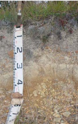
 Erosion gully nearby the site | |||||||||||||||||||||||||||||||||||||||||||||||||||||||||
A1 | 0 – 30 cm | Brownish yellow (10YR6/6); fine sandy loam; pH 5.1; clear change to: | ||||||||||||||||||||||||||||||||||||||||||||||||||||||||
Subsoil | ||||||||||||||||||||||||||||||||||||||||||||||||||||||||||
B2 | 30 – 40+ cm | Reddish brown (5YR5/4); light clay (sandy); pH 6.1. | ||||||||||||||||||||||||||||||||||||||||||||||||||||||||
Soil profile characteristics
| ||||||||||||||||||||||||||||||||||||||||||||||||||||||||||
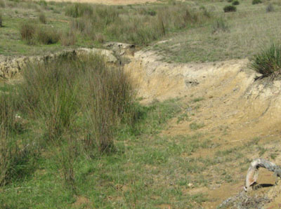
Site EG243
| Location: Bendoc North | Geo. Ref. 0679500E 5886500N |
| Australian Soil Classification: Mesotrophic, Subnatric, Brown SODOSOL | Sodic brown texture contrast soil |
| General landscape description: Undulating low hills | |
| Geology: Ordovician sediments north aspect | |
| Site description: Upper slope, aspect, 2% slope | |
| Land use: Grazing and plantation timber | |
| Native vegetation: Montane grassland | |
| Mapping unit: Bendoc (Component 1) |
Soil profile morphology
| Surface soil |
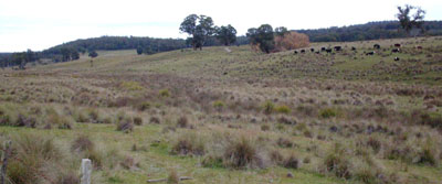
 Road exposure a short distance from sampled site | |||||||||||||||||||||||||||||||||||||||||||||||||||||||||
A1 | 0 – 30 cm | Dark yellowish brown (10YR4/4); very fine sandy loam; weak fine granular structure; weak consistence dry; pH 5.5; gradual change to : | ||||||||||||||||||||||||||||||||||||||||||||||||||||||||
A2 | 30 – 60 cm | Pale brown (10YR6/2); very fine loamy sand; massive; very weak consistence dry; abrupt change to: | ||||||||||||||||||||||||||||||||||||||||||||||||||||||||
Subsoil | ||||||||||||||||||||||||||||||||||||||||||||||||||||||||||
B2 | 60 – 80 cm | Mottled pale brown (10YR6/3) and red (2.5YR4/6); medium clay; pH 6.1. | ||||||||||||||||||||||||||||||||||||||||||||||||||||||||
Soil profile characteristics
Analysed by Industry and Investment NSW (2010) | ||||||||||||||||||||||||||||||||||||||||||||||||||||||||||
Site 133 (Rees unpublished)
| Location: Bendoc North (Approx 200 m east of EG 236) | Geo. Ref. 0673900E 5888500N |
| Australian Soil Classification: Bleached, Magnesic, Brown CHROMOSOL | Brown texture contrast soil |
| General landscape description: Undulating to rolling low hills | |
| Geology: Ordovician sediments | |
| Site description: Mid slope, 8% to south | |
| Land use: Grazing | |
| Mapping unit: Bendoc (Component 1) |
Soil profile morphology
| Surface soil | ||||||||||||||||||||||||||||||||||||||||||||||||||||||||||||||||||||||||
A11 | 0 – 5 cm | Dark brown (10YR3/3); loam; weak fine angular blocky structure; common (10 – 20%) rounded pebbles (6 - 20 mm); clear change to: | ||||||||||||||||||||||||||||||||||||||||||||||||||||||||||||||||||||||
A12 | 5 – 30 cm | Dark brown (10YR4/3); fine sandy loam; massive; common (10 – 20%) rounded pebbles; pH 5.7; clear change to: | ||||||||||||||||||||||||||||||||||||||||||||||||||||||||||||||||||||||
A2 | 30 – 60 cm | Pale brown (10YR 6/3); conspicuously bleached; fine sandy clay loam; massive; common (10 – 20%) angular pebbles; pH 6.0; clear change to: | ||||||||||||||||||||||||||||||||||||||||||||||||||||||||||||||||||||||
Subsoil | ||||||||||||||||||||||||||||||||||||||||||||||||||||||||||||||||||||||||
B2 | 60 – 140+ cm | Yellowish brown (10YR5/4); light medium clay; strong medium angular blocky structure; common (10 – 20%) angular pebbles; pH 6.0. | ||||||||||||||||||||||||||||||||||||||||||||||||||||||||||||||||||||||
Soil profile characteristics
| ||||||||||||||||||||||||||||||||||||||||||||||||||||||||||||||||||||||||
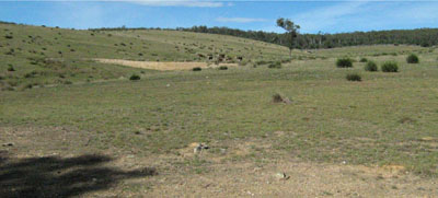
Site EG236
| Location: Bendoc North | Geo. Ref. 0674100E 5888500N |
| Australian Soil Classification: Mottled, Eutrophic, Grey CHROMOSOL | Grey texture contrast soil |
| General landscape description: Undulating to rolling low hills | |
| Geology: Ordovician sediments | |
| Site description: Lower position in the landscape, Lower north-east slope of a low rise, 3% slope | |
| Land use: Grazing | |
| Mapping unit: Bendoc (Component 2) |
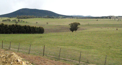
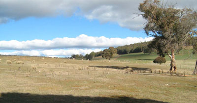
Photo taken 8 km ENE of Bendoc looking towards Mt Delegate
| Surface soil | ||||||||||||||||||||||||||||||||||||||||||||||||||||||||||
A1 | 0 – 20 cm | Black (10YR2/1); light clay to clay loam;pH 6.1; abrupt change to: | ||||||||||||||||||||||||||||||||||||||||||||||||||||||||
Subsoil | ||||||||||||||||||||||||||||||||||||||||||||||||||||||||||
B2 | 20 – 40+ cm | Dark greyish brown (10YR4/2) mottled with yellow brown (10YR5/4); medium to heavy clay; pH 7.2. | ||||||||||||||||||||||||||||||||||||||||||||||||||||||||
Soil profile characteristics
| ||||||||||||||||||||||||||||||||||||||||||||||||||||||||||
© State of Victoria (Agriculture Victoria) 1996 - .

This work, Victorian Resources Online, is licensed under a Creative Commons Attribution 4.0 licence. You are free to re-use the work under that licence, on the condition that you credit the State of Victoria (Agriculture Victoria) as author, indicate if changes were made and comply with the other licence terms.
The licence does not apply to ‘branding’ or some ‘images or photographs’ that may be owned by third parties. We ask you to seek prior approval to use images using the VRO feedback form. Access to higher quality images can also be provided on request.
This page was last updated on .