
Turton (Symbol: Tn)
Geology
Late Devonian freshwater sediments.
Landform
Steep hills. Elsewhere in the Gippsland Lakes Catchment the landform is steep hills and steep mountains. The elevation range is 180 - 1400 m with local relief 180 – 660 m. Typical slope gradients exceed 15% but are generally much steeper, commonly 20 - 40%.
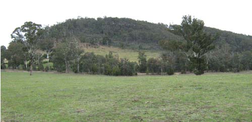
In the area covered by this report, the Turton Map unit comprises steep rounded hills and straight steep slopes.
Steep forest slopes of Mount Lookout. The area in the foreground is mapped into the Deadhorse Map unit
Original vegetation
Grassy woodland.
Soils
Component 1: Soils on steep slopes and rounded crests
The soils are very shallow and often stony. Aldrick (1992) describes the surface soils as dark greyish brown sandy loams to loams merging into greyish brown or reddish brown sandy loam or sandy clay loam subsoil. Some subsoils may be yellowish brown clays. The percentage of exposed stone is up to 40%.
Component 2: Soils in open depressions
Deep gullies have formed in many of the open depressions. The exposed gully walls reveal a range of soils from very dark grey clays to yellow texture contrast soil. No soils were examined on this unit.
Component 3: Steep slopes
Steep slopes, ranging from 20 – 50% or more, often adjoin the streams and major drainage lines. Rock is frequently exposed at the surface. No soils were examined on this unit.
Land use
The land is mostly cleared and used for grazing.
© State of Victoria (Agriculture Victoria) 1996 - .

This work, Victorian Resources Online, is licensed under a Creative Commons Attribution 4.0 licence. You are free to re-use the work under that licence, on the condition that you credit the State of Victoria (Agriculture Victoria) as author, indicate if changes were made and comply with the other licence terms.
The licence does not apply to ‘branding’ or some ‘images or photographs’ that may be owned by third parties. We ask you to seek prior approval to use images using the VRO feedback form. Access to higher quality images can also be provided on request.
This page was last updated on .