
Tinamba (Symbol: Ti)
Profile No. 58 (Aldrick et al, 1992)
Geology
Late Pleistocene alluvial sediments. This unit includes areas mapped as Qpa on the Bairnsdale geological map and delineates the youngest terrace above the present flood plain of the Mitchell River.
Landform
Stagnant alluvial plain. This is defined as an alluvial plain where erosion and aggradation, by channelled and overbank stream flow, is barely active or inactive due to reduced water supply. It fringes only parts of the Mitchell River Flats.
Original vegetation
Dry valley forest.
Soils
Most, but not all, of the soils have a weak texture contrast between the surface soil and the subsoil. The majority have a dominantly brown fine sandy loam to fine sandy clay loam surface soil. Usually a clear change occurs at about 35 to 45 cm to dominantly red or brown light to medium clays becoming fine sandy clays to light clays before 1 m. The profile described here has a deeper surface soil than usual.
Previous maps and reports
This Map unit was included with the Maffra 2 Land System by Aldrick (1992) and because of its limited extent was not separated from the river flats. These soils occur extensively in the Maffra Irrigation Area and support irrigated perennial pastures.
Land use
These soils are mostly used for grazing. Some cropping occurs west of Bairnsdale.
Profile No. 58 (Aldrick et al, 1992)
| Location: Bairnsdale East | Geo. Ref.: 557500E 5812400N |
| Australian Soil Classification: Melanic, Eutrophic, Red DERMOSOL | Brown gradational soil (deep surface) |
| General landscape description: Gently undulating plain | |
| Geology: Pleistocene alluvial sediments | |
| Site description: 4% slope of a relict terrace | |
| Land use: Pasture | |
| Original vegetation: Dry valley forest | |
| Map unit: Tinamba |
Soil profile morphology
| Surface soil | 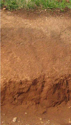 Soil exposure in channel near Hands Road, Lindenow. | ||
| A11 | 0 – 15 cm | Black (10YR2/1); clay loam; strong angular blocky structure (10 mm); hard when dry; gradual change to: | |
| A12 | 15 – 20 cm | Dark brown (7.5YR3/2); clay loam; weak angular blocky structure (5 mm); hard dry; clear change to: | |
| A2 | 20 – 40 cm | Dark brown (7.5YR3/4); clay loam; massive; very hard dry; clear change to: | |
| A3 | 40 – 70 cm | Dark brown (7.5YR3/4) with common faint reddish brown mottles; light clay; weak subangular blocky structure (20 mm); very hard dry; gradual change to: | |
| Subsoil | |||
| B2 | 70 – 105 cm | Yellowish red (5YR4/6); medium clay; abundant reddish brown mottles and common black mottles; moderate angular blocky structure (20 mm); very hard dry; gradual change to: | |
| C | 105 – 150+ cm | Reddish brown (5YR4/4) with common faint brown mottles; light clay; massive; hard dry. |
Key profile features
- Soil sampled by Aldrick et al. (1992) is somewhat atypical as it has a black surface. Normally the Tinamba soils have a dark brown surface similar to that in the above photograph.
- Deep surface soil, but the subsurface sets hard when dry.
- Gradual increase in texture to 105 cm.
| pH | Salinity rating | Sodicity | Dispersion | Slaking | |
| Surface soil (A11 horizon) | Moderately acid | Very low | |||
| Subsurface soil (A2 horizon) | Slightly acid | Very low | |||
| Subsoil (B horizon) | Slightly alkaline | Very low | Sodic |
| Horizon | Depth cm | Field texture | pH water | EC dS/m | Gravel % | Coarse sand % | Fine sand % | Silt % | Clay % | Field cap. % w/w | Wilt. point % w/w |
| A11 | 0-10 | CL | 5.7 | 0.09 | 7 | 5 | 47 | 22 | 22 | ||
| A2 | 20-30 | CL | 6.1 | 0.05 | 4 | 2 | 53 | 22 | 20 | ||
| A3 | 40-60 | LC | 6.8 | 0.02 | 1 | 3 | 57 | 21 | 19 | ||
| B2 | 70-90 | MC | 7.2 | 0.08 | 3 | 3 | 45 | 15 | 33 | ||
| C | 120-150 | LC | 7.4 | 0.10 | 0 | 4 | 58 | 15 | 23 |
| Depth | OrgC# | Total N | Free Fe2O3 | Exch. Al | Exchangeable cations cmol(+)/kg | Ca:Mg | ESP | ||||||
| cm | % | % | % w/w | ppm | Ca | Mg | K | Na | Total | H | CEC | ||
| 0-10 | 3.5 | 0.35 | 5.3 | 1.8 | 0.8 | 0.3 | 8.2 | 15.5 | 23.7 | 2.9 | |||
| 20-30 | 1.6 | 0.14 | 1.4 | 4.7 | 1.4 | 0.2 | 0.2 | 6.5 | 9.2 | 15.7 | 3.4 | ||
| 40-60 | 1.4 | 2.5 | 1.5 | 0.1 | 0.2 | 4.3 | 4.3 | 8.6 | 1.7 | ||||
| 70-90 | 2.8 | 2.6 | 4.5 | 0.2 | 1.1 | 7.4 | 6.1 | 13.5 | 0.6 | 8 | |||
| 120-150 | 2.0 | 3.8 | 0.1 | 1.4 | 7.3 | 2.0 | 9.3 | 0.5 | 15 | ||||
Management considerations
Surface (A) horizons
- The surface soil is relatively deep, providing a good environment for plant growth provided the soil is moist.
- The surface soil has a high fine sand content (47%). When cultivated in a dry condition it will become ‘powdery’ and subsequent rainfall may result in surface sealing occurring. Soils such as these rely to a large extent on organic matter for maintaining aggregation. The level of organic carbon measured at the sample site is moderate, with an organic matter estimated at 6%.
- The potassium levels in the soil are high and no response to potassium fertiliser would be expected.
- Although water and root movement may be restricted by the sodic and clayey upper subsoil, the surface soil is sufficiently deep for adequate root growth.
© State of Victoria (Agriculture Victoria) 1996 - .

This work, Victorian Resources Online, is licensed under a Creative Commons Attribution 4.0 licence. You are free to re-use the work under that licence, on the condition that you credit the State of Victoria (Agriculture Victoria) as author, indicate if changes were made and comply with the other licence terms.
The licence does not apply to ‘branding’ or some ‘images or photographs’ that may be owned by third parties. We ask you to seek prior approval to use images using the VRO feedback form. Access to higher quality images can also be provided on request.
This page was last updated on .