
Roseneath (Symbol: Rn)
Profile No. 41 (Aldrick et al, 1982)
Geology
Recent marine sediments mantled with some aeolian sediments.
Landform
Marine plain. Plains comprising clay flats and some small saline swamps, often mantled by sand. These plains have been formed by the exposure of earlier lake floors and occur mainly around Lake Wellington.
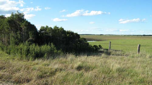
Remnant vegetation adjoining Holland’s Landing Road
Previous maps and reports
This map unit was mapped as Clydebank Land System by Aldrick et al. (1992) and under Roseneath and Wulla Wullock by Nicholson (1978). Areas where extensive dunefields occur are mapped as the Seacombe map unit.
Soils
Many of the surface soils are slightly acidic dark grey clays but north of Lake Wellington within the Strathfieldsaye Estate the clays are often mantled by a thin layer of sand. With depth the soil generally becomes alkaline and increasingly saline.
Native Vegetation
Swamp scrub.
Land use
Mostly cleared and used for grazing.
Profile No. 41 (Aldrick et al, 1982)
| Location: 4 km SE of Meerlieu | Geo. Ref.: 536500E 5890800N |
| Australian Soil Classification: Epihypersodic, Epipedal, Black VERTOSOL | Grey cracking clay |
| General landscape description: Plain | |
| Geology: Holocene lacustrine sediments | |
| Site description: <1% slope | |
| Land use: Grazing | |
| Native vegetation: Swamp scrub | |
| Map unit: Roseneath |
Soil profile morphology
Surface soil
| A11 | 0 - 4 cm | Very dark brown (10YR2/2); organic clay loam; weak very fine (5 mm) subangular blocky structure; slightly hard consistence, dry; abrupt change to: |
| A12 | 4 – 12 cm | Very dark grey (10YR3/1); loamy clay; weak fine (10 mm) subangular blocky structure; hard consistence dry; clear change to: |
| B21 | 12 – 25 cm | Very dark greyish brown (10YR3/2); medium clay; moderate fine (10 mm) subangular blocky structure; very firm consistence moist; clear change to: |
| B22 | 28 – 80 cm | Yellowish brown (10YR5/4); heavy clay; common distinct yellowish brown mottles (5 – 14 mm); moderate medium angular blocky structure; very firm moist; some water-worn gravel between 10 and 30 cm; clear boundary to: |
| C1 | 80 – 110 cm | Light grey (10YR7/2); clay loam; common distinct yellowish brown mottles (>15 mm); moderate angular block structure; firm moist; 3% calcareous nodules. |
Key profile features
- Clay textures throughout the profile.
| Horizon | Depth cm | Field texture | pH water | EC dS/m | Gravel % | Coarse sand % | Fine sand % | Silt % | Clay % | Field cap. % w/w | Wilt. point % w/w | PAW* water % w/w |
| A11 | 0-4 | Org CL | 5.7 | 0.18 | 8 | 2 | 21 | 13 | 51 | |||
| A12 | 4-10 | C | 5.9 | 0.11 | 5 | 13 | 25 | 14 | 45 | |||
| B21 | 12-20 | MC | 6.8 | 0.14 | 17 | 4 | 30 | 25 | 38 | |||
| B22 | 30-60 | HC | 8.3 | 1.20 | 11 | 7 | 32 | 13 | 51 | |||
| C1 | 90-110 | CL | 9.3 | 2.20 | 41 | 4 | 38 | 15 | 45 |
| Depth | Org C | Total N | Free Fe2O3 | Exch. Al | Exchangeable cations cmol(+)/kg | Ca:Mg | ESP | ||||||
| cm | % | % | % w/w | ppm | Ca | Mg | K | Na | Total | H | CEC | ||
| 0-4 | 7.7 | 0.57 | 0.7 | 4.3 | 4.5 | 1.7 | 1.2 | 11.7 | 23.9 | 35.6 | 1.0 | 3 | |
| 4-10 | 3.0 | 0.27 | 0.7 | 2.8 | 3.2 | 0.9 | 1.1 | 8.0 | 16.8 | 24.8 | 0.9 | 4 | |
| 12-20 | 1.5 | 0.14 | 1.1 | 4.1 | 6.8 | 0.7 | 2.5 | 14.1 | 8.6 | 22.7 | 0.6 | 11 | |
| 30-60 | 1.7 | 4.2 | 11.4 | 1.0 | 7.9 | 24.5 | 4.3 | 28.2 | 0.4 | 28 | |||
| 90-110 | 0.4 | 4.8 | 9.2 | 0.7 | 7.7 | 22.4 | 22.4 | 0.5 | 34 | ||||
Management considerations
Whole profile
- No additional lime or potassium is needed for pasture growth.
- When the soil is dry, heavy rains will move down cracks. This rapid recharge will be valuable for the survival of plants near wilting. When wet, the soil will swell and further infiltration of water will be relatively slow.
- The surface soil will be difficult to manage, being hard and cloddy when dry and firm and sticky when wet. As a consequence, these soils are generally suited to pasture production. Tillage or overstocking of these soils should be avoided if the soil is wet.
- From a depth of 30 cm the soil is extremely sodic and has high and harmful levels of soluble salts. This would greatly restrict root growth.
© State of Victoria (Agriculture Victoria) 1996 - .

This work, Victorian Resources Online, is licensed under a Creative Commons Attribution 4.0 licence. You are free to re-use the work under that licence, on the condition that you credit the State of Victoria (Agriculture Victoria) as author, indicate if changes were made and comply with the other licence terms.
The licence does not apply to ‘branding’ or some ‘images or photographs’ that may be owned by third parties. We ask you to seek prior approval to use images using the VRO feedback form. Access to higher quality images can also be provided on request.
This page was last updated on .