
Gormandale (Symbol: Go)
EG240
Geology
Pleistocene aeoliandeposits.
Landform
Dunefield.
No landscape photo available.
Native vegetation
Sand heathland.
Soils
The soils are mainly deep sands, generally with a layer of organic and/or iron cemented sand in the form of coffee rock or concretions in the subsoil. The soil described below is near Stradbroke.
Previous maps and reports
This map unit is included within the Gormandale Land System as described by Aldrick et al (1992). It also includes a number of deep sand soil types described by Poutsma and Turvey (1979)
Land use
Much of the land is under native vegetation and included in the Gippsland Lakes Coastal Park and the Lakes National Park. Some is cleared and grazed and there is some urban development at Loch Sport.
Site EG240
| Location: Stradbroke | Geo. Ref.: 0504800E 5764900N |
| Australian Soil Classification: Melacic, Humosesquic, Aeric PODOSOL | Uniform textured deep sand |
| General landscape description: Longitudinal dunefield | |
| Geology: Pleistocene aeolian sediments | |
| Site description: 7 % slope to north | |
| Native Vegetation: Sandy heathland | |
| Map unit: Gormandale |
Soil profile morphology
Surface soil
| A1 | 0 – 30 cm | Very dark greyish brown (10YR3/2); loamy sand; single grained; very weak consistence, moist; pH 3.8; clear and smooth change to: | 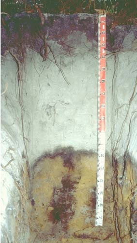 |
| A2 | 30 – 50 cm | Light grey (10YR6/1); sand; single grained; loose when dry; pH 4.2; diffuse and smooth change to | |
| A22 | 50 – 115 cm | White (10YR8/1); sand; single grained; loose when dry; pH 4.6; sharp and wavy change to: | |
| Subsoil | |||
| Bhs | 115 – 135 cm | Dark reddish brown (5YR3/3) and yellowish red (5YR5/8); sand; with continuous tongues of weakly cemented and massive ‘coffee rock’ pH 4.2; gradual and smooth transition to: | |
| C | 135 – 190 cm | Dark reddish brown (5YR3/3) and yellowish red (5YR5/8);sand; single grained; many ferruginous nodules (less than 60 mm) | |
- Deep sandy surface horizons.
- Conspicuously bleached, very thick subsurface (A2) horizons.
- Accumulation or iron-organic matter compounds (i.e. ‘coffee rock’) in subsoil.
- The soil profile is extremely acid throughout.
- The levels of coarse sand are high throughout the profile.
- The level of soluble salts is very low throughout the profile.
- The clay content is very low throughout the profile.
| pH | Salinity rating | Sodicity | Dispersion | |
| Surface (A1 horizon) | Extremely Acid | Very low | Non-sodic | None |
| Subsoil (Bhs horizon) | Extremely Acid | Very Low | Non-sodic | None |
| Horizon | Depth cm | Field texture | pH water | pH CaCl2 | EC dS/m | Coarse sand % | Fine sand % | Silt % | Clay % | Field cap. % w/w | Wilt. point % w/w | PAW* water % w/w |
| A1 | 0-30 | 3.8 | 3.0 | <0.05 | 64 | 28 | 1 | 2.5 | 7.6 | 3.7 | 3.9 | |
| A21 | 30-50 | 4.2 | 3.5 | <0.05 | 66 | 31 | 0.5 | 0 | 2.9 | 0.9 | 2.0 | |
| A22 | 50-115 | 4.6 | 4.2 | <0.05 | 62 | 35 | 0 | 0.5 | 2.5 | 0.6 | 1.9 | |
| Bhs | 115-135 | 4.2 | 3.8 | 0.05 | 5.1 | 2.6 | 2.5 |
| Depth | OrgC# | Total N | Free Fe2O3 | Exch Al | Exchangeable cations meq/100 g | Ca:Mg | ESP | ||||||
| cm | % | % | % w/w | ppm | Ca | Mg | K | Na | Total | H | CEC | ||
| 0-30 | 2.0 | 0.06 | 0.15 | 0.23 | 0.06 | 0.07 | 14 | ||||||
| 30-50 | <0.05 | 0.06 | <0.05 | <0.05 | 1.8 | ||||||||
| 50-115 | <0.05 | <0.05 | <0.05 | <0.05 | <1 | ||||||||
| 115-135 | 0.43 | <0.05 | <0.05 | <0.05 | <0.05 | <0.05 | 9.3 | ||||||
Management considerations
- Plant available water capacity (PAWC) is very low for sandy soils such as these. The soils are, however, well drained.
- These strongly acidic sandy soils have a very low nutrient holding capacity and are considered infertile – being naturally deficient in nitrogen, phosphorus, sulphur and potassium. Nitrate and sulphate are readily removed by leaching. Deficiencies of trace elements such as copper, zinc and molybdenum are likely to occur. The trace element boron (B) leaches rapidly through acid sandy soils and deficiencies are also likely to occur.
© State of Victoria (Agriculture Victoria) 1996 - .

This work, Victorian Resources Online, is licensed under a Creative Commons Attribution 4.0 licence. You are free to re-use the work under that licence, on the condition that you credit the State of Victoria (Agriculture Victoria) as author, indicate if changes were made and comply with the other licence terms.
The licence does not apply to ‘branding’ or some ‘images or photographs’ that may be owned by third parties. We ask you to seek prior approval to use images using the VRO feedback form. Access to higher quality images can also be provided on request.
This page was last updated on .