
Deadhorse (Symbol: Dh)
EG266
Geology
This map unit comprises soils mostly derived from the Devonian porphyry granites. Some areas of soils derived from the later Devonian freshwater sediments may also be included.
Landform
Rolling hills to rolling low hills. Elevation range 60 – 280 m with local relief 60 – 180 m, slope gradients generally less than 20% but on steeper slopes up to 40%. The unit may be subdivided into moderate to steep slopes, gently to moderately inclined slopes and gently inclined open drainage lines.
Original vegetation
Low herb rich forest
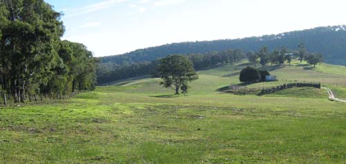
The largely uncleared land in the background is comprised of the steeper slopes. Most of the gentle and moderate slopes are cleared.
| Previous maps and reports This map unit was included under the Deadhorse Land System in the report by Aldrick et al. (1992). Soils Component 1: Soils of the steeper slopes No pits were examined. The soils are likely to be shallow sandy soils with areas of surface stone and boulders. Component 2: Soils on moderate to gentle slopes One soil pit was sampled and some roadside exposures examined. The soils are texture contrast soils with a sandy loam surface overlying yellowish brown clay. Generally the immediate subsurface is bleached. Component 3: Soils in open depressions These comprise less than 5% of the map unit and were not examined. The likelihood of gully and tunnel erosion in these soils is high as they are likely to be sodic. | 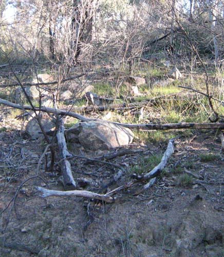 Surface stone and boulders occur on the steeper slopes |
| Location: Mount Taylor | Geo.Ref.: 547800E 5820500N |
| Australian Soil Classification: Bleached-Sodic, Magnesic, Brown CHROMOSOL | |
| General landscape description: Rolling low hills | |
| Geology: Devonian granite (porphyry) | |
| Site description: ENE slope, 13% slope | |
| Vegetation: Lowland herb rich forest | |
| Map unit: Deadhorse (Component 2) |
Soil Profile Morphology
Surface soil
| A1 | 0 – 10 cm | Dark grey (7.5YR4/1); sandy loam; weak coarse angular blocky structure; very firm dry; clear change to: | 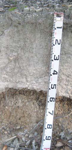 No soil pit photo available, but this was taken on a road exposure nearby. The surface soil is deeper than the sampled soil |
| A2 | 10 – 45 cm | Pale brown (10YR6/3), conspicuously bleached (7.5YR8/1); loamy sand; massive; abrupt change to: | |
| Subsoil | |||
| B21 | 40 – 90 cm | Greyish brown (10YR5/2), common (10-20%) coarse (15-30 mm) yellowish brown (10YR5/6) distinct mottles; medium clay; strong very coarse angular blocky structure parting to fine angular blocky; strong consistence dry; very few (<2%) rounded cobbles (60-200 mm); diffuse change to: | |
| B22 | 90 – 120 cm | Dark greyish brown (10YR4/2), many (20-50%) coarse (15-30 mm) yellowish brown (10YR5/8) distinct mottles; medium clay; strong coarse angular blocky structure; strong consistence dry; very few (<2%) rounded cobbles (60-200 mm); diffuse change to: | |
| B23 | 120 – 170 | Light grey (10YR7/2), few very coarse (>30 mm) reddish yellow (5YR6/8) mottles; medium clay; coarse prismatic structure; very strong dry; few rounded cobbles. | |
- Strong texture contrast between the surface (A) horizons and the subsoil (B) horizon
- Strongly bleached subsurface soil (A2) horizon.
Soil profile characteristics
| pH | Sodicity | Slaking | Dispersion Dry | Dispersion Remoulded | |
| Surface soil (A1 horizon) | Moderately acid | Non-sodic | Water stable | Nil (2 hours), Nil (20 hours) | Nil (2 hours), Nil (20 hours) |
| Subsoil (B21 horizon) | Strongly acid | Non-sodic | Considerable | Nil (2 hours), Slight (20 hours) | Strong (2 hours), Complete (20 hours) |
| Deeper subsoil (B22 horizon) | Strongly acid | Sodic | Considerable | Dispersive and non-dispersive aggregates | Strong (2 hours), Complete (20 hours) |
| Horizon | Depth cm | Field texture | pH water | pH CaCl2 | EC dS/m | Coarse sand % | Fine sand % | Silt % | Clay % | Field cap. % w/w | Wilt. point % w/w | PAW* water % w/w |
| A1 | 0-10 | SL | 5.6 | 4.7 | <0.05 | 30 | 36 | 17 | 10 | 27 | 6.1 | 20.9 |
| A2 | 10-45 | LS | 5.7 | 4.7 | <0.05 | 34 | 35 | 25 | 7 | 15.7 | 3 | 12.7 |
| B21 | 45-90 | MC | 5.5 | 4.2 | 0.06 | 19 | 22 | 14 | 44 | 29.1 | 16.8 | 12.3 |
| B22 | 90-120 | MC | 5.3 | 4.3 | 0.15 | 19 | 21 | 16 | 45 | 37.1 | 17.8 | 19.3 |
| Depth | OrgC# | Total N | Free Fe2O3 | Exch. Al | Exchangeable cations cmol(+)/kg | Ca:Mg | ESP | ||||||
| cm | % | % | % w/w | ppm | Ca | Mg | K | Na | Total | H | CEC | ||
| 0-10 | 2.9 | 0.17 | 56 | 2.2 | 1.2 | 0.3 | <0.1 | 3.8 | 9 | 12.8 | 1.8 | ||
| 10-45 | 45 | 0.4 | 0.5 | <0.1 | <0.1 | 1.1 | 4.5 | 5.6 | 0.8 | ||||
| 45-90 | 220 | 0.4 | 4 | 0.2 | 0.5 | 5.1 | 12 | 16.1 | 0.1 | 3 | |||
| 90-120 | 160 | 0.1 | 5.9 | 0.2 | 1 | 7.2 | 9.2 | 16.4 | 0.02 | 6 | |||
Management considerations
Whole profile
- On the assumption the roots can extract the water in the top 45 cm of the soil, the plant available water capacity is very low, estimated at 40 mm.
- The surface soil is moderately acidic and, because it is also moderately high in aluminium, lime application may be of benefit.
- Potassium is deficient and a response to potassium fertiliser is likely. This would particularly apply if pasture has been baled and removed from the site.
- The nutrient holding capacity of the soil is very low (based on the sum of the basic cations).
- Based on the sum of the basic cations, the subsoil has an extremely low nutrient holding capacity.
- The subsoil is sodic and strongly dispersive. The risk of gully and tunnel erosion is high in such soils.
- The level of exchangeable aluminium is high in the subsoil and would have a significant effect on species sensitive to aluminium.
© State of Victoria (Agriculture Victoria) 1996 - .

This work, Victorian Resources Online, is licensed under a Creative Commons Attribution 4.0 licence. You are free to re-use the work under that licence, on the condition that you credit the State of Victoria (Agriculture Victoria) as author, indicate if changes were made and comply with the other licence terms.
The licence does not apply to ‘branding’ or some ‘images or photographs’ that may be owned by third parties. We ask you to seek prior approval to use images using the VRO feedback form. Access to higher quality images can also be provided on request.
This page was last updated on .