
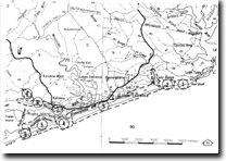
GL5/6 (8522) Hopetoun Channel, Hidden Lake
|
This information has been developed from the publications:
|
| Location: | 825050 to 845060 (8422). 2 kilometres east of artificial entrance at Lakes Entrance. | |
Abstract: | Tidal channel and lagoon; barriers. | |
Access: | Boat from Lakes Entrance. | |
Ownership: | Crown land, some private land. | |
Geolomorphology: | Hopetoun Channel (GL-5), is a wide, sinuous, shallow tidal channel south of Rigby Island that previously linked Lake King with Cunninghame Arm. Hopetoun Channel is dominantly a flood-tide channel with broad sandy tidal flats flanked by narrow ebb spits and swash bars. Since the opening of the artificial entrance, the channel has probably become shallower as it has replaced the Cunninghame Arm as a major distributary of flood-tide water. The configuration of Hopetoun Channel is such that wind action is less effective than on Cunninghame Arm as a major distributary of flood-tide water. The configuration of Hopetoun Channel is such that wind action is less effective than on Cunninghame Arm, and this combined with the strong tidal flow reduces the incidence of cuspate spit development on the shoreline. Hidden Lake (GL-6), is a narrow, small lagoon connected to Hopetoun Channel by a shallow, swampy, tidal channel. This lake is the easternmost of several elongated lagoons that mark the former extension of Bunga Arm. | |
Significance: | Regional. The changing configuration of the sandy bottom topography of Hopetoun Channel is an illustration of the increased importance of tidal flow in the Gippsland Lakes since the opening of the artificial entrance. Hidden Lake is a remnant of a more extensive tidal lagoon system (Bunga Arm) that has been progressively isolated by the eastward extension of the outer barrier. When studied in conjunction with the sandy terrain that encloses it, it provides important evidence of the nature of late Holocene barrier development in the Lakes Entrance area. | |
Management: | Management strategies should minimise the disturbance to areas adjacent to these sites. The lake could be subject to infilling by sand if blow-outs are activated on the dune ridges of the Ninety Mile Beach. Further property residential subdivision could cause accelerated eutrophication and development of anaerobic bottom conditions leading to rapid infilling of the lake. | |
References: | Bird, E.C.F. (1978). The Geomorphology of the Gippsland Lakes Region. Publication No. 186, Environmental Studies Series, Ministry for Conservation, Victoria. | |
© State of Victoria (Agriculture Victoria) 1996 - .

This work, Victorian Resources Online, is licensed under a Creative Commons Attribution 4.0 licence. You are free to re-use the work under that licence, on the condition that you credit the State of Victoria (Agriculture Victoria) as author, indicate if changes were made and comply with the other licence terms.
The licence does not apply to ‘branding’ or some ‘images or photographs’ that may be owned by third parties. We ask you to seek prior approval to use images using the VRO feedback form. Access to higher quality images can also be provided on request.
This page was last updated on .