
GL30 (8422) Rotomah Island
This information has been developed from the publications:
|
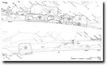
| Location: | Easting 600 to Easting 700, Northing 940 to Northing 005. | |
Abstract: | Barrier formations, dunes and dune lakes; relict entrance channels; tidal delta islands. | |
Access: | Road to Sperm Whale Head and Rotomah Island. Boat access only to other areas. | |
Ownership: | Some Crown Land (The Lakes National Park and Gippsland Lakes Coastal Park), private land. | |
Geology: | All materials exposed here of Quaternary origin and include Pleistocene and Holocene barriers, dune rings, beach and lake shore sands, and swamp deposits. | |
Geomorphology: | Rotomah Island is low and sandy and includes beach ridge formations eroding on the northern shore but fringed by Juncus and salt marsh on the more sheltered side. The spacing of the ridge crests, the depth of soil development indicates a Pleistocene rather than Holocene age for most of the island, hence it is a remnant of an earlier barrier formation perhaps equivalent to the inner part of the Boole Boole Peninsula and the southern section of Sperm Whale Head. | |
Significance: | National. (Sites GL28, GL29, GL30, GL31 and GL32). The association of features here is of major importance in illustrating the evolution of the barrier systems of the Gippsland Lakes. Many details still remain to be worked out concerning the sequence of Pleistocene and Holocene depositional and erosional events and the sites described could be the subject of major studies in geomorphology supported by stratigraphy, palynology and radiometric dating. | |
Management: | The area requires maximum protection. Extensive grazing, trampling, construction works, roadworks, dredging or quarrying will lead to destruction of sensitive sand ridges and wetlands and could cause mobilization of dunes. | |
© State of Victoria (Agriculture Victoria) 1996 - .

This work, Victorian Resources Online, is licensed under a Creative Commons Attribution 4.0 licence. You are free to re-use the work under that licence, on the condition that you credit the State of Victoria (Agriculture Victoria) as author, indicate if changes were made and comply with the other licence terms.
The licence does not apply to ‘branding’ or some ‘images or photographs’ that may be owned by third parties. We ask you to seek prior approval to use images using the VRO feedback form. Access to higher quality images can also be provided on request.
This page was last updated on .