
Tanjil (Tj)
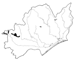 | Area: 210 sq. km (1.0%) Tanjil land system occurs on hilly terrain with plutonic and gneissic rocks, mainly in the south-west of the East Victorian Uplands. Ridge-and-ravine topography prevails but there is some rounding of ridge crests. Slopes are steep and moderately long. Areas are similar in geology and topography to Timbarra land system but they are much more humid. High rainfall acting on granodiorites, granites and gneisses has produced deep soils. Profiles are generally well aggregated, particularly in the upper horizons, and are moderately acidic. Layered open forest III is most common, with some open forest II on slopes at lower elevations. | 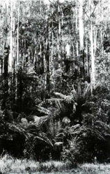 Protected steep slopes with a humid Eucalyptus regnans (mountain ash) forest |
| CLIMATE Rainfall, mean (mm) Temperature, mean (°C) Seasonal growth limitations |
Annual 900 - 1600; lowest January or February (60 - 90), highest August or October (120 - 150) Annual 8 - 12; lowest July (3 - 7), highest February (16 - 20) Temperature <10°C (av.): April - October Rainfall < potential evapotranspiration: February; frequent winter snow |
| GEOLOGY Age, lithology |
Palaeozoic granodiorites, granites and coarsely crystalline gneisses |
| PHYSIOGRAPHY Landscape Elevation range (m) Relative relief (m) Drainage pattern Drainage density (km/km2) |
Steep hills with a subdued ridge-and-ravine topography 260 - 1460 80 - 300 Dendritic 1.5 |
| PRESENT LAND USE |
|
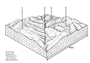 | 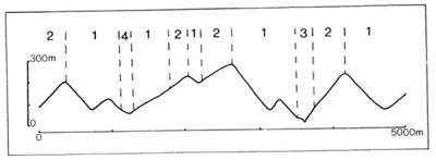 |
| LAND COMPONENT Percentage of land system Diagnostic features | 1 70 Slopes | 2 15 Protected slopes | 3 10 Terraces in major drainage corridors | 4 5 Minor drainage depressions |
| PHYSIOGRAPHY Slope %, typical and (range) Slope shape | 20 - 25, (10 - 60) Straight | 20 - 25, (10 - 60) Straight | <5, (0 - 10) Straight but uneven | Variable, (5 - 30) Concave |
| SOIL | ||||
| Parent material | Granodiorite, granite and associated gneiss | Mixed alluvium | Locally derived alluvium and colluvium | |
| Description | Mainly brown or red, some yellow, gradational, acidic soils; sandy clay loam to light clay subsoil, usually with fine blocky structure. On protected slopes topsoil is darker coloured and much deeper | Limited observations — probably mainly undifferentiated brown sand | Variable: brown sandy loam to sandy clay loam; high surficial organic matter and very stony in places | |
| Classification | Red, Brown and Yellow Earths, some Yellow Podzolic Soils and Lithosols Gn2.11, Gn4.11, Gn4.34, Gn4.54, Gn3.74, Um5.52 | Alluvial soils Uc1.44 | Brown Earths Uc6.11 | |
| Surface texture | Loamy fine sand to sandy clay loam; sandy loam common | Sand to sandy clay loam | Sandy loam to sandy clay loam | |
| Surface consistence | Friable to firm when moist | - | Friable when moist | |
| Depth (m) | >1.5 | >2.0 | >2.0 | |
| Nutrient status | Low to moderate | Low to moderate | Low to moderate | |
| Available soil water capacity | Moderate; high for more organic soils | Variable, depending on texture | Moderate | |
| Perviousness to water | Rapid | Moderate | Rapid | |
| Drainage | Good | Good | Moderately good | |
| Exposed stone (%) | Generally 0 | 0 | Variable; 0 - 40 | |
| Sampled profile number | - | - | - | |
| NATIVE VEGETATION Structure of vegetation and characteristic species of dominant stratum (+ Predominant species) | Highest elevations — layered open forest III: E. dives, E. delegatensis, E. rubida Lower elevations — open forest II, III, often shrubby: E. sieberi+, E. cypellocarpa and/or E. obliqua | Open forest III, IV, often layered: Highest elevations — E. delegatensis Lower elevations — E. regnans occasionally with E. nitens; E. regnans and/or E. obliqua, E. cypellocarpa; E. sieberi sometimes associated on upper slopes | Open forest III, IV, often layered: E. viminalis usually predominant; Nothofagus cunninghamii may be associated in higher rainfall areas | Open forest III, IV, often layered or ferny: Highest elevations — E. delegatensis Lower elevations — E. regnans with or without E. cypellocarpa, E. obliqua, E. rubida; Dicksonia antarctica often present |
|
|
|
|
| ||
|
|
| ||||
— reduction in leaf area, rooting depth and/or perenniality |
resulting in: a) increased deep percolation b) increased regolith wetness |
Nutrient loss Landslip |
Not determined 12; low |
Not determined Uncommon |
Removal of trees Accelerated by major disturbance of native vegetation |
Increased movement of water to groundwater; increased base-flow of streams Increased sediment load |
|
|
|
4; very low |
|
|
|
|
With Reduced infiltration |
Sheet and rill erosion |
2,4; high 1,2; moderate 4; very low |
Uncommon |
As for sheet and rill erosion above |
Increased flash flows |
|
|
Streambank erosion |
3; high |
Uncommon |
As for sheet and rill erosion above |
Increased sediment load |
| ||||||
© State of Victoria (Agriculture Victoria) 1996 - .

This work, Victorian Resources Online, is licensed under a Creative Commons Attribution 4.0 licence. You are free to re-use the work under that licence, on the condition that you credit the State of Victoria (Agriculture Victoria) as author, indicate if changes were made and comply with the other licence terms.
The licence does not apply to ‘branding’ or some ‘images or photographs’ that may be owned by third parties. We ask you to seek prior approval to use images using the VRO feedback form. Access to higher quality images can also be provided on request.
This page was last updated on .