
Timbarra (Ta)
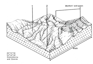
 | Area: 195 sq. km (1.0%) This land system is mapped on hills with plutonic and gneissic rocks, a ridge-and-ravine topography and moderately long steep slopes with outcropping rock and stone. Levees and alluvial flats similar to, but smaller than, those mapped in Walnut land system occur along a few major streams, notably the Timbarra River. The land system is found mainly in the Swifts Creek-Ensay area and near Timbarra, frequently on the higher peaks within areas of Dargo land system. It is similar to Blomford land system but has lower relief and shorter growing seasons. It is also similar in geology and topography to Tanjil land system but the climate is much drier. In this moderately-high rainfall environment, the granitic rocks tend to weather relatively rapidly. On steep upper slopes the soil is continually mixed by natural erosion and by disturbances such as tree throw so that the soils are little differentiated and leached, acidic, sandy, structureless, red earths have developed. The incomplete weathering of clay-forming minerals may also have contributed to the lack of profile differentiation. On more-gentle lower slopes, blocky clay subsoils are common. These subsoils tend to be neutral to slightly alkaline and are probably prone to gullying, particularly in drainage lines and valley floors. Topsoils are susceptible to sheet erosion. Shrubby open forest I or II is predominant, and open forest III often occurs in drainage corridors. |  Timbarra land system is similar to Blomford land system except that relief is lower and the slopes are less steep, generally with slightly deeper soils. As a result greater proportion of Timbarra land system (foreground) has been cleared. |
| CLIMATE Rainfall, mean (mm) Temperature, mean (°C) Seasonal growth limitations |
Annual 700 - 1200; lowest January or February (40 - 80), highest October (100 - 150) Annual 8 - 12; lowest July (3 - 7), highest February (16 - 20) Temperature <10°C (av.): May - September Rainfall < potential evapotranspiration: November – March |
| GEOLOGY Age, lithology |
Palaeozoic granites, granodiorites, diorites and coarsely crystalline gneisses |
| PHYSIOGRAPHY Landscape Elevation range (m) Relative relief (m) Drainage pattern Drainage density (km/km2) |
Steep hills will ridge-and-ravine topography 60 - 720 80 - 260 Dendritic 1.5 |
| PRESENT LAND USE |
Cleared portion: grazing of beef cattle and sheep |
 |  |
| LAND COMPONENT Percentage of land system Diagnostic features | 1 95 Slopes with stony soils and dry forest | 2 5 Isolated terraces and fans along major drainage corridors |
| PHYSIOGRAPHY Slope %, typical and (range) Slope shape | 20 - 30, (10 - 50) Straight | <2, (0 - 10) Straight but uneven |
| SOIL | ||
| Parent material | Granite, granodiorite, diorite and gneissic rock | Alluvium |
| Description | Dark greyish brown sandy loam topsoil grading into reddish brown sandy loam to coarse sand (mostly steep upper slopes); dark greyish brown sandy loam to clay loam over yellowish brown or brown mottled clay subsoil (mostly mid- and lower slopes) | Limited observations — variable soils; mainly brown or slightly reddish brown sandy loam to sandy clay loam over stratified alluvium |
| Classification | Red Earths, Yellow Podzolic Soils, Solodic Soils Uc4.12, Uc5.21; Gn2.86, Dy3.41, Dy5.11 | Alluvial Soils, Solodic Soils Uml.44, Uc5.21, Ddl.23 |
| Surface texture | Sandy loam to clay loam | Sandy loam to sandy clay loam |
| Surface consistence | Slightly hard when dry, firm when moist | Variable |
| Depth (m) | Mostly 0.8 - 1.2 | >2.0 |
| Nutrient status | Moderate | Low to moderate |
| Available soil water capacity | Low to moderate | Low to moderate |
| Perviousness to water | Slow to moderate | Slow to moderate |
| Drainage | Good | Good |
| Exposed stone (%) | <5, mostly 0 | 0 |
| Sampled profile number | - | - |
| NATIVE VEGETATION Structure of vegetation and characteristic species of dominant stratum (+ Predominant species) | Mainly open forest I or II, occasionally III: Mixed forests — including E. albens (Tambo River catchment) E. goniocalyx, E. globulus, E. globoidea (one of which is usually predominant), E. rubida and E. sideroxylon (occasionally) | Limited data — probably open forest II, III : E. viminalis+ with or without E. radiata+; E. melliodora and E. ovata also sometimes predominant |
|
|
|
|
| ||
|
|
| ||||
— reduction in leaf area, rooting depth and/or perenniality |
resulting in increased deep percolation |
|
|
|
|
|
|
Increased wind velocity over soil and increased detachment of sand |
Wind erosion |
1; low - moderate |
Uncommon; local occurrences on exposed slopes at high elevation |
|
- |
|
With Reduced infiltration |
Sheet and rill erosion |
1; high |
Common |
As for wind, sheet and rill erosion above |
Increased flash flows |
|
Increased loss of topsoil cohesion |
Streambank erosion Wind erosion |
2; high 1; low - moderate |
Uncommon As for wind erosion above |
As for wind, sheet and rill erosion above Trafficking, overgrazing, rabbit burrowing, earthmoving activities |
Increased sediment load Increased sediment load |
| ||||||
© State of Victoria (Agriculture Victoria) 1996 - .

This work, Victorian Resources Online, is licensed under a Creative Commons Attribution 4.0 licence. You are free to re-use the work under that licence, on the condition that you credit the State of Victoria (Agriculture Victoria) as author, indicate if changes were made and comply with the other licence terms.
The licence does not apply to ‘branding’ or some ‘images or photographs’ that may be owned by third parties. We ask you to seek prior approval to use images using the VRO feedback form. Access to higher quality images can also be provided on request.
This page was last updated on .