
Talbotville (Te)
 | Area: 2954 sq. km (14.5%) Talbotville land system occurs on the extensive Ordovician, Devonian and Silurian sediments in the East Victorian Uplands. The mountainous ridge-and-ravine terrain has long, steep slopes on which soil creep and other slope processes are active. Rock outcrop is abundant. Major valleys such as those of the Mitchell, Nicholson, Wongungarra and Wonnangatta Rivers have levees and alluvial terraces similar to, but smaller than, those mapped in Walnut land system. The land is similar in geology and topography to the Birregun land system but the climate is much drier and elevations tend to be slightly lower. Steep slopes, slow-weathering sedimentary rocks and rainfall, inadequate to support vigorous and dense vegetation, give rise to active, natural erosion and slow soil formation. Thus the soils tend to be shallow, stony, leached, acidic and weakly structured. They would be prone to severe sheet erosion if denuded of vegetation. | 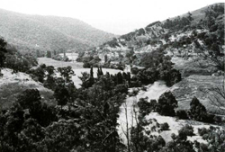 In ridge-and-ravine topography, most drainage channels have little alluvium due to the rate of removal being greater than the rate of deposition. Some of the major river, however, have alluvial terraces as, for example, can be seen along the Wonnangatta River where it traverses Talbotville land system. |
| Several vegetation types are found due to the wide geographic and elevation range. Woodland I and II dominate on the drier slopes while open forest I and II are found in more humid areas, notably on protected slopes at higher elevations. | ||
| CLIMATE Rainfall, mean (mm) Temperature, mean (°C) Seasonal growth limitations |
Annual 800 - 1400; lowest January or February (40 - 80), highest October (100 - 150) Annual 8 - 12; lowest July (3 - 7), highest February (16 - 20) Temperature <10°C (av.): April - October Rainfall < potential evapotranspiration: December - February; occasional winter snow |
| GEOLOGY Age, lithology |
Ordovician, Silurian and Devonian mudstones, siltstones, sandstones and shales, occasionally metamorphosed |
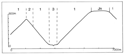
| PHYSIOGRAPHY Landscape Elevation range (m) Relative relief (m) Drainage pattern Drainage density (km/km2) |
Steep mountains with ridge-and-ravine topography 80 - 1300 120 - 720 Dendritic 2.0 |
| PRESENT LAND USE |
|
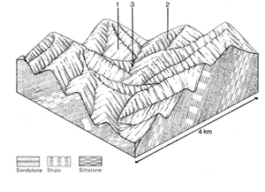 |  |
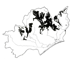
| LAND COMPONENT Percentage of land system Diagnostic features | 1 85 Slopes with drier woodland and forest | 2 10 Slopes with more humid forest, usually on protected upper slopes | 3 5 Discontinuous narrow terraces and, rarely, old terrace remnants along major drainage corridors |
| PHYSIOGRAPHY Slope %, typical and (range) Slope shape | 35 - 45, (25 - 100) Straight | 35 - 45, (25 - 100) Straight | <5, (0 - 10) Straight but uneven |
| SOIL | |||
| Parent material | Mudstone, siltstone, sandstone and shale | Mainly locally derived alluvium | |
| Description | Dark clay loam to loamy sand grading into yellowish or reddish brown similar or heavier-textured subsoil; shallow to very shallow, stony and acidic | As in component 1, but topsoil tends to be darker coloured and somewhat deeper | Mainly little differentiated sandy loam to sandy clay loam; gradational or duplex soils on old terrace remnants |
| Classification | Lithosols, some Red and Brown Earths Um 1.42, Urn 1.43. Um6.13, Um4.31, Gn2.11, Gn2.61, Uc5.11, Uc5.21 | Lithosols, minor Brown Earths and Red Podzolic Soils Um6.12, Um4.22, Gn4.14 | Alluvial Soils, Yellow Earths; Yellow Podzolic Soils on old terrace remnants Uc4.22, Uc4.31, Gn4.81, Dy3. - |
| Surface texture | Clay loam to loam, less commonly lighter textures | Loamy sand to sandy clay loam | |
| Surface consistence | Slightly hard when dry friable when moist | Varies with texture | |
| Depth (m) | <0.8, but commonly<0.5 | >2.0 | |
| Nutrient status | Low | Low | |
| Available soil water capacity | Low to moderate | Low to moderate | |
| Perviousness to water | Moderate | Moderate | |
| Drainage | Good | Varies with position in landscape | |
| Exposed stone (%) | 5 -60 | 0; high on ancient gravel deposits | |
| Sampled profile number | 11 | - | - |
| NATIVE VEGETATION Structure of vegetation and characteristic species of dominant stratum (+ Predominant species) | Because of wide geographic and altitudinal range, varies from woodland I to open forest II, often shrubby or grassy: E. bridgesiana, E. dives, E. goniocalyx, E. melliodora, or E. sieberi usually predominant; E. rubida, E. macrorhyncha, E. pauciflora (at higher elevations) Rarely closed forest in minor drainage corridors: Acmena smithii+ with climbers, ferns and epiphytes | Open forest II, III, often shrubby: E. viminalis, E. radiata or E. goniocalyx usually predominant; E. macrorhyncha and, on old terrace remnants, E. cephalocarpa associated | |
|
|
|
|
| ||
|
|
| ||||
— reduction in leaf area, rooting depth and/or perenniality — reduction in density of tree roots |
resulting in: a) increased deep percolation b) increased regolith wetness Decreased root-binding |
Nutrient loss Landslip and soil creep Landslip and soil creep |
Not determined 1; moderate 2; high 1; moderate 2; high |
determined Common on steep slopes Common on steep slopes |
Removal of trees Accelerated by major disturbance to native vegetation Accelerated by major disturbance to native vegetation |
Increased movement of water to groundwater; increased base-flow of streams Increased sediment load Increased sediment load |
|
|
|
|
|
earth-moving activities, trafficking by stock |
|
|
With Reduced infiltration |
Sheet and rill erosion |
1,2; high |
Uncommon: local incidence only |
As for sheet and rill erosion above |
Increased flash flows |
|
|
Scour erosion Streambank erosion |
3; high 3; high |
Uncommon Uncommon |
As for sheet and rill erosion above As for sheet and rill erosion above |
Increased sediment load Increased sediment load |
| ||||||
© State of Victoria (Agriculture Victoria) 1996 - .

This work, Victorian Resources Online, is licensed under a Creative Commons Attribution 4.0 licence. You are free to re-use the work under that licence, on the condition that you credit the State of Victoria (Agriculture Victoria) as author, indicate if changes were made and comply with the other licence terms.
The licence does not apply to ‘branding’ or some ‘images or photographs’ that may be owned by third parties. We ask you to seek prior approval to use images using the VRO feedback form. Access to higher quality images can also be provided on request.
This page was last updated on .