
Sandy (Sy)
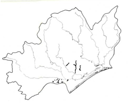 | Area: 41 sq. km (0.2%) All drainage depressions in the Eastern lowlands and Baragwanath Anticline in which sandy alluvium dominates have been mapped in Sandy land system, except for areas with braided channels which are mapped in Stratford land system. This is consequently a very variable land system and most variation is dealt with on a component basis. All components are not always present in any one occurrence of the land system due to differences between streams. Streams have low gradients and at least two terrace levels, except on the Baragwanath Anticline where the downstream slopes are greater. Here there are also springs and seepage areas on the lower slopes. Sandy soils dominate and those above normal flood levels are weakly podzolised with somewhat bleached subsurface horizons and brown subsoils which may be cemented and nodular. In lower lying parts subject to flooding the sands generally are younger with little profile differentiation beyond humus accumulation in the surface. There are some clayey parent materials and these can also differ in degree of soil development depending on flood regime. Duplex soils develop in non-inundated, better-drained areas. In areas which are poorly drained or seasonally flooded, soil development is limited to surface darkening and subsoil mottling. Wind erosion appears to be the main hazard on the sandy soils, as slopes are generally too gentle and soils too permeable for sheet erosion by water. However, the permeable soils are susceptible to leaching. The vegetation is mainly woodland I or II, often shrubby or ferny. | 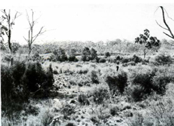 A higher level terrace adjacent to the Perry River |
| CLIMATE Rainfall, mean (mm) Temperature, mean (°C) Seasonal growth limitations | Annual 500 - 800; lowest July (30 - 50), highest October (50 - 80) Annual 12 - 14; lowest July (8 - 10), highest February (19 - 21) Temperature <10°C (av.): June - August Rainfall < potential evapotranspiration: November – March |
| GEOLOGY Age, lithology | Holocene sandy alluvium; minor Tertiary gravels, sands and clays |
| PHYSIOGRAPHY Landscape Elevation range (m) Relative relief (m) Drainage pattern Drainage density (km/km2) | Drainage floors with predominantly sandy alluvium 20 - 120 5 - 20 Meander channel 1.7 |
| PRESENT LAND USE | Mostly cleared: grazing of cattle and sheep on unimproved pastures; softwood plantations (limited) Minor proportion uncleared: apiculture; bush grazing (limited); small area in the Holey Plains State Park |
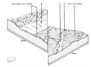 | 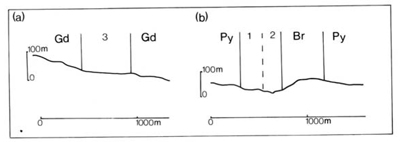 |
| LAND COMPONENT Percentage of land system Diagnostic features | 1 70 High-level linear terraces only inundated by very high floods | 2 15 Lower, narrow modern flood plains | 3 15 Drainage areas sometimes with seepage zones |
| PHYSIOGRAPHY Slope %, typical and (range) Slope shape | 1, (0- 2) Straight | 1, (0- 2) Straight | 1- 2, (0- 3) Straight |
| SOIL | |||
| Parent material | Sandy alluvium | ||
| Description | Deep black sand over greyish brown subsurface soil; dark brown sand or nodular coffee rock subsoil; often strongly acidic throughout | Variable; little differentiated sand to sandy clay loam, black to dark brown at the surface, greyish brown to light yellowish brown at depth; sometimes mottled | Limited observations — variable; sandy soils as in component 1; also dark greyish brown sandy loam over greyish brown mottled sandy loam with abrupt change to blocky yellowish brown clay subsoil |
| Classification | Incipient Podzols, Siliceous Sands Uc2.36, Uc4.23, Uc4.24 | Alluvial Soils Ucl.21, Uc5.23, Um1.41 | Incipient Podzols, Yellow Podzolic Soils Uc2.31, Uc4.- , also Dy2.2- |
| Surface texture | Loamy sand | Loamy sand to sandy or silty clay loam | Sand to sandy loam |
| Surface consistence | Soft when dry | Soft when dry | Soft when dry |
| Depth (m) | >2.0 | >2.0 | >2.0 |
| Nutrient status | Very low | Very low to low | Very low to low |
| Available soil water capacity | Very low | Very low to moderate | Very low to moderate |
| Perviousness to water | Very rapid | Slow to very rapid | Slow to very rapid |
| Drainage | Excessive | Somewhat poor to good | Somewhat poor to good |
| Exposed stone (%) | 0 | 0 | 0 |
| Sampled profile number | - | - | - |
| NATIVE VEGETATION Structure of vegetation and characteristic species of dominant stratum (+ Predominant species) | Ferny or shrubby woodland II: E. consideniana+ or E. viminalis var. racemosa+ | Limited data — probably woodland II or open forest II, often shrubby with E. globoidea+ or with E. ovata+ and E. tereticornis | Mainly shrubby woodland I, II: Species include E. radiata+, E. bridgesiana+ and E. ovata Occasionally closed forest I, II: Melaleuca ericifolia+ |
|
|
|
|
| ||
|
|
| ||||
— reduction in leaf area, rooting depth and/or perenniality |
|
|
2; moderate 3; variable, low - high |
|
|
|
|
|
|
2; low - moderate 3; low |
|
|
|
|
|
|
2; low - moderate |
|
|
|
|
Increased loosening of sand |
Wind erosion |
3; moderate 1; high 2; low - moderate 3; low |
Uncommon |
As for wind erosion above |
Encroachment by sand |
| ||||||
© State of Victoria (Agriculture Victoria) 1996 - .

This work, Victorian Resources Online, is licensed under a Creative Commons Attribution 4.0 licence. You are free to re-use the work under that licence, on the condition that you credit the State of Victoria (Agriculture Victoria) as author, indicate if changes were made and comply with the other licence terms.
The licence does not apply to ‘branding’ or some ‘images or photographs’ that may be owned by third parties. We ask you to seek prior approval to use images using the VRO feedback form. Access to higher quality images can also be provided on request.
This page was last updated on .