
Stratford (Sd)
 | Area: 33 sq. km (0.2%) Changes have occurred in the stability of some rivers resulting in alterations to stream form. The changes seem to have occurred since European settlement along rivers where dams, capable of flood control, do not exist upstream, and where the alluvial materials are sandy. The initiating cause is unclear. Change in stream form is most obvious along the Avon River where lateral migration and active streambank erosion have occurred and a new sandy or gravelly terrace level is being constructed. The river has acquired a considerable bedload from the eroding banks and a braided condition has developed. The terraces and braiding channels are mapped in Stratford land system. | 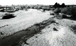 The gravelly bed and braided channels of the Avon River near Stratford |
| The only `soils' in Stratford land system are the sands on the terraces. Many of these have not undergone significant pedological development since deposition and are likely to be shifted by strong flows before soil development can take place. In some parts, however, the surfaces have become darker due to accumulation of organic matter. The non-terrace areas are characterised by gravel and moving water. Wind erosion may occur on the sandy soils but the presence of moisture at shallow depth tends to reduce their susceptibility. Streambank erosion is a natural feature though this mainly affects the adjacent Maffra 1, 2 or Valencia land systems. The area now supports a shrubby grassland of mixed native and exotic species. | ||
| CLIMATE Rainfall, mean (mm) Temperature, mean (°C) Seasonal growth limitations |
Annual 500 - 800; lowest July (30 - 50), highest October (50 - 80) Annual 12 - 14; lowest July (8 - 10), highest February (19 - 21) Temperature <10°C (av.): June - August Rainfall < potential evapotranspiration: November – March |
| GEOLOGY Age, lithology |
Holocene alluvium, re-worked from older deposits |
| PHYSIOGRAPHY Landscape Elevation range (m) Relative relief (m) Drainage pattern Drainage density (km/km2) |
Braiding river channels and sandy alluvial terraces 80 0 - 5 Braided meander channel 2.5 |
| PRESENT LAND USE |
|
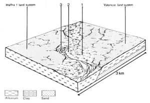 | 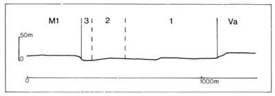 |
| LAND COMPONENT Percentage of land system Diagnostic features | 1 60 Flood-sculptured sandy terraces | 2 25 Gravelly, stony point bars and interchannel areas | 3 15 Braided channels, including steep river banks |
| PHYSIOGRAPHY Slope %, typical and (range) Slope shape | <2, (0 - 5) Mainly convex and uneven | 2, (0 - 5) Mainly convex and uneven | <2, (0 - 5) steeply eroding banks Concave |
| SOIL | |||
| Parent material | Alluvial sand and minor gravel | Alluvial gravel | - |
| Description | Undifferentiated stratified sand and gravelly sand brown at the surface, greyish brown at depth | Undifferentiated gravels — no soils have formed | No soils |
| Classification | Alluvial Soils Uc1.23 | - | - |
| Surface texture | Sand to loamy sand | - | - |
| Surface consistence | Soft when dry | - | - |
| Depth (m) | >2.0 | - | - |
| Nutrient status | Very low | - | - |
| Available soil water capacity | Very low | - | - |
| Perviousness to water | Very rapid | - | - |
| Drainage | Excessive | - | - |
| Exposed stone (%) | Mostly 0 | 100 | - |
| Sampled profile number | 17 | - | - |
| NATIVE VEGETATION Structure of vegetation and characteristic species of dominant stratum (+ Predominant species) (*Introduced species) | Shrubby grassland with scattered trees: *Salix spp., Acacia mearnsii, Hymenanthera dentata, *Rubus spp, Phragmites communis and other grasses, Cyperaceae, and Juncaceae | ||
|
|
|
|
| ||
|
|
| ||||
— reduction in leaf area, rooting depth and/or perenniality |
resulting in increased deep percolation and leaching |
|
|
|
|
|
|
|
|
|
|
|
|
|
|
|
|
|
and export of organic matter |
|
|
Increased soil break-up |
Scour erosion Streambank erosion |
1,2,3; high 3; high |
Common: severe and widespread
widespread |
As for sheet and rill Erosion As for sheet and rill erosion |
Increased sediment load in streams and sedimentation in lakes. Increased sediment load in streams and sedimentation in lakes. |
| ||||||
© State of Victoria (Agriculture Victoria) 1996 - .

This work, Victorian Resources Online, is licensed under a Creative Commons Attribution 4.0 licence. You are free to re-use the work under that licence, on the condition that you credit the State of Victoria (Agriculture Victoria) as author, indicate if changes were made and comply with the other licence terms.
The licence does not apply to ‘branding’ or some ‘images or photographs’ that may be owned by third parties. We ask you to seek prior approval to use images using the VRO feedback form. Access to higher quality images can also be provided on request.
This page was last updated on .