
Reynard (Rd)
 | Area: 43 sq. km (0.2%) Undulating to domed mountain peaks and ridges at very high elevations, comparable with those of Hotham land system, have been mapped as Reynard land system. These broad, concave slopes occur on resistant rocks such as quartzites of the Carboniferous Snowy Plains Formation and the Wellington Rhyolites. The mountain peaks are usually treeless. In addition, radially-oriented, treeless corridors, normal to contour, have formed from concentrated movement of low-temperature snowmelt. On sedimentary rocks these corridors are often diverted laterally by rock structure. Rock outcrop and peat bogs are common, and some solifluction lobes occur. Resistant parent rock, low temperatures and high rainfall combine to produce soils which are relatively shallow, friable and acidic, with very high concentrations of organic matter in the topsoil and with little textural change down the profile. In spite of excellent infiltration characteristics, significant surface run-off can occur when the subsoil is frozen. | 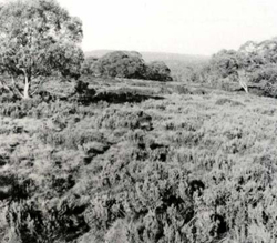 Gentle slopes of component 2 with a mixture of shrubs, grasses and herbs |
| Woodlands, often shrubby, grow on the slopes, domes and rocky crests. Tussock grasslands and open heath occur at the higher elevations, in the more exposed positions and on the treeless corridors radiating downslope. Peat bogs are found on sites with poor drainage. | ||
| CLIMATE Rainfall, mean (mm) Temperature, mean (°C) Seasonal growth limitations |
Annual 900 - 1600; lowest January or February (70 - 100), highest August or September (150 - 180) Annual 4 - 8; lowest July (-2 - 0), highest February (11 - 13) Temperature <10°C (av.): April - October Rainfall < potential evapotranspiration: February; frequent winter snow |
| GEOLOGY Age, lithology |
Resistant rocks, such as quartzites of the Carboniferous Snowy Plains Formation and parts of the Devonian Wellington Rhyolites |
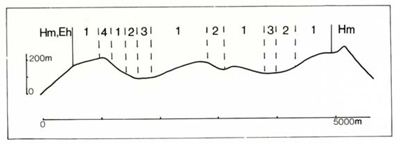
| PHYSIOGRAPHY Landscape Elevation range (m) Relative relief (m) Drainage pattern Drainage density (km/km2) |
Broad convex slopes and undulating to domed mountain peaks and ridges 1360 - 1700 100 - 260 Radial 0.9 |
| PRESENT LAND USE |
|
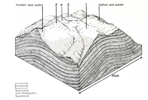 |  |
| LAND COMPONENT Percentage of land system Diagnostic features | 1 60 Domes and wooded slopes with treeless corridors radiating down slope | 2 20 Treeless slopes and saddles | 3 10 Rocky crests | 4 10 Structurally controlled soaks and peat bogs, often drained by small streams |
| PHYSIOGRAPHY Slope %, typical and (range) Slope shape | 5 - 10, (0 - 15) Convex | 5 - 10, (0 - 15) Convex | Variable, (0 - 10) Convex | <1, (0 - 2) Concave |
| SOIL | ||||
| Parent material | Quartzite and rhyolite | Alluvium | ||
| Description | Shallow profiles with friable black or very dark, organic sandy loam to sandy clay loam, merging into dark brown or dark greyish brown sandy loam to sandy clay loam. May be stony at depth | Shallow black peat or muck over mineral soil | ||
| Classification | Alpine Humus Soils/Brown Earths Um6.23, Um5.51, Gn2.41 | Humic Gleys, Acid Peats - | ||
| Surface texture | Sandy loam to sandy clay loam | - | ||
| Surface consistence | Soft to slightly hard | - | ||
| Depth (m) | 0.3 - 0.9 | >2.0 | ||
| Nutrient status | Low to moderate | Very low | ||
| Available soil water capacity | Moderate to high | Very high | ||
| Perviousness to water | Moderate to rapid | Moderate | ||
| Drainage | Good | Very poor | ||
| Exposed stone (%) | Variable; 0 - 20 | <60 | ||
| Sampled profile number | - | - | - | - |
| NATIVE VEGETATION Structure of vegetation and characteristic species of dominant stratum (+ Predominant species) | Woodland I: E. pauciflora+ Treeless slopes and domes a mosaic of tussock grassland with Poa spp. and open heath with Oxylobium alpestre+ and Hovea longifolia+ | Tussock grassland: Poa spp., Celmisia asteliifolia Open heath: O. alpestre, H. longifolia | Shrubby woodland I: E. pauciflora Open heath: O. alpestre, H. longifolia Minor tussock grassland: Poa spp. | Bog: Baeckea gunniana+, Calorophus lateriflorus+, Sphagnum sp.+ |
|
|
|
|
| ||
|
|
| ||||
— reduction in leaf area, rooting depth and/or perenniality — reduction in density of tree roots |
resulting in: a) increased deep percolation b) decreased fog drip c) increased rate of snow melt d) increased depth of soil freezing |
Nutrient loss - - Solifluction |
Not determined - - 1; low |
Not determined - - Not determined |
Removal of trees Removal of trees Removal of trees Removal of trees |
Increased movement of water to groundwater; increased base-flow of streams Reduced base flow of steams Increased spring and decreased summer stream flow - |
|
Increased frost heave and soil detachment |
Wind sheet and rill erosion |
1,2,3; moderate |
Not determined |
|
and sediment load |
|
With Reduced infiltration |
Sheet and rill erosion |
4; high 1,2,3; low |
Not determined |
As for sheet and rill erosion above |
Increased flash flows |
|
|
|
|
|
erosion above |
|
| ||||||
© State of Victoria (Agriculture Victoria) 1996 - .

This work, Victorian Resources Online, is licensed under a Creative Commons Attribution 4.0 licence. You are free to re-use the work under that licence, on the condition that you credit the State of Victoria (Agriculture Victoria) as author, indicate if changes were made and comply with the other licence terms.
The licence does not apply to ‘branding’ or some ‘images or photographs’ that may be owned by third parties. We ask you to seek prior approval to use images using the VRO feedback form. Access to higher quality images can also be provided on request.
This page was last updated on .