
Hotham (Hm)
 | Area: 309 sq. km (1.5%) Steep mountainous terrain with ridge-and-ravine topography in the alpine and subalpine tracts is mapped in Hotham land system. Lithology varies and mountain peaks tend to be acute on Ordovician, Devonian and Silurian sediments and steeply domed on the Wellington Rhyolites and quartzites of the Snowy Plains Formation. Rocky outcrops and rockslides are common and at higher elevations solifluction lobes occur. |  Exposed slopes, crests and scarps with open heath, herbfield and tussock grassland in the Mount Speculation area. |
Active slope processes, a cold climate and high precipitation tend to produce soils which are shallow, stony, friable and acidic with very high concentrations of organic matter in the topsoil and with little textural change down the profile. Slopes facing south-east and east appear to have the shallowest soils. Deeper soils, including remnants of old soil mantles, have been observed on north- and west-facing slopes. These soils have excellent infiltration characteristics but saturation at the surface and run-off can occur when the subsoil is frozen. Both surface erosion and slow, shallow mass movement (solifluction) can occur under these circumstances. Disturbance of the highly organic topsoil by mechanical processes, such as the freeze/thaw of ice or by trampling, followed by drying can render it fluffy and vulnerable to wind erosion. Most of the area is in the subalpine tract and carries a shrubby woodland I. On lower, more-protected sites or on areas that have been recently fired, the woodland may be replaced by shrubby open forest I or II or, in more exposed areas, by tussock grassland or open heath. Alpine herbfield occurs along with open heath and tussock grassland in the alpine tract. | ||
| CLIMATE Rainfall, mean (mm) Temperature, mean (°C) Seasonal growth limitations | Annual 900 - 1600; lowest January or February (70 - 100), highest August or September (150 - 180) Annual 4 - 8; lowest July (-2 - 0), highest February (11 - 13) Temperature <10°C (av.): April - October Rainfall < potential evapotranspiration: February; frequent winter snow |
| GEOLOGY Age, lithology | Variable; commonly Ordovician, Silurian and Devonian sandstones and shales; Carboniferous siltstones; Devonian rhyolites and some basalts |
| PHYSIOGRAPHY Landscape Elevation range (m) Relative relief (m) Drainage pattern Drainage density (km/km2) | Steep mountains with ridge-and-ravine topography 1100 - 1860 80 - 540 Dendritic 0.6 |
| PRESENT LAND USE | Uncleared: summer bush grazing of cattle; apiculture (limited); recreation — bushwalking, skiing |
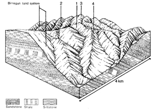 | 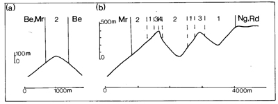 |
| LAND COMPONENT Percentage of land system Diagnostic features | 1 45 Exposed wooded slopes | 2 40 Less exposed forested slopes | 3 10 Treeless peaks and crests | 4 5 Scarps and rockslides |
| PHYSIOGRAPHY Slope %, typical and (range) Slope shape | 30 - 50, (20 - 80) Straight | 30 - 50, (20 - 80) Straight | 10 - 25, (0 - 50) Convex or straight | -, (>60 - occasionally vertical) Straight |
| SOIL | ||||
| Parent material | Variable; sandstone, shale, some rhyolite and basalt | |||
| Description | Commonly shallow and stony; friable black or very dark organic loamy sand to sandy clay loam merging into dark brown or dark greyish brown loamy sand to sandy clay loam | Rock outcrops and very stony soils | ||
| Classification | Lithosols, Alpine Humus Soils Uc1.44,Urn 1.44, Um6.11, Um6.21, Um6.24, Um6.42 | Lithosols - | ||
| Surface texture | Variable, depends on parent rock; loamy sand to sandy clay loam | |||
| Surface consistence | Soft to slightly hard | |||
| Depth (m) | 0.1 - 0.6(generally) | |||
| Nutrient status | Low to moderate | |||
| Available soil water capacity | Moderate to high | |||
| Perviousness to water | Moderate to rapid | |||
| Drainage | Good | |||
| Exposed stone (%) | Extremely variable; commonly 30 - 60 | >60 (generally) | ||
| Sampled profile number | - | - | - | - |
| NATIVE VEGETATION Structure of vegetation and characteristic species of dominant stratum (+ Predominant species) | Woodland I: E. pauciflora+, occasionally with E. rubida | Shrubby open forest I, II: E. pauciflora+ and/or E. rubida+ | Predominantly tussock grassland of Poa spp. with open heath on drier sites Alpine tract with open herbfield and, in eroded areas, feldmark of Ewartia nubigena | Mosaic of tussock grassland with Poa spp. and open heath of Hovea longifolia+, Oxylobium alpestre+ and O. ellipticum+ |
Disturbance | Affected process and trend | Primary resultant deterioration | Casual activities | Primary off-site process | ||
Form | Susceptibility of components | Incidence with components | ||||
— reduction in leaf area, rooting depth and/or perenniality |
resulting in: a) increased deep percolation b) decreased fog drip c) increased rate of snow-melt d) increased depth of soil freezing |
Nutrient loss - - Solifluction |
Not determined - - 1,2; low |
Not determined Not determined Not determined
|
Removal of trees Usually after the removal of native vegetation Usually after the removal of native vegetation Usually after the removal of native vegetation |
Increased movement of water to groundwater; increased base-flow of streams Decreased stream base flow Increased spring and decreased summer - |
|
Increased overland flow and soil detachment |
Sheet and rill erosion |
2; low 1,2,3; moderate |
Common |
Burning, road and other earth-moving activities, trafficking by stock and humans |
Increased overland flows, flash flows and sediment load |
|
With Reduced infiltration |
Sheet and rill erosion |
1,2,3; moderate |
Common |
As for sheet and rill erosion above |
Increased flash flows |
|
|
|
|
|
|
|
| ||||||
© State of Victoria (Agriculture Victoria) 1996 - .

This work, Victorian Resources Online, is licensed under a Creative Commons Attribution 4.0 licence. You are free to re-use the work under that licence, on the condition that you credit the State of Victoria (Agriculture Victoria) as author, indicate if changes were made and comply with the other licence terms.
The licence does not apply to ‘branding’ or some ‘images or photographs’ that may be owned by third parties. We ask you to seek prior approval to use images using the VRO feedback form. Access to higher quality images can also be provided on request.
This page was last updated on .