
Nuntin (Nt)
 | Area: 38 sq. km (0.2%) This small land system occurs in what were probably the downstream parts of prior stream systems on the later Pleistocene terrace. Raised alluvial ridges of generally sandy materials alternate with clay flats. Bedding layers are clearly evident in some of the sandier deposits south-west of Sale. East of Sale the deposits tend to be medium-textured and near Lake Wellington they merge with the sand deposits of Clydebank land system. Some aeolian deformation of the sandier deposits has occurred. Fine sediments dominate but there are areas of sands. Generally the materials are of Holocene age and have undergone little soil formation beyond the accumulation of organic matter in the topsoil and the development of mottles in the less well-drained subsoils. The deeper subsoils tend to be neutral or alkaline in reaction but the topsoils have been sufficiently leached to be moderately or mildly acidic. | 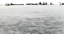 A very gently undulating plain, the predominant terrain of Nuntin land system |
| As the groundwater generally occurs between 1 and 2 m below the surface, and tends to be moderately to highly saline, there is a moderate salinity hazard. The native vegetation, probably an E. tereticornis grassy woodland II, or ferny woodland II on deeper sands, has been almost entirely removed. | ||
| CLIMATE Rainfall, mean (mm) Temperature, mean (°C) Seasonal growth limitations | Annual 500 - 800; lowest July (30 - 50), highest October (50 - 80) Annual 12 - 14; lowest July (8 - 10), highest February (19 - 21) Temperature < 10°C (av.): June - August Rainfall < potential evapotranspiration: November – March |
| GEOLOGY Age, lithology | Upper Pleistocene alluvial and some aeolian sand deposits |
| PHYSIOGRAPHY Landscape Elevation range (m) Relative relief (m) Drainage pattern Drainage density (km/km2) | Alluvial rises, occasionally with aeolian deformation, and intervening clay floors 0 - 20 0 - 5 Dendritic 0.3 |
| PRESENT LAND USE | Cleared: grazing of cattle and sheep; mining of sand deposits |
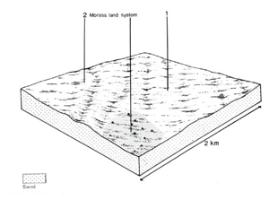 |  |
| LAND COMPONENT Percentage of land system Diagnostic features | 1 60 Gently undulating plains | 2 40 Rises, often dune-like |
| PHYSIOGRAPHY Slope %, typical and (range) Slope shape | 1 - 2, (0 - 4) Various | 3 - 5, (0 - 8) Convex |
| SOIL | ||
| Parent material | Alluvium of variable texture and aeolian sand | |
| Description | Variable; greyish brown siliceous sand over buried clay; black to dark greyish brown clay loam, light clay or lighter textured topsoil grading into mottled brown or grey clay subsoil; may be calcareous | Single observation — greyish brown sand or loamy sand becoming more reddish brown or yellowish red with depth. Soils possibly calcareous |
| Classification | Wiesenboden, Siliceous Sands Gn3.23, Gn4.53, Gn4.82, Um2.21, Uc4.32, Uc5.23 | Alluvial Soils Uc1.23 |
| Surface texture | Variable | Sand or loamy sand |
| Surface consistence | Variable | Soft or loose when dry, friable when moist |
| Depth (m) | >2.0 | >2.0 |
| Nutrient status | Moderate, sometimes low | Low |
| Available soil water capacity | Moderate, sometimes low | Low |
| Perviousness to water | Moderate to rapid | Rapid |
| Drainage | Somewhat poor | Good |
| Exposed stone (%) | 0 | 0 |
| Sampled profile number | 20 | - |
| NATIVE VEGETATION Structure of vegetation and characteristic species of dominant stratum (+ Predominant species) | Grassy woodland II or, on deeper sands, ferny woodland II: E. tereticornis+ | |
Disturbance | Affected process and trend | Primary resultant deterioration | Casual activities | Primary off-site process | ||
Form | Susceptibility of components | Incidence with components | ||||
- reduction in leaf area, rooting depth and/or perenniality |
a) increased deep percolation and leaching b) raised saline groundwater table |
Nutrient loss Salting |
1; low 2; moderate 1; moderate |
Not determined Common |
Removal of trees Removal of trees |
Increased movement of water to groundwater; increased base-flow streams Increased movement of water to groundwater; increased base-flow streams |
|
|
|
|
|
|
|
|
With Reduced infiltration |
Waterlogging |
1; moderate |
Common |
As for structure decline above |
Increased ponding of water in lower areas |
|
|
|
|
|
|
|
| ||||||
© State of Victoria (Agriculture Victoria) 1996 - .

This work, Victorian Resources Online, is licensed under a Creative Commons Attribution 4.0 licence. You are free to re-use the work under that licence, on the condition that you credit the State of Victoria (Agriculture Victoria) as author, indicate if changes were made and comply with the other licence terms.
The licence does not apply to ‘branding’ or some ‘images or photographs’ that may be owned by third parties. We ask you to seek prior approval to use images using the VRO feedback form. Access to higher quality images can also be provided on request.
This page was last updated on .