
Clydebank (Ck)
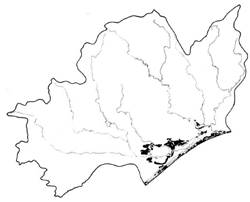 | Area: 163 sq. km (0.8%,) Plains formed by the exposure of lake floors, surround the Gippsland Lakes and are in Clydebank land system. Exposure of the old lake floors developed in various ways, including sea level change, tilting and a slight lowering of lake-level following breaching of the outer harrier at Lakes Entrance. The plains are dominantly sandy and contain some low dunes, swamps and clay flats. Some of the swamps and flats are saline. The low areas may he temporarily inundated during high floods, greatly reducing flooding of other areas further downstream. | 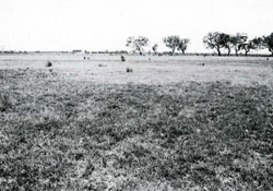 Remnants of woodland on sandy flats |
| The plains appear to have deep, acidic, sandy soils, with groundwater tables between one and two metres depth. The upper horizons have accumulated organic matter and have been leached. Soft, incipient humus- and iron-cemented horizons can be found in the subsoils, where they are probably forming above water table. The sands on the low dunes appear to be young and the accumulation of organic matter at the surface is the only soil development. On the silty and clayey plains, the soils have also accumulated considerable organic matter and show much subsoil or whole-profile mottling, indicative of poor drainage. Lime is sometimes evident in these subsoils and is probably derived from marine shells. The drier sands of the dunes are susceptible to wind erosion. Salinity hazard is high because of shallow groundwater and moderate to high, groundwater salinity. Prior to clearing, most of this country supported a grassy woodland I or ferny open woodland I, with a tussock grassland nearer the lake margins. Swamps, bordered by closed scrub, grow sedgeland and nearer the centre. herbfield. | ||
| CLIMATE Rainfall, mean (mm) Temperature, mean (°C) Seasonal growth limitations |
Annual 500 - 800); lowest July (30 - 50), highest October (50 - 80) Annual 12 - 14; lowest July (8 - 10), highest February (19 - 21) Temperature <10°C (av.): No months Rainfall < potential evapotranspiration: November – March |
| GEOLOGY Age, lithology |
Holocene lacustrine sand and some silts and clays |
| PHYSIOGRAPHY Landscape Elevation range (m) Relative relief (m) Drainage pattern Drainage density (km/km2) |
Plains with low dunes, swamps and clay flats 0 - 20 0 - 5 Deranged 0 |
| PRESENT LAND USE |
Minor proportion uncleared: recreation — fishing and shooting (swamps); areas in Gippsland Lakes Coastal Park and Blond Bay State Game Reserve |
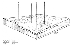 | 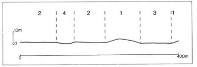 |
| LAND COMPONENT Percentage of land system Diagnostic features | 1 15 Low dunes | 2 65 Flats with deep sandy soils, often with high water tables | 3 15 Flats with silty or clayey soils, sometimes brackish | 4 5 Swamps in relict channels (too small to map as Morass land system) |
| PHYSIOGRAPHY Slope %, typical and (range) Slope shape | 3 - 7, (0 - 15) Convex | 1, (0 - 2) Straight | 1, (0 - 2) Straight | 1, (0 - 1) Concave to straight |
| SOIL | ||||
| Parent material | Wind-sorted sand | Sands, often finer than in component 1 | Lacustrine silt and clay | |
| Description | Limited observations — black sand topsoil; brown sand subsoil becoming light yellowish brown at depth | Limited observations — black sand grading into grey sand over yellowish brown cemented sand | Black organic silty loam to light clay grading into strongly mottled brown to olive brown or grey clay subsoil; subsoil alkaline, sometimes calcareous | Soils as for Morass land system components 1.2 and 3 |
| Classification | Siliceous Sands Uc l.43 | Incipient Podzols Uc2.21 | Wiesenboden, Humic Gleys Gn3.43, Gn3.93, Um6.21. Uf6.33 | |
| Surface texture | Sand | Sand | Silty loam to clay | |
| Surface consistence | Friable to firm when moist | Friable when moist | Slightly hard to very hard when dry | |
| Depth (m) | >2.0 | >2.0 | >2.0 | |
| Nutrient status | Very low | Very low | Moderate | |
| Available soil water capacity | Moderate | Moderate | Moderate to high | |
| Perviousness to water | Rapid | Rapid | Slow | |
| Drainage | Good | Poor to somewhat poor | Poor to somewhat poor | |
| Exposed stone (%) | 0 | 0 | 0 | |
| Sampled profile number | - | - | 41 | |
| NATIVE VEGETATION Structure of vegetation and characteristic species of dominant stratum (+ Predominant species) | Mainly ferny open woodland I of K. viminalis var. racemosa+ and Pteridium esculentum with or without Banksia serrata On dunes adjacent to lakes, grassy woodland I or open woodland I of E. tereticornis | Mainly grassy open woodland I of E. tereticornis or E. botryoides (in east) and/or Banksia integrifolia (usually near coast) Some open woodland I of E. ovata and ferny open woodland I typical of component I. Minor tussock grassland of Poa poiformis | Vegetation cleared — probably grassy open woodland I, II of E. tereticornis | Vegetation as for Morass land system |
Disturbance | Affected process and trend | Primary resultant deterioration | Casual activities | Primary off-site process | ||
Form | Susceptibility of components | Incidence with components | ||||
— reduction in leaf area, rooting depth and/or perenniality |
resulting in: a) increased deep percolation and leaching b) rising, saline groundwater table |
Nutrient loss Salting |
1; high 2; low 2,3; moderate 4; high |
Not determined Common; west of Lake Wellington |
Removal of trees Reduced water-use by plants within catchment |
Increased movement of water to groundwater; increased base-flow of streams Increased waterlogging/salting in lower areas |
|
|
|
2; low |
|
|
|
|
With reduced infiltration |
Sheet erosion |
2,3,4; moderate - high 3,4; low |
Uncommon |
As for sheet and rill erosion above |
Increased ponding of water in lower areas |
|
|
|
2; low |
|
|
|
| ||||||
© State of Victoria (Agriculture Victoria) 1996 - .

This work, Victorian Resources Online, is licensed under a Creative Commons Attribution 4.0 licence. You are free to re-use the work under that licence, on the condition that you credit the State of Victoria (Agriculture Victoria) as author, indicate if changes were made and comply with the other licence terms.
The licence does not apply to ‘branding’ or some ‘images or photographs’ that may be owned by third parties. We ask you to seek prior approval to use images using the VRO feedback form. Access to higher quality images can also be provided on request.
This page was last updated on .