
Moe (Mo)
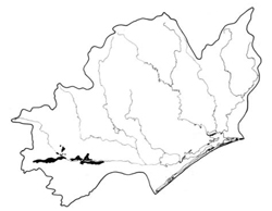 | Area: 86 sq. km (0.5%) Moe land system occurs on almost flat plains in the humid part of the Western Lowlands, mainly beside the Moe River, and in small areas further east. The plains were laid down in a formerly paludal situation in the Moe Sunklands. Gleying and mottling are common in the deeper sediments and deep percolation is poor in contrast to that of the adjacent Trafalgar land system. Sources of the sediment include basic volcanics and Cretaceous rocks. There is much evidence to suggest that the soils to the west of Moe township have been modified by artificial drainage. It seems that the flats were originally swampy with many substantial accumulations of peat. Channel construction lead to a fall in the water table and a reduction in waterlogging. The change to aerobic conditions which was exacerbated by cropping, oxidised much of the peat and organic matter in the topsoils. To the east of Moe, the plains are above the modern flood levels and peats may always have been absent. Most soils now have an accumulation of organic matter in the topsoil, uniform or gradational profiles and mottled subsoils. The native vegetation, probably mainly an open forest II or III dominated by E. ovata, has been almost entirely cleared. | 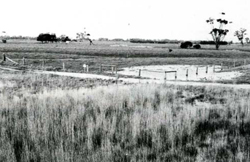 Ponding of water is common in depressions and poorly drained areas of the Moe River flood plain. |
| CLIMATE Rainfall, mean (mm) Temperature, mean (°C) Seasonal growth limitations | Annual 700 - 1200; lowest January or February (40 - 70), highest August or October (90 - 120) Annual 12 - 14, lowest July (8 - 10), highest February (19 - 21) Temperature <10°C (av.): June - August Rainfall < potential evapotranspiration: November – March |
| GEOLOGY Age, lithology | Holocene sediments, mostly silts and clays |
| PHYSIOGRAPHY Landscape Elevation range (m) Relative relief (m) Drainage pattern Drainage density (km/km2) | Almost flat plains 20 - 80 0 - 5 Dendritic 0.8 |
| PRESENT LAND USE | Cleared: grazing of beef and dairy cattle on improved pastures: apiculture |
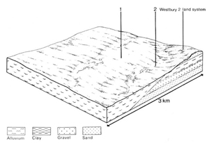 | 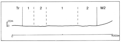 |
| LAND COMPONENT Percentage of land system Diagnostic features | 1 80 Very gently sloping plains | 2 20 Almost flat or slightly depressed plains, poorer drainage |
| PHYSIOGRAPHY Slope %,typical and (range) Slope shape | 1 - 3, (1 - 5) Straight | <1, (0 - 2) Straight, some slightly concave |
| SOIL | ||
| Parent material | Silt, clay and organic matter mostly deposited in a paludal environment | |
| Description | Very dark greyish brown to black silty loam to silty clay loam topsoil, sometimes quite peaty grading into black, grey to light yellowish brown, strongly mottled clay subsoil. Subsoil massive or blocky, sometimes with strong shrink/swell capacity; acidic to neutral. No water tables were found at less than 2 m depth in component 1; in component2, depth to water table was often less than 1 m in winter | |
| Classification | Wiesenboden; Humic Gleys and some Acid Peats in component 2 Um4.25, Gn2.81, Gn2.84, Gn3.91, Gn4.64, Dy3.51, O | |
| Surface texture | Silty loam to silty clay loam | |
| Surface consistence | Friable to firm when moist | |
| Depth (m) | >2.0 | |
| Nutrient status | Moderate to high | |
| Available soil water capacity | Moderate to high | |
| Perviousness to water | Slow | |
| Drainage | Poor to somewhat poor | Very poor |
| Exposed stone (%) | 0 | 0 |
| Sampled profile number | 39 | 2 |
| NATIVE VEGETATION Structure of vegetation and characteristic species of dominant stratum (+ Predominant species) | Open forest II, III: E. ovata+, E. viminalis, sometimes with E. radiata associated | Open forest II, often shrubby: Clearing has made it difficult to determine original species — probably mainly E. ovata+, often with understorey of Melaleuca ericifolia |
Disturbance | Affected process and trend | Primary resultant deterioration | Casual activities | Primary off-site process | ||
Form | Susceptibility of components | Incidence with components | ||||
— reduction in leaf area, rooting depth and/or perenniality |
resulting in raised groundwater table |
|
|
|
in the catchment |
ponding in lowest areas |
|
|
|
|
|
building and other earth-moving activities, trafficking by stock and vehicles |
and sediment load |
|
with Reduced infiltration |
Sheet and rill erosion |
1,2; very low |
Uncommon |
As for sheet and rill erosion above |
Increased flash flows |
|
|
Scour erosion |
2; very low |
Uncommon |
As for sheet and rill erosion above |
Increased sediment load |
| ||||||
© State of Victoria (Agriculture Victoria) 1996 - .

This work, Victorian Resources Online, is licensed under a Creative Commons Attribution 4.0 licence. You are free to re-use the work under that licence, on the condition that you credit the State of Victoria (Agriculture Victoria) as author, indicate if changes were made and comply with the other licence terms.
The licence does not apply to ‘branding’ or some ‘images or photographs’ that may be owned by third parties. We ask you to seek prior approval to use images using the VRO feedback form. Access to higher quality images can also be provided on request.
This page was last updated on .