
Trafalgar (Tr)
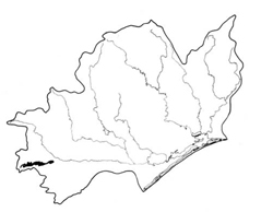 | Area: 65 sq. km (0.4%) Alluvial and colluvial outwash material from the South Victorian Uplands has accumulated in a broad apron in the area between Yarragon and Moe and the area is mapped as the Trafalgar land system. The clayey colluvium was derived mainly from soft, Cretaceous sediments and basic volcanics following uplift of the South Victorian Uplands. Surface drainage is often poor but ochreous colours in deeper layers indicate better drainage at depth. Surface wash still occurs but active colluviation now appears to be minimal. The boundary with the Moe land system is indistinct at the more distal parts. The soils have formed mainly on fine-textured colluvium and alluvium under conditions of seasonal wetness, especially in the low-lying areas receiving run-off and seepage water from adjacent hills. The soils of the higher, more-steeply-sloping areas may dry out completely during summer. | 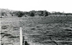 The almost flat distal parts of a colluvial apron below the lower slopes of the Strzelecki Ranges from which the material was derived. The more sloping, proximal parts of the apron are just visible. |
| Mottling is strong in most subsoils and may extend to the surface in places. Moderate nutrient levels are inherited from the source sediments. Erosion hazards are slight but the soils are susceptible to structure decline caused by trafficking and trampling, particularly when wet. The original vegetation, probably dominated by open forest II or III of E. ovata, has been almost entirely cleared. | ||
| CLIMATE Rainfall, mean (mm) Temperature, mean (°C) Seasonal growth limitations | Annual 700 - 1200; lowest January or February (40 - 70), highest August or October (90 - 120) Annual 12 - 14; lowest July (8 - 10), highest February (19 - 21) Temperature <10°C (av.): June - August Rainfall < potential evapotranspiration: November – March |
| GEOLOGY Age, lithology | Pleistocene — Holocene silty and clayey colluvium and alluvium derived from Cretaceous sediments and Tertiary volcanics |
| PHYSIOGRAPHY Landscape Elevation range (m) Relative relief (m) Drainage pattern Drainage density (km/km2) | Low-angle outwash fans and aprons 60 - 800 0 - 5 Dendritic 0.8 |
| PRESENT LAND USE | Cleared: grazing of beef and dairy cattle on improved pasture; some apiculture |
| LAND COMPONENT Percentage of land system Diagnostic features | 1 50 Sloping proximal parts of fans and aprons | 2 40 Almost flat distal parts of fans and aprons | 3 10 Shallow drainage depressions |
| PHYSIOGRAPHY Slope %, typical and (range) Slope shape | 2, (0 - 5) Concave | <1, (0 - 2) Straight to slightly concave | <2, (0 - 2) Concave |
| SOIL | |||
| Parent material | Silty and clayey colluvium and alluvium | ||
| Description | Limited observations — probably mainly very dark greyish brown sandy clay loam to light clay topsoil merging into greyish brown strongly mottled subsoil with texture ranging from silty loam to heavy clay; stratified colluvium or alluvium below. Waterlogging during winter and spring common in components 1 and 2 | ||
| Classification | Wiesenboden; possibly Humic Gleys in component 3 Gn2.81, Gn4.51, Um2.31 | ||
| Surface texture | Sandy clay loam to light clay | ||
| Surface consistence | Friable to firm when moist | ||
| Depth (m) | >2.0 | ||
| Nutrient status | Moderate | ||
| Available soil water capacity | Moderate | ||
| Perviousness to water | Slow | ||
| Drainage | Somewhat poor | Poor to somewhat poor | Very poor |
| Exposed stone (%) | 0 | 0 | 0 |
| Sampled profile number | 43 | - | - |
| NATIVE VEGETATION Structure of vegetation and characteristic species of dominant stratum (+ Predominant species) | Open forest II: E. ovata + Understorey often includes Melaleuca ericifolia or M. squarrosa Clearing has made it difficult to determine other predominant or associated tree species | ||
|
|
|
|
| ||
|
|
| ||||
— reduction in leaf area, rooting depth and/or perenniality |
resulting in raised watertables |
|
2,3; high |
|
|
|
|
|
|
2; very low |
|
|
|
|
With Reduced infiltration |
Sheet and rill erosion |
1; low 2; very low |
Uncommon |
As for sheet and rill erosion above |
Increased ponding in low-lying areas |
|
|
|
2; very low |
|
|
|
| ||||||
© State of Victoria (Agriculture Victoria) 1996 - .

This work, Victorian Resources Online, is licensed under a Creative Commons Attribution 4.0 licence. You are free to re-use the work under that licence, on the condition that you credit the State of Victoria (Agriculture Victoria) as author, indicate if changes were made and comply with the other licence terms.
The licence does not apply to ‘branding’ or some ‘images or photographs’ that may be owned by third parties. We ask you to seek prior approval to use images using the VRO feedback form. Access to higher quality images can also be provided on request.
This page was last updated on .