
Mitchell (Ml)
 | Area: 65 sq. km (0.4%) Some of the valleys in areas with ridge-and-ravine topography are flanked by low spurs and small terrace remnants well above the modern flood plain. The spurs are probably remnants of an earlier, wider valley floor dissected during a phase of more active stream downcutting. The slope gradients, parent rocks, soils and vegetation of these erosional spurs are very similar to those of adjacent lands but the crests tend to be rounded. These spurs and terrace remnants now mainly form meander cores and are mapped in Mitchell land system. Modern flood plains, narrower than those in Walnut land system, are also included, as are some colluvial slopes. On the sedimentary rocks the soils are similar to those on adjacent lands, tending to be shallow, light-textured, yellow or brown coloured, acidic, structureless in the subsoil and stony. On more stable, gentler slopes, the clay content may increase gradually with depth. The remnants of ancient alluvium are likely to have yellowish brown duplex or gradational soils containing much quartz gravel. The modern alluvial deposits have little soil development other than organic matter accumulation and crumb structure formation in the topsoil and the development of reddish or brownish earthy subsoils. The dominant vegetation is open forest II, mainly shrubby, with some grassy open forest II or III on the modern alluvial terraces and fringing major stream channels. | 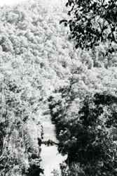 Open forest growing along the Timbarra River somewhat covers the break in slope between the low spurs and relict terraces, diagnostic features of Mitchell land system, and the steep slopes of Carrabungla land system. |
| CLIMATE Rainfall, mean (mm) Temperature, mean (°C) Seasonal growth limitations | Annual 600 - 900; lowest July or August (30 - 50), highest October (50 - 80) Annual 12 - 14; lowest July (8 - 10), highest February (19 - 21) Temperature <10°C (av.): May - September Rainfall < potential evapotranspiration: November – March |
| GEOLOGY Age, lithology | Mainly Ordovician sandstones, siltstones and shales; minor Carboniferous Sediments and Devonian rhyodacites and rhyolites; Holocene sandy alluvium |
| PHYSIOGRAPHY Landscape Elevation range (m) Relative relief (m) Drainage pattern Drainage density (km/km2) | Broad valleys with narrow or discontinuous flood plains flanked by low erosional spurs 120 - 440 20 - 100 Dendritic 3.1 |
| PRESENT LAND USE | Mostly uncleared: hardwood forestry (minor timber products); apiculture Minor proportion cleared: grazing of sheep and cattle |
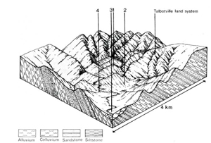 | 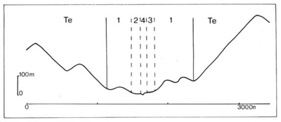 |
| LAND COMPONENT Percentage of land system Diagnostic features | 1 65 Spurs. rocky rises and high terrace remnants, mostly meander cores | 2 15 Lower slopes | 3 15 Terraces | 4 5 Major stream channels |
| PHYSIOGRAPHY Slope %, typical and (range) Slope shape | 15 - 25, (0 - 40) Convex | 10 - 20, (5 - 25) Concave | 2, (0 - 5) Straight but uneven | <1, (0 - 5) Concave |
| SOIL | ||||
| Parent material | Sandstone, siltstone, shale; minor ancient alluvium | Coarse and medium textured colluvium | Mainly coarse textured alluvium | - |
| Description | Limited observations — soil probably mainly similar to that in adjacent land systems, ie. Talbotville 1: Turton 1,2 and Carrabungla 1.2; rarely duplex | Limited observations — probably dark greyish brown sandy to loamy topsoil gradually becoming yellower or browner and more clayey with depth; may be gravelly | Younger terraces: undifferentiated grey or brown sandy loam over stratified alluvium. Older terraces: brown or reddish earthy sandy loam | No soils, only moving alluvial deposits: sand and gravel bedload |
| Classification | Mostly Brown and Yellow Earths, also Lithosols Uc4. - . Uc5. - , Um5. - . Gn2. - | Brown and Yellow Earths Gn2.44 | Alluvial Soils, some Red Earths Ucl.21, Gn2.01, Uc5.21 | - |
| Surface texture | Sandy loam to clay loam | Sandy loam to clay loam | Sand to sandy loam | - |
| Surface consistence | Friable when moist | Friable when moist | Loose to friable when moist | - |
| Depth (m) | Mostly <0.8 | >2.0 | >2.0 | - |
| Nutrient status | Low | Low to moderate | Low | - |
| Available soil water capacity | Low to moderate | Moderate | Low to moderate | - |
| Perviousness to water | Moderate | Moderate | Rapid | - |
| Drainage | Good | Probably very variable | Good | - |
| Exposed stone (%) | 0 - 60 | 0 - 20 | 0 | - |
| Sampled profile number | - | - | - | - |
| NATIVE VEGETATION Structure of vegetation and characteristic species of dominant stratum (+ Predominant species) | Open forest II, sometimes shrubby: Limited data — probably mixed species forests with E. goniocalyx or E. dives predominant. Associated species include E. polyanthemos and E. radiata | Open forest II. sometimes shrubby: E. radiata+ and/or E. stellulata+. Associated species include E. ovata, E. viminalis | Shrubby or grassy open forest II. III: Predominant species variable. usually one or more of E. melliodora, E. viminalis, E. radiata, E. polyanthemos; E. cypellocarpa sometimes associated | Fringing vegetation of shrubby or grassy open forest II, III: Species as in component 3 |
Disturbance | Affected process and trend | Primary resultant deterioration | Casual activities | Primary off-site process | ||
Form | Susceptibility of components | Incidence with components | ||||
— reduction in leaf area, rooting depth and/or perenniality |
|
|
|
|
|
|
|
|
|
3; low |
|
|
|
|
With Reduced infiltration |
Sheet and rill erosion |
1,2; moderate 3; low |
Not determined |
As for sheet and rill erosion above |
Increased flash flows |
|
|
Scour erosion Streambank erosion |
3; high 4: high |
Not determined Not determined |
erosion above As for sheet and rill erosion above As for sheet and rill erosion above |
and turbidity Increased sediment load and turbidity Increased sediment load and turbidity |
| Comments: No observations of deterioration | ||||||
© State of Victoria (Agriculture Victoria) 1996 - .

This work, Victorian Resources Online, is licensed under a Creative Commons Attribution 4.0 licence. You are free to re-use the work under that licence, on the condition that you credit the State of Victoria (Agriculture Victoria) as author, indicate if changes were made and comply with the other licence terms.
The licence does not apply to ‘branding’ or some ‘images or photographs’ that may be owned by third parties. We ask you to seek prior approval to use images using the VRO feedback form. Access to higher quality images can also be provided on request.
This page was last updated on .