
Jeeralang (Jg)
 | Area: 316 sq. km (1.6%) Jeeralang land system occurs on the Cretaceous mudstones, siltstones and sandstones of the South Victorian Uplands. The terrain is mountainous with pronounced ridge-and ravine topography, long steep slopes and shallow soils. Most occurrences are on the elevated Balook Block or along the Yarragon Monocline. Landslides have been an important slope process, probably because of the soft porous nature of the sediments and the history of tectonic activity. This land is geologically and climatically similar to Gunyah land system but has greater relief and elevation, and longer slopes. A cool, humid environment, sedimentary rock that weathers relatively easily and steep slopes have resulted in moderately deep, uniform-textured, silty clay loams to clay loams with a medium to fine blocky structure. Roots are common in the subsoil. These soils are thought to be of higher nutrient status than most other soils on sedimentary parent materials in the survey area. The vegetation is mainly E. regnans layered open forest III with open forest II and III on more exposed aspects or where rainfall is lower. | 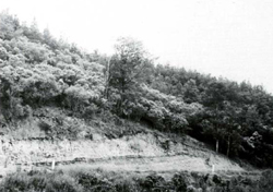 A roadcut through the steep slopes showing the typically shallow soils. |
Rainfall, mean (mm) Temperature Seasonal growth limitations, mean (°C) | Annual 900 - 1600; lowest January (60 - 90), highest August or October (120 - 150) Annual 8 - 12; lowest July (3 - 7), highest February (16 - 20) Temperature <10°C (av.): May - September Rainfall < potential evapotranspiration: December - February; occasional winter snow |
Age, lithology | Cretaceous sandstones, mudstones, siltstones and conglomerates of the Strzelecki Group |
Landscape Elevation range (m) Relative relief (m) Drainage pattern Drainage density (km/km2) | Steep mountains with ridge-and-ravine topography 140 – 700 100 – 360 0.7 |
| Mostly uncleared: hardwood forestry (mainly ash timber); small area in Bulga National Park Minor proportion cleared: grazing of beef and dairy cattle on improved pastures; softwood plantations |
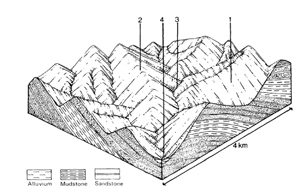 | 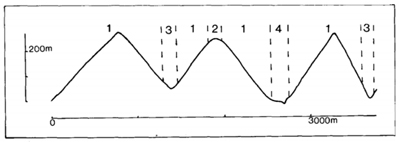 |
Percentage of land system Diagnostic features | 1 85 Steep slopes with old landslide scars common, and narrow rounded crests | 2 5 Broader rounded ridge crests mainly at lower elevations | 3 5 Steeper slopes of gullies and ravines | 4 5 Small flats in the major drainage corridors |
Slope %, typical and (range) Slope shape | 35-45 (30-60) Straight | 5-10 (0-15) Convex | Variable (5-50) Straight | <5 (0-10) Straight |
| ||||
| Mudstone, siltstone and sandstone | Alluvium derived from components 1, 2 and 3 | ||
| Dark greyish brown to silty clay loam to clay loam merging into brown to yellowish brown silty clay; generally moderately deep and somewhat stony | Similar to component 1, but subsoil heavier and mottled | Similar to component 1 | No observations – probably uniformly textured sandy loam to silty loam; some stones and gravel |
| Brown Earths Um6.12, Um6.14, Um6.23, Uf6.12, Gn4.31, Gn4.51 | Brown Earths Gn3.21, Gn4.31 | Brown Earths Um6.12, Um6.14, Um6.23, U6.12, Gn4.31, Gn4.51 | Alluvial Soils (See Gunyah land system) |
| Silty clay to clay loam | Clay loam | Silty clay loam to clay loam | Loam |
| Hard | Hard | Hard | Hard |
| 0.5-1.6 | 1.0-2.0 | 0.5-1.6 | >2.0 |
| Moderate | Moderate | Moderate | Moderate |
| Moderate | Moderate | Moderate | Moderate |
| Moderate to rapid | Moderate to rapid | Moderate to rapid | Moderate to rapid |
| Good | Somewhat poor to good | Good | Good |
| 0 | 0 | 0 | 0 |
| 16 | 38 | - | - |
Structure of vegetation and characteristic species of dominant stratum (+ Predominant species) | Protected aspects, or where rainfall >1100 mm: Layered open forest III: E. regnans More exposed aspects, where rainfall <1100 mm: Open forest II, III: E. obliqua+, E. globulus Imperfectly drained areas with E. ovata | Layered open forest IV with ferns: E. regnans+ with or without E. obliqua, Alsophila australis, Dicksonia antarctica | Shrubby open forest III; E. viminalis+ | |
Disturbance | Affected process and trend | Primary resultant deterioration | Casual activities | Primary off-site process | ||
Form | Susceptibility of components | Incidence with components | ||||
- reduction in leaf area, rooting depth and/or perenniality - reduction in density of tree roots | Reduced transpiration resulting in: a) increased deep percolation b) increased infiltration and regolith wetness Decreased root-binding | Nutrient loss Landslip and soil creep Soil creep | Not determined 1; high 2,3; low – moderate 1; high 3; moderate | Not determined Common; on cleared land Common; on cleared land | Removal of trees Usually after the removal of trees from steeper land Accelerated by clearing of trees | Increased movement of water to groundwater; increased base-flow of streams Increased sediment load Increased sediment load |
| Increased overland flow and soil detachment | Sheet and rill erosion | 1,3; moderate 2; low | Common | Clearing; logging, burning, road building and other earth-moving activities, trafficking by stock. | Increased flash flows and sediment load. |
| Increased compaction With Reduced infiltration | Structure decline Sheet and rill erosion | 1,2,3; high 4; low-moderate 1,3; moderate 2; low | Uncommon Common | Increased trafficking, export of organic matter As for sheet and rill erosion above | - Increased flash flows |
| Increased soil break-up | Gully erosion Streambank erosion | 1; moderate 4; moderate | Uncommon; local occurrences Uncommon | As for sheet and rill erosion above As for sheet and rill erosion above | Increased sediment load Increased sediment load |
© State of Victoria (Agriculture Victoria) 1996 - .

This work, Victorian Resources Online, is licensed under a Creative Commons Attribution 4.0 licence. You are free to re-use the work under that licence, on the condition that you credit the State of Victoria (Agriculture Victoria) as author, indicate if changes were made and comply with the other licence terms.
The licence does not apply to ‘branding’ or some ‘images or photographs’ that may be owned by third parties. We ask you to seek prior approval to use images using the VRO feedback form. Access to higher quality images can also be provided on request.
This page was last updated on .