
Gunyah (Gh)
 | Area: 112 sq. km (0.6%) Hills with ridge-and-ravine topography and moderately long, steep slopes on Cretaceous mudstones, siltstones and sandstones in the South Victorian Uplands are mapped in Gunyah land system. Most occurrences are on the lower parts of the uplifted Balook Block. Landslides have been an important slope process, probably because of the soft porous nature of the sediments and the history of tectonic activity. This land system is similar to Jeeralang in most respects but has lower relief and elevation, and shorter slopes. A somewhat cool, humid environment, a sedimentary rock that weathers relatively easily and mostly steep slopes, have resulted in uniform and gradational soils with loam to light clay textures. The soils tend to have a medium to fine blocky structure and roots readily penetrate the subsoil horizons. Nutrient status is probably higher than that on most sedimentary rocks in the study area. The vegetation is mainly E. regnans layered open forest III, with open forest II and III on more exposed aspects or where rainfall is lower. | 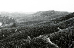 Regenerating forest allows the ridge-and-ravine topography to be clearly visible. |
| CLIMATE Rainfall, mean (mm) Temperature, mean (°C) Seasonal growth limitations | Annual 900 - 1600; lowest January (60 - 90), highest August or October (120 - 150) Annual 8 - 12, lowest July (3 - 7), highest February (16 - 20) Temperature <10°C (av.): May - September Rainfall < potential evapotranspiration: December - February; occasional winter snow |
| GEOLOGY Age, lithology | Cretaceous sandstones, mudstones, siltstones and conglomerates of the Strzelecki Group |
| PHYSIOGRAPHY Landscape Elevation range (m) Relative relief (m) Drainage pattern Drainage density (km/km2) | Steep hills with ridge-and-ravine topography 60 - 500 80 - 200 Dendritic 1.8 |
| PRESENT LAND USE | Mostly uncleared: hardwood forestry; bush grazing of cattle (limited) Minor proportion cleared: grazing of beef and dairy cattle on improved pastures; softwood plantations |
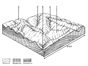 | 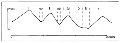 |
| LAND COMPONENT Percentage of land system Diagnostic features | 1 65 Steep slopes, with old landslide scars common, and narrow rounded crests | 2 15 Less steep lower slopes, often poorly drained | 3 10 Broader rounded ridge crests, mostly at lower elevations | 4 5 Steeper slopes of gullies and ravines | 5 5 Small flats within major drainage corridors |
| PHYSIOGRAPHY Slope %, typical and (range) Slope shape | 35 - 40, (30 - 60) Straight | 15 - 25, (5 - 30) Straight | 5 - 10, (0 - 15) Convex | Variable, (5 - 20) Straight | 2, (0 - 5) Straight |
| SOIL | |||||
| Parent material | Mudstone, siltstone and sandstone | ||||
| Description | Dark greyish brown loam medium clayto light clay merging into brown to yellowish brown | Mostly as for component1; some duplex profiles | No observations — shallow brown soil on steep slopes; humic wet soil in ravine bottoms | Locally derived alluvium Brown sandy loam to sandy clay loam, commonly clay at depth | |
| Classification | Brown Earths Uf6.11, Gn3.21, Gn4.71, Gn4.51 | Brown Earths, Grey-brown Podzolic Soils Uf6.13, Gn3.91, Gn4.31, Gn4.51, Dy3.21 | - - | Alluvial Soils Um5.52, Gn4.51 | |
| Surface texture | Loam to light clay | Loam to light clay | Loam to clay loam | Sandy loam to sandy clay loam | |
| Surface consistence | Hard | Hard | Variable | Slightly hard | |
| Depth (m) | 1.0 - 2.0 | 1.0 -2.0 | Variable | >2.0 | |
| Nutrient status | Moderate | Moderate | Moderate | Moderate | |
| Available soil water capacity | Moderate | Moderate | Moderate | Moderate | |
| Perviousness to water | Moderate to rapid | Moderate to rapid | Moderate to rapid | Moderate to rapid | |
| Drainage | Good | Moderately good to good | Variable | Variable | |
| Exposed stone (%) | 0 | 0 | 0 | 0 | |
| Sampled profile number | 14, 34 | - | - | - | |
| NATIVE VEGETATION Structure of vegetation and characteristic species of dominant stratum (+ Predominant species) | Protected aspects or where rainfall <1100 mm, layered open forest III: E. regnans+ More exposed aspects, or where rainfall >1100 mm, open forest II, III: E. obliqua+, E. globulus+, E. cypellocarpa | Layered open forest III with ferns: E. regnans+, Dicksonia antarctica, Alsophilaaustralis | Shrubby open forest III, IV: E. viminalis+ with or without E. regnans+ | ||
Disturbance | Affected process and trend | Primary resultant deterioration | Casual activities | Primary off-site process | ||
Form | Susceptibility of components | Incidence with components | ||||
— reduction in leaf area, rooting depth and/or perenniality — reduction in density of tree roots |
resulting in: a) increased deep percolation and leaching b) increased regolith wetness Decreased root-binding |
Nutrient loss Soil creep Soil creep |
Not determined 1,4; high 2; moderate 1,4; high 2; moderate |
Not determined Common: visible on cleared land Common: visible on cleared land |
Removal of trees Accelerated by clearing major disturbance of the native vegetation Accelerated by clearing major disturbance of the native vegetation |
Increased movement of water to groundwater; increased base-flow of streams Increased sediment load Increased sediment load |
|
|
|
3; moderate |
|
|
|
|
with Reduced infiltration |
Sheet and rill erosion |
5; moderate 1,2,4; high 3; moderate |
Common |
As for sheet and rill erosion above |
Increased flash flows |
|
|
Streambank erosion |
2,3; moderate 5; high |
Uncommon |
As for sheet and rill erosion above |
Increased sediment load and turbidity of streams |
| ||||||
© State of Victoria (Agriculture Victoria) 1996 - .

This work, Victorian Resources Online, is licensed under a Creative Commons Attribution 4.0 licence. You are free to re-use the work under that licence, on the condition that you credit the State of Victoria (Agriculture Victoria) as author, indicate if changes were made and comply with the other licence terms.
The licence does not apply to ‘branding’ or some ‘images or photographs’ that may be owned by third parties. We ask you to seek prior approval to use images using the VRO feedback form. Access to higher quality images can also be provided on request.
This page was last updated on .