
Freestone (Fr)
 | Area: 17 sq. km (0.1%) Towards the end of the period when the later Pleistocene terrace materials were being deposited, a small preliminary drop in base level, probably caused by a eustatic movement, seems to have occurred. Freestone land system is mapped on this lower planation surface. whereas remnants of the alluvial outwash fans, are mapped in the Briagalong land system. Materials are broadly similar to those of Briagolong land system but the soils are slightly younger and the alluvium often contains coarse, subangular gravels. Most of the surficial alluvial deposits are clays and silts. The dominant soils are relatively young. reddish and uniformly textured with alkaline subsoils. The reddish colours may be the result of good deep percolation or be inherited from the parent alluvium. In the poorly-drained, yellowish soils of low-lying areas, it is probable that little soil formation beyond organic matter accumulation and mottling has taken place. The native vegetation, probably grassy open forest II dominated by E. tereticornis, has been almost entirely cleared. | 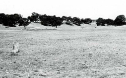 The flat terrain in the foreground is typical of Freestone land system; Redgum 2 land system is in the background at a higher elevation The flat terrain in the foreground is typical of Freestone land system; Redgum 2 land system is in the background at a higher elevation |
| CLIMATE Temperature, mean (°C) Seasonal growth limitations |
Annual 12 - 14; lowest July (8 - I0), highest February (19 - 21) Temperature <10°C (av.): June - August Rainfall < potential evapotranspiration: November – March |
| GEOLOGY Age, lithology |
Upper Pleistocene alluvial outwash terrace of gravels, sands, minor silts and clays |
| PHYSIOGRAPHY Landscape Elevation range (m) Relative relief (m) Drainage pattern Drainage density (km/km2) |
Alluvial plain 20 - 60 0 - 5 Undeveloped 0.3 |
| PRESENT LAND USE |
|
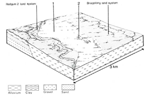 | 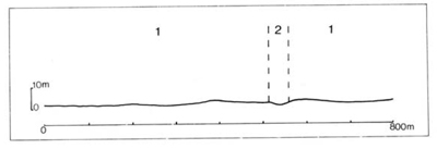 |
| LAND COMPONENT Percentage of land system Diagnostic features | 1 80 Gently undulating plains | 2 20 Channels. swales and depressed areas |
| PHYSIOGRAPHY Slope %, typical and (range) Slope shape | <5, (0 - 10) Straight or slightly convex | 1, (0 - 51 Concave |
| SOIL | ||
| Parent material | Alluvium, probably mainly medium- and fine-textured: some gravel | |
| Description | Limited observations — reddish with somewhat lighter coloured subsurface (A,) horizons: uniform, medium or fine textures. Gravelly subsoil may be typical | No observations — probably mainly mottled greyish brown fine textured: likely to he inundated at times by run-off |
| Classification | Red Earths Um5.52 | Wiesenboden probably - |
| Surface texture | Probably loam to clay loam | Probably clay loam to clay |
| Surface consistence | Slightly hard to hard when dry | Firm when moist |
| Depth (m) | >2.0 | >2.0 |
| Nutrient status | Moderate | Moderate |
| Available soil water capacity | Moderate | Moderate |
| Perviousness to water | Slow to moderate | Slow |
| Drainage | Moderately good to good | Very poor to poor |
| Exposed stone (%) | 0 | 0 |
| Sampled profile number | - | - |
| NATIVE VEGETATION Structure of vegetation and characteristic species of dominant stratum (+ Predominant species) | Probably mainly grassy open forest II of E. tereticornis Clearing has made it difficult to determine if any other predominant or associated tree species | |
Disturbance | Affected process and trend | Primary resultant deterioration | Casual activities | Primary off-site process | ||
Form | Susceptibility of components | Incidence with components | ||||
— reduction in leaf area, rooting depth and/or perenniality |
|
|
|
|
|
|
|
|
|
|
|
|
|
|
With reduced infiltration |
Sheet and rill erosion |
2; high 1; low |
Uncommon |
As for sheet and rill erosion above |
Increased ponding of water |
|
|
|
2: low. but high in channels |
minor channelled areas |
erosion above |
|
| ||||||
© State of Victoria (Agriculture Victoria) 1996 - .

This work, Victorian Resources Online, is licensed under a Creative Commons Attribution 4.0 licence. You are free to re-use the work under that licence, on the condition that you credit the State of Victoria (Agriculture Victoria) as author, indicate if changes were made and comply with the other licence terms.
The licence does not apply to ‘branding’ or some ‘images or photographs’ that may be owned by third parties. We ask you to seek prior approval to use images using the VRO feedback form. Access to higher quality images can also be provided on request.
This page was last updated on .