
Briagolong (Bg)
 | Area: 119 sq. km (0.6%) Prior-stream courses are clearly evident across parts of the later Pleistocene terrace; most of these are included in the Briagolong land system. Partially infilled stream channels occur together with characteristic old levees of reddish alluvium. This reddish alluvium is extensive in the upstream parts of the former stream courses. Near Cowwarr and Briagolong. the old stream deposits resemble outwash fans. Further downstream a clay plain becomes more common and ultimately dominates, to become the Sale land system. Local run-off water still ponds in some of the old stream channels. Most of the surface alluvial deposits are clays and silts. The frequency of reddish colours in these materials is probably due to high permeability and to redness of the parent materials. In most of the land system, duplex and gradational soils have formed. Leaching has not been very intense and the subsoils tend to be neutral to slightly alkaline at depth, possibly due to the presence of calcium carbonate or sodium ions. Where drainage is poorer the soils are often strongly mottled. The native vegetation. now almost entirely removed. appears to have been mainly grassy open forest II dominated by E. tereticornis. | 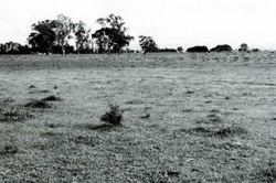 A Briagolong relict channel with Eucalyptus tereticornis (forest red gum) growing on the Hatter land above it. |
| CLIMATE Rainfall, mean (mm) Temperature, mean (°C) Seasonal growth limitations |
Annual 500 - 800: lowest July (30 - 50), highest October (50 - 80) Annual 12 - 14: lowest July (8 - 10). highest February (19 - 21) Temperature <10°C (av.): June - August Rainfall < potential evapotranspiration: November – March |
| GEOLOGY Age, lithology |
Upper Pleistocene alluvial deposits of gravels, sands, minor silts and clays |
| PHYSIOGRAPHY Landscape Elevation range (m) Relative relief (m) Drainage pattern Drainage density (km/km2) |
Relict levees and outwash fans 20 - 60 0 - 10 Dendritic 1.4 |
| PRESENT LAND USE |
|
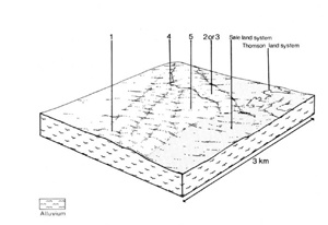 | 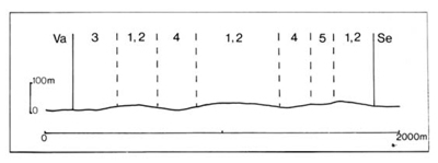 |
| LAND COMPONENT Percentage of land system Diagnostic features | 1 30 Dissected fans with red soils | 2 20 Levees and levee slopes with loamy to clayey soils | 3 20 Levees and levee slopes with sandy soils | 4 15 Plains (too small to map as Sale land system) | 5 15 Channels, swales, oxbows, often partially filled |
| PHYSIOGRAPHY Slope %, typical and (range) Slope shape | <5. (0 - 15) Convex | 2. (0 - 5) Convex, concave | 2. (0 - 5) Convex, concave | 2, (0 - 3) Straight | 1, (0 - 5) Concave |
| SOIL | |||||
| Parent material | Silt, clay, sand and gravel | ||||
| Description | Dark brown sandy loam to clay loam topsoil abruptly overlying blocky red or reddish brown clay subsoil | Limited observations — probably as for component 1, but often with lighter textured subsoil | No observations — probably uniform and gradational soils with sandy textures | Limited observations — mottled yellow and brown gradational, duplex and uniform soils | No observations — probably mottled greyish brown fine textured soils |
| Classification | Red-brown Earths and intergrades with Solodic Soils Dr2.22. Dr3.21. Dr3.22 | Red-brown Earths, Red Earths Dr3.22. Um5.52 | - | Wiesenboden, Yellow Earths. Yellow Podzolic Soils and Solodic Soils Gn3.73. Um5.52 | Humic Gleys |
| Surface texture | Sandy loam to clay loam | - | Probably clay loam to clay | ||
| Surface consistence | Soft to hard when dry | - | Firm when moist | ||
| Depth (m) | >2.0 | >2.0 | Probably similar to Sale land system, component 1 | >2.0 | |
| Nutrient status | Moderate | Low to moderate (?) | Moderate | ||
| Available soil water capacity | Moderate | Low to moderate (?) | Moderate | ||
| Perviousness to water | Slow | Slow to moderate | Moderate to rapid | Slow | |
| Drainage | Moderately good to good | Moderately good to good | Good | Very poor to poor | |
| Exposed stone (%) | 0 | 0 | 0 | 0 | 0 |
| Sampled profile number | 57.58 | - | - | - | - |
| NATIVE VEGETATION Structure of vegetation and characteristic species of dominant stratum (+ Predominant species) | Grassy open forest II: E. tereticornis+ Clearing has made it difficult to determine if any other predominant or associated species | ||||
Disturbance | Affected process and trend | Primary resultant deterioration | Casual activities | Primary off-site process | ||
Form | Susceptibility of components | Incidence with components | ||||
— reduction in leaf area, rooting depth and/or perenniality | Reduced transpiration, resulting in increased deep percolation and leaching | Nutrient loss | Not determined | Not determined | Removal of trees | Increased movement of water to groundwater. |
| Increased overland flow and soil detachment | Sheet and rill erosion | 1; low 2,3; moderate | Uncommon; local occurrence | Clearing, cultivation, burning, overgrazing, earth-moving activities, rabbit burrowing, trafficking by stock and vehicles. | Increased flash flows and sediment load. |
| Increased compaction With reduced infiltration | Structure decline Sheet and rill erosion | 1,2,4; moderate 3; low – moderate l: low 2.3: moderate | Not determined Uncommon: local occurrence | Increased trafficking and cultivation, overgrazing, export of organic matter As for sheet and rill erosion above | - Increased flash flows |
| Increased soil break-up | Gully erosion | 12,3,4: low 5; moderate | Uncommon; local occurrence | As for sheet and rill erosion above | Increased sediment load. |
| Comments: - | ||||||
© State of Victoria (Agriculture Victoria) 1996 - .

This work, Victorian Resources Online, is licensed under a Creative Commons Attribution 4.0 licence. You are free to re-use the work under that licence, on the condition that you credit the State of Victoria (Agriculture Victoria) as author, indicate if changes were made and comply with the other licence terms.
The licence does not apply to ‘branding’ or some ‘images or photographs’ that may be owned by third parties. We ask you to seek prior approval to use images using the VRO feedback form. Access to higher quality images can also be provided on request.
This page was last updated on .