
Barrier (Br)
 | Area: 78 sq. km (0.5%) Dunes, sandy rises and sand sheets occur in inland positions. Some of these are old coastal dune and harrier systems were stranded following tectonic uplift, while others were built by inland aeolian activity. The scattered remnants of the old harriers and dunes are now much modified by dissection and deflation and, although obvious on aerial photos, are not always prominent in the field. Sometimes the steep, seaward dune faces have been retained, with wind deformation concentrated on the landward side, producing parabolic dunes. In the Seaspray-Dutson area, extended linear forms persist. The largest harrier and dune forms are mapped in this Barrier land system. The associated low dunes, sand sheets and rises are in Perry land system. The soils are mostly acidic, infertile, and droughty sands, dark at the top and bleached in the subsurface. Iron and/ or humus-enriched, soil horizons, either hardpans or soft layers, occur at depth. The soils are susceptible to wind erosion. The vegetation is mainly ferny woodland or ferny open woodland I and II, with heathy open woodland I on the deeper sands of upper slopes. Sedgeland occurs in swales with open forest I on the margin. | 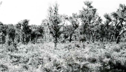 Banksia serrata (saw banksia) and bracken growing on low sand ridges |
| CLIMATE Rainfall, mean (mm) Temperature, mean (°C) Seasonal growth limitations | Annual 500 - 800; lowest January (30 - 50), highest October (40 - 70) Annual 12 - 14: lowest July (9 - 10). highest February (19 - 20) Temperature <10°C (av.): June - August Rainfall < potential evapotranspiration: November - March |
| GEOLOGY Age, lithology | Pleistocene aeolian and coastal sand deposits |
| PHYSIOGRAPHY Landscape Elevation range (m) Relative relief (m) Drainage pattern Drainage density (km/km2) | Large linear and deformed parabolic dunes. sometimes originating from stranded coastal harriers 0 – 120 0 - 20 Nil 0 |
| PRESENT LAND USE | Mostly uncleared: hardwood forestry (minor timber products); bush grazing of cattle (limited); apiculture (limited); small area in Moormurng Forest Park |
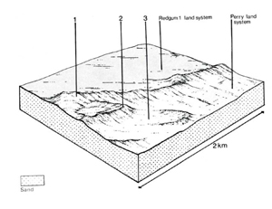 | 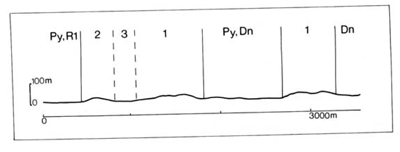 |
Percentage of land system Diagnostic features | 1 75 Barrier beach-ridges | 2 15 Parabolic dunes | 3 10 Swales |
Slope %, typical and (range) Slope shape | 5, (0 - 20) Concave and convex | 5, (0 - 15) Concave and convex | <1, (0 - 2) Straight and concave |
| |||
| Wind-sorted sand | Wind-sorted sand; possibly lacustrine silt and clay | |
| Dark sand over pale or whitish sand over coffee rock or uncemented bright yellowish brown sand; yellow sand at depth | No observations | |
| Podzols, Siliceous Uc2.32, Uc2.36, Uc4.21, Uc4.22, Uc4.32, Uc4.33 | Probably Gleyed Podzolic Soils; Humic Gleys - | |
| Sand | Sand | |
| Loose or soft | Loose or soft | |
| >2.0 | >2.0 | |
| Very low | Very low | |
| Very low | Very low | |
| Very low | Very rapid | |
| Somewhat excessive | Very poor to somewhat poor | |
| 0 | 0 | |
| 71 | - | - |
Structure of vegetation and characteristic species of dominant stratum (+ Predominant species) | Mainly ferny or open woodland I, II: E. globoidea+ (usually clay at depth) or E. viminalis var. racemosa+, Pteridium esculentum and sometimes Banksia serrata Heathy open woodland I: E. nitida+, B. serrata | Mainly sedgeland with Lepyrodia muelleri+, Lepidosperma longitudinale. Schoenus brevifolius Occasionally open heath of Leptospermum juniperinum Margins with open forest I of E. ovata+ and/or E. cephalocarpa+ | |
Disturbance | Affected process and trend | Primary resultant deterioration | Casual activities | Primary off-site process | ||
Form | Susceptibility of components | Incidence with components | ||||
— reduction in leaf area, rooting depth and/or perenniality |
resulting in increased deep percolation and leaching |
| 1,2; high 3; low |
| Removal of trees |
|
|
over soil and increased detachment of sand |
| 12; high |
topographically exposed sites | Trafficking. overgrazing, rabbit burrowing, cultivating, earthmoving activities. |
|
|
|
| 1.2; very low 3: low - moderate |
| Increased trafficking and cultivation. overgrazing, export of organic matter |
|
|
sand |
| 1.2; high |
| Trafficking, overgrazing, rabbit burrowing. cultivating, earthmoving activities. |
|
| Comments: Regeneration of vegetative cover is usually slow because of droughty soils with low fertility. | ||||||
© State of Victoria (Agriculture Victoria) 1996 - .

This work, Victorian Resources Online, is licensed under a Creative Commons Attribution 4.0 licence. You are free to re-use the work under that licence, on the condition that you credit the State of Victoria (Agriculture Victoria) as author, indicate if changes were made and comply with the other licence terms.
The licence does not apply to ‘branding’ or some ‘images or photographs’ that may be owned by third parties. We ask you to seek prior approval to use images using the VRO feedback form. Access to higher quality images can also be provided on request.
This page was last updated on .