
Perry (Py)
 | Area: 395 sq. km (1.9%) Sand sheets and low dunes on the Tertiary and early Pleistocene terraces have been mapped in Perry land system. Much of the sand was deposited by streams such as the Perry River, and subsequently blown eastwards from the flood plains during a dry glacial period. In areas to the south of Lake Wellington, which have suffered a marine inundation, longshore and beach drift appear to have moved the sand eastwards, shaping it into coastal and sea-floor forms. Sandy soils are prevalent but they are underlain by clays at variable depths. Deep sands tend to he highly acidic, infertile and droughty, with dark topsoils, bleached subsurfaces and with iron and/or humus-enriched pans at depth. Where the underlying clay is shallow, drainage may be restricted. This clay commonly exhibits sodic properties. The vegetation is mainly open woodland I and II, sometimes ferny or heathy, with open forest II on duplex soils and sedgelands in wet areas. | 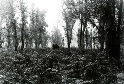 Woodland of Eucalyptus nitida (shining peppermint) and Banksia serrata (saw banksia) growing on a relict beach ridge |
| CLIMATE Rainfall, mean (mm) Temperature, mean (°C) Seasonal growth limitations | Annual 500 - 800: lowest January (30 - 50). highest October (40 - 70) Annual 12 - 14: lowest July (9 - 10). highest February (19 - 20) Temperature <10°C (av.): June - August Rainfall < potential evapotranspiration: November – March |
| GEOLOGY Age, lithology | Pleistocene aeolian and marine sands |
| PHYSIOGRAPHY Landscape Elevation range (m) Relative relief (m) Drainage pattern Drainage density (km/km2) | Sand sheets and low dunes <2.0 - 120 0 - 10 Dendritic 0.1 |
| PRESENT LAND USE | Mostly uncleared: hardwood forestry (minor timber products); apiculture: bush grazing of cattle (limited); small area in Moormurng Forest Park Minor proportion cleared: grazing of cattle and sheep; softwood plantations |
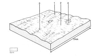 | 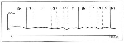 |
| LAND COMPONENT Percentage of land system Diagnostic features | 1 55 Low sand ridges formed by modification of sand sheets | 2 25 Thin sand sheets over clay sub strata | 3 10 Seasonally waterlogged swales and margins to lagoons | 4 10 Permanent lagoons |
| PHYSIOGRAPHY Slope %, typical and (range) Slope shape | 3, (0 - 5) Convex and concave | 2, (0 - 5) Straight | <1, (0 - 2) Straight or concave | 0, (-) Concave |
| SOIL | ||||
| Parent material | Aeolian sand | Aeolian sand; marine — lacustrine clay | Aeolian sand; marine — lacustrine clay | - |
| Description | Dark sand over whitish sand overlying coffee rock or bright yellowish brown sand; yellow sand below | Dark sand over paler sand overlying mottled, often alkaline clay | Limited observations — black sand over light grey sand often overlying mottled clay | No soils |
| Classification | Podzols Uc2.21, Uc2.36, Uc4.31, Uc4.32 | Solodic Soils Dy3.23, Dy5.23 | Gleyed Podzolic Soils, Humic Gleys Dd4.41, Uc1.41 | - |
| Surface texture | Sand | - | ||
| Surface consistence | Loose or soft | - | ||
| Depth (m) | >2.0 | - | ||
| Nutrient status | Very low | - | ||
| Available soil water capacity | Very low | - | ||
| Perviousness to water | Very rapid | Slow | Slow | - |
| Drainage | Somewhat excessive | Somewhat poor | Poor | - |
| Exposed stone (%) | 0 | 0 | 0 | - |
| Sampled profile number | 73 | - | - | - |
| NATIVE VEGETATION Structure of vegetation and characteristic species of dominant stratum (+ Predominant species) | Mainly ferny woodland or open woodland I, II: E. globoidea (in higher rainfall areas) or E. viminalis var. racemosa with Pteridium esculentum; Banksia serrata sometimes associated Heathy open woodland I on deeper sands of upper slopes: E. nitida+, B. serrata | Grassy or shrubby open forest II: With decreasing depth to clay — E. globoidea+, E. tereticornis+, E. bridgesiana+, E. ovata+; E. polyanthemos may be associated | Mainly sedgeland: Lepyrodia muelleri+, Lepidosperma longitudinale, Schoenus brevifolius Occasionally open heath: Leptospermum juniperinum Open forest I: E. ovata+ and/or E. cephalocarpa+ | No vegetation |
|
|
|
|
| ||
|
|
| ||||
— reduction in leaf area, rooting depth and/or perenniality |
|
|
2; low |
|
|
|
|
|
|
2; low |
|
|
|
|
|
|
3; low - moderate |
|
|
|
|
|
|
2; low |
|
|
|
| ||||||
© State of Victoria (Agriculture Victoria) 1996 - .

This work, Victorian Resources Online, is licensed under a Creative Commons Attribution 4.0 licence. You are free to re-use the work under that licence, on the condition that you credit the State of Victoria (Agriculture Victoria) as author, indicate if changes were made and comply with the other licence terms.
The licence does not apply to ‘branding’ or some ‘images or photographs’ that may be owned by third parties. We ask you to seek prior approval to use images using the VRO feedback form. Access to higher quality images can also be provided on request.
This page was last updated on .