
Bindi (Bi)
 | Area: 27 sq. km (0.1%) This land system is confined to an area of Devonian calcareous marine sediments interbedded with siltstones, at low elevations in the north-east of the survey area. Broad alluvial floors (the broadest of which are mapped in Walnut land system) and colluvial fill on lower slopes are characteristic. Topography ranges from low hills to undulating terrain, with rock outcrop on some strike ridges. Secondary, calcareous accumulations occur on some breaks-of-slope. Shallow, reddish brown clays with fine structure have developed under low to moderate rainfall on the calcareous and silty, siliceous parent rocks. Lime is often present in the soil close to the surface and the reaction is usually neutral in the topsoil and alkaline at depth. The shallowness of the soil leads to low water-holding capacity and periodic water stress. Now almost entirely cleared, the original vegetation was probably mainly a grassy woodland II, with open forest II on lower colluvial slopes and alluvial terraces. | 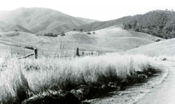 Cleared low hills and undulating terrain adjacent to the forested slopes of Blomford land system Cleared low hills and undulating terrain adjacent to the forested slopes of Blomford land system |
| CLIMATE Rainfall, mean (mm) Temperature, mean (°C) Seasonal growth limitations |
Annual 500 - 800; lowest July (30 - 50), highest October (50 - 80) Annual 12 - 14; lowest July (8 - 10), highest February (19 - 21) Temperature <10°C (av.): May - September Rainfall < potential evapotranspiration: November – March |
| GEOLOGY Age, lithology |
Devonian; Taravale Formation, Buchan Group; siltstones with interbedded limestones, sometimes nodular |
| PHYSIOGRAPHY Landscape Elevation range (m) Relative relief (m) Drainage pattern Drainage density (km/km2) |
Low hills and undulating terrain 400 - 700 80 - 120 Dendritic 1.3 |
| Mostly cleared: mainly grazing by beef cattle and sheep, mostly on improved pastures |
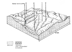 | 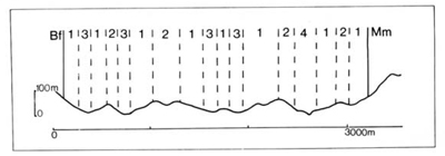 |
| LAND COMPONENT Percentage of land system Diagnostic features | 1 55 Long gentle slopes | 2 20 Short steeper slopes normal to strike with outcrop of calcareous rock | 3 15 Lower slopes and some fans with deep soils | 4 10 Valley flats |
| PHYSIOGRAPHY Slope %, typical and (range) Slope shape | 10 - 20, (5 - 30) Concave, some convex | 20 – 30, (10 - 40) Straight | 5, (2 - 15) Concave | <2, (0 - 5) Straight but uneven |
| SOIL | ||||
| Parent material | Siltstone and interbedded limestone | Colluvium and local alluvium | Alluvium | |
| Description | Shallow reddish brown granular or fine blocky structured clay, often stony | Alternating rock outcrop and very shallow soil, otherwise similar to component 1 | Variable; deep reddish brown fine blocky clay: dark grey mottled clay where drainage poor | Limited observations — black sandy clay loam to clay loam over stratified alluvium of variable texture |
| Classification | Euchrozems Gn3.13 | Euchrozems Um6.24 | Terra Rossas. Solodic Soils Gn3.15. Dy3.23 | Alluvial Soils Um6.22 |
| Surface texture | Clay loam | Clay loam | Loam to clay loam | Medium textures |
| Surface consistence | Very hard when dry | Very hard when dry | Hard to very hard when dry | Very hard when dry |
| Depth (m) | Mostly 0.4 - 0.8 | <0.4, some deeper pockets | >2.0 | >2.0 |
| Nutrient status | Moderate | Moderate | Moderate | Moderate to high |
| Available soil water capacity | Moderate | Moderate | Moderate | Moderate |
| Perviousness to water | Slow | Slow | Slow | Slow to moderate |
| Drainage | Good | Good | Variable: somewhat poor to good | Good |
| Exposed stone (%) | Generally 0 | Generally 0 | 0 | 0 |
| Sampled profile number | - | - | 33 | - |
| NATIVE VEGETATION Structure of vegetation and characteristic species of dominant stratum (+ Predominant species) | Grassy woodland II: E. pauciflora+. E. viminalis | Grassy woodland II: E. pauciflora+ | Open forest II: E. goniocalyx+. E. polyanthemos | Limited data — probably open forest II with E. viminalis |
Disturbance | Affected process and trend | Primary resultant deterioration | Casual activities | Primary off-site process | ||
Form | Susceptibility of components | Incidence with components | ||||
— reduction in leaf area, rooting depth and/or perenniality |
| Nutrient loss | Not determined | Not determined |
|
|
|
| Sheet and rill erosion | 1,2,3; moderate - high | Common |
|
|
|
With reduced infiltration | Structure decline Sheet and rill erosion | 12.3.4; moderate 12,3.4; moderate - high | Common on the gentler slopes Common |
As for sheet and rill erosion above |
Increased flash flows |
|
| Gully erosion | I; moderate 2; low 3,4; high | Common |
|
|
| Comments: Vegetative cover regenerates only slowly, particularly on exposed aspects because of hot, dry summers and autumns. | ||||||
© State of Victoria (Agriculture Victoria) 1996 - .

This work, Victorian Resources Online, is licensed under a Creative Commons Attribution 4.0 licence. You are free to re-use the work under that licence, on the condition that you credit the State of Victoria (Agriculture Victoria) as author, indicate if changes were made and comply with the other licence terms.
The licence does not apply to ‘branding’ or some ‘images or photographs’ that may be owned by third parties. We ask you to seek prior approval to use images using the VRO feedback form. Access to higher quality images can also be provided on request.
This page was last updated on .