
Banksia (Ba)
 | Area: 26 sq. km (0.1%) The Banksia land system consists of parabolic dunes and intervening swales along the edges of Seacomhe land system. These dunes have been deflated to varying degrees, with initial aeolian excavation limited in places by the exposure of water tables. In these areas the dunes tend to be low because of the limited sand supply and subsequent erosion. Where the sand sheets are thicker, water tables were not exposed and the dunes are larger. All these dunes and swales, now stabilised by vegetation, are in Banksia land system. The sandy soils are acidic, infertile and droughty with dark upper horizons, bleached subsurfaces and with iron and/or humus-enriched pans at depth. The soils are susceptible to wind erosion. The vegetation is mainly heathy or ferny open woodland I. Where water tables are exposed, swamps carry an outer fringe of closed scrub, successively replaced towards the centre by rushland and herbfield, whilst the deepest parts are hare. | 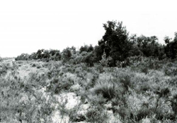 Heathy open woodland with Banksia serrata (saw banksia) growing on a low dune near Loch Sport Heathy open woodland with Banksia serrata (saw banksia) growing on a low dune near Loch Sport |
| CLIMATE Rainfall, mean (mm) Temperature, mean (°C) Seasonal growth limitations | Annual 500-800; lowest January (30-50), highest October (40-70) Annual 12-14; lowest July (9-10), highest February (19-20) Temperature <10oC (av.): No months Rainfall < potential evapotranspiration: November-March |
| GEOLOGY Age, lithology | Pleistocene stranded barrier sand deposits |
| PHYSIOGRAPHY Landscape Elevation range (m) Relative relief (m) Drainage pattern Drainage density (km/km2) | Parabolic dunes and swales 0-20 0-20 Nil 0 |
| PRESENT LAND USE | Mostly uncleared: Mostly within the Lakes National Park and Gippsland Lakes Coastal Park: apiculture Minor proportion cleared: holiday residential |
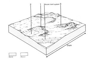 | 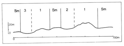 |
Percentage of land system Diagnostic features | 1 65 Dunes | 2 20 Dry wind-excavated swales | 3 15 Swampy wind-excavated swales with concentric vegetation zones |
Slope %, typical and (range) Slope shape | Variable, (0-30) Convex, some concave | <1, (0-5) Concave | <1, (0-5) Concave |
Parent materials | Wind-sorted sands | Wind-sorted sands | |
| Dark sand over pale or whitish sand over coffee rock or uncemented bright yellowish brown sand; yellow sand at depth. | No observations – probably black acidic sand over grey sand, possibly with coffee rock at depth where water table is deeper. | |
| Podzols Uc4.32, Uc4.22 | Humic Gleys, possibly some Podzols - | |
| Sand | Sand | |
| Loose or soft | Soft | |
| >2.0 | >2.0 | |
| Very low | Very low | |
| Very low | Very low | |
| Very rapid | Very rapid | |
| Somewhat excessive | Very poor to poor | |
| 0 | 0 | |
| - | Nichoslon (1978) Profile 756 | - |
Structure of vegetation and characteristic species of dominant stratum (+ Predominant species) | Inland dunes: heathy open woodland I of E. nitida, Banksia serrata (either predominant): Leptospermum myrsinoides or Thryptomene micrantha dominate the heath. Swales and dunes near the lakes: ferny open woodland I of E. viminalis var. racemosa, B. serrata or B. integrifolia (close to lakes) and Pteridium esculentum | From margins inwards: Closed scrub of Melaleuca ericifolia. Rushland of Juncua maritimus. Herbfield of Salicornia spp. Centre often free with water. | |
|
|
|
|
| ||
|
|
| ||||
- reduction in leaf area, rooting depth and/or perenniality | Reduced transpiration, resulting in increased deep percolation and leaching. | Nutrient loss | 1,2; high 3; low | Not determined | Removal of trees | Increased movement of water to groundwater, increased base-flow of streams |
| Increased wind velocity over soil and increased detachment of sand | Wind erosion | 1,2; high-very high | Uncommon | Trafficking, overgrazing, rabbit burrowing, cultivating, earthmoving activities. | Encroachment by sand. |
| Increased compaction | Structure decline | 1,2; very low 3; low-moderate | Uncommon | Increased trafficking and cultivation, overgrazing, export of organic matter | - |
| Increased loosening of sand | Wind erosion | 1,2; high-very high | Uncommon, but locally severe | Trafficking, overgrazing, rabbit burrowing, cultivating, earthmoving activities, particularly road building. | Encroachment by sand |
| Increased soil break-up | Wave erosion | 3; moderate | Uncommon but locally severe on exposed lake shores | Increased salinity of water had reduced protective role of Phragmites communis | Increased turbidity of water. | |
| Comments: Regeneration of vegetative cover is poor in areas exposed to wind and wave action; expensive remedial works may be required. | ||||||
© State of Victoria (Agriculture Victoria) 1996 - .

This work, Victorian Resources Online, is licensed under a Creative Commons Attribution 4.0 licence. You are free to re-use the work under that licence, on the condition that you credit the State of Victoria (Agriculture Victoria) as author, indicate if changes were made and comply with the other licence terms.
The licence does not apply to ‘branding’ or some ‘images or photographs’ that may be owned by third parties. We ask you to seek prior approval to use images using the VRO feedback form. Access to higher quality images can also be provided on request.
This page was last updated on .