
Seacombe (Sm)
 | Area: 85 sq. km (0.4%) Seacombe land system occurs on parts of the prior and inner barriers. Where the inner barrier is still intact there is an undulating sand sheet, produced by a series of broad but closely spaced beach ridges parallel to the coastline. The formation is of Pleistocene age, but more recent aeolian disturbance producing an incipient dune-like surface has occurred in areas like Sperm Whale Head. More severe, peripheral, aeolian attack of these beach ridges has created larger, mostly parabolic dunes; these dunes are mapped in Banksia land system. In other areas, the inner and prior barriers suffered partial dissection during the last major sea level fall and have since undergone lacustrine re-working to produce beach ridges of lower relief. The orientation of the beach ridges varies with the orientation of the paleo-lacustrine shores, rather than being parallel to the coastline. Often the beach ridges are no longer distinct and a sand sheet with an uneven surface occurs. Where there has been significant aeolian disruption of these lower ridges, the water table has been excavated and dunes with swampy cores occur. | 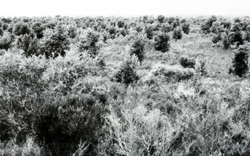 Very low sand ridges form a large uneven sand plain typical of Seacombe land system |
The sands may originally have contained shell fragments and carbonates, but now the soils are leached, infertile and strongly acidic, particularly in the topsoil. They also generally appear to have developed iron-indurated pans (coffee-rock) mostly at greater depths (deeper than 1.5 m) than in similar soils elsewhere in the region. Being of sandy texture throughout, the soils are droughty and susceptible to wind erosion. There is a moderate salinity hazard because of a saline, ground-water table close to the surface of the swales and low-lying areas. The vegetation is mainly a heathy open woodland of E. nitida and Banksia serrata. It is replaced by an open woodland of E. viminalis var. racemosa and B. serrata with Pteridium esculentum on lower moister site | ||
| CLIMATE Rainfall, mean (mm) Temperature, mean (°C) Seasonal growth limitations |
Annual 500 - 800; lowest January (30 - 50), highest October (40 - 70) Annual 12 - 14; lowest July (9 - 10), highest February (19 - 20) Temperature <10°C (av.): No months Rainfall < potential evapotranspiration: November – March |
| GEOLOGY Age, lithology |
Pleistocene sandy coastal barrier deposits |
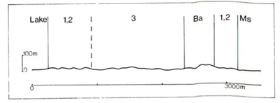
| PHYSIOGRAPHY Landscape Elevation range (m) Relative relief (m) Drainage pattern Drainage density (km/km2) |
Marine and lacustrine sand sheets formed from a series of relict beach ridges 0 - 20 0 - 5 Nil 0 |
| PRESENT LAND USE |
limited) Minor cleared areas: grazing of sheep and cattle |
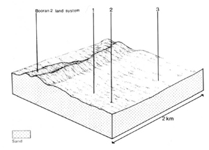 |  |
| LAND COMPONENT Percentage of land system Diagnostic features | 1 40 Closely spaced beach ridges forming gently undulating surface | 2 8 Swales | 3 52 Sand sheets of low and uneven relief. Occasional swamps in low-lying areas |
| PHYSIOGRAPHY Slope %, typical and (range) Slope shape | Variable, (0 - 20) Convex and concave | <1, (0 - 2) concave | 1- 2, (0 - 5) Straight but uneven |
| SOIL | |||
| Parent material | Marine and lacustrine sand, locally redistributed by wind | ||
| Description | Limited observations — leached acidic sand, black or dark grey at the surface, pale brown or whitish in the subsurface often over contrasting dark yellowish brown sand or coffee rock; light yellowish coloured sandy subsoil. Depth to coffee rock or the dark yellowish brown sand variable, probably between 1 and 2 m | ||
| Classification | Podzols, Siliceous Sands Uc4.31, Uc2.32, probably also Uc4.2-, Uc2.2- and Uc1.21 | ||
| Surface texture | Sand | ||
| Surface consistence | Loose or soft when dry | ||
| Depth (m) | >2.0 | ||
| Nutrient status | Very low | ||
| Available soil water capacity | Very low | ||
| Perviousness to water | Very rapid | ||
| Drainage | Somewhat excessive | ||
| Exposed stone (%) | 0 | ||
| Sampled profile number | Nicholson (1978), profile 755 | - | |
| NATIVE VEGETATION Structure of vegetation and characteristic species of dominant stratum (+ Predominant species) | Mainly heathy open woodland I: E. nitida, Banksia serrata (either predominant) Understorey dominated mostly by Leptospermum myrsinoides or Thryptomene micrantha On moister sites, ferny open woodland I: E. viminalis var. racemosa+, B. serrata, Pteridium esculentum | Mainly open woodland I: E. viminalis var. racemosa+ with Pteridium esculentum Swamps with Gahnia spp. or Juncus maritimus and/or Lepidosperma longitudinale and usually with fringe of Melaleuca ericifolia or M. squarrosa | |
|
|
|
|
| ||
|
|
| ||||
— reduction in leaf area, rooting depth and/or perenniality |
resulting in: a) increased deep percolation and leaching b) raised groundwater table |
Nutrient loss Salting |
1,2,3; high 2,3; low |
Not determined Uncommon: isolated occurrences |
Removal of trees Reduced plant water use in the catchment |
Increased movement of water to groundwater Raised groundwater table |
|
|
Wind erosion |
1,2,3; high |
Uncommon: but locally severe |
|
Encroachment by sand |
|
|
|
2,3; low |
|
|
|
|
|
Wave erosion |
2,3; moderate |
Uncommon |
As for wave erosion above |
Increased turbidity of water |
| ||||||
© State of Victoria (Agriculture Victoria) 1996 - .

This work, Victorian Resources Online, is licensed under a Creative Commons Attribution 4.0 licence. You are free to re-use the work under that licence, on the condition that you credit the State of Victoria (Agriculture Victoria) as author, indicate if changes were made and comply with the other licence terms.
The licence does not apply to ‘branding’ or some ‘images or photographs’ that may be owned by third parties. We ask you to seek prior approval to use images using the VRO feedback form. Access to higher quality images can also be provided on request.
This page was last updated on .