
Soil/Landform Unit 56
Landform Unit Description
Page top
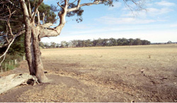
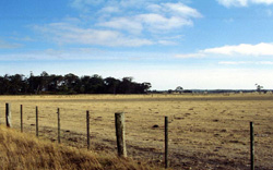 Level plain of the swamp north of Lal Lal. The vegetation stand in this photo represents a sandy ridge that surrounds the western fringe of the swamp |
0.03% of CMA region This vast swamp located near Lal Lal comprises Quaternary clay and sands in the north-east of the Corangamite catchment. Here much of the land has been cleared with very little remnant vegetation. The vegetation class is Aquatic Herbland/Plains Sedgy Wetland Mosaic with the dominant species Eucalyptus ovata. The sedimentary sands and clay have a low inherent fertility and low water holding capacity. Land use is mainly restricted to grazing owing to the waterlogged state of soil in most years. Soils include acidic mottled texture contrast soils with areas of alkaline grey cracking clays. While waterlogging is a major limitation, soil compaction is also a limitation for production of crops with shallow topsoils. |  |
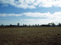 Land use on the plains is limited to grazing |  |
|  Eucalyptus ovata is the main remainin Eucalyptus species of the swamp |
Component | 1 |
Proportion of soil-landform unit | 100% |
| CLIMATE Rainfall (mm) | Annual: 760 |
| Temperature (oC) | Minimum 7, Maximum 17 |
| Precipitation less than potential evapotranspiration | November-March |
| GEOLOGY Age and lithology | Quaternary clay and sand, minor Neogene sand |
| Geomorphology | |
| LANDUSE | Uncleared: Nature conservatin, water supply Cleared: Grazing, occasional cropping (cereal) |
| TOPOGRAPHY Landscape | Swamp |
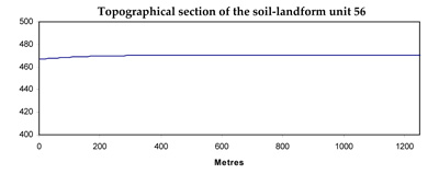
| Elevation range (m) | 420-475 |
| Local relief (m) | 1 |
| Drainage pattern | Dendritic |
| Drainage density (km/km2) | 1.3 |
| Landform | Swamps and depressions |
| Landform element | |
| Slope and range (%) | 1 |
| Slope shape | Flat |
| NATIVE VEGETATION Ecological Vegetation Class | Aquatic Herbland/Plains Sedgy Wetland Mosaic (7.8%) |
| Dominant species | E. ovata |
| SOIL Parent material | Unconsolidated sands, silts and clays |
| Description (Corangamite Soil Group) | |
| Soil type sites | |
| Surface texture | Light clay/clay |
| Permeability | Low |
| Depth (m) | 2 |
| LAND CHARACTERISTICS, POTENTIAL AND LIMITATIONS | Slowly permeable soils and hardsetting surfaces result in significant waterlogging. Soil compaction is also a limitation for soils with shallow topsoils. |
© State of Victoria (Agriculture Victoria) 1996 - .

This work, Victorian Resources Online, is licensed under a Creative Commons Attribution 4.0 licence. You are free to re-use the work under that licence, on the condition that you credit the State of Victoria (Agriculture Victoria) as author, indicate if changes were made and comply with the other licence terms.
The licence does not apply to ‘branding’ or some ‘images or photographs’ that may be owned by third parties. We ask you to seek prior approval to use images using the VRO feedback form. Access to higher quality images can also be provided on request.
This page was last updated on .