
Soil/Landform Unit 54
Landform Unit Description
Page top
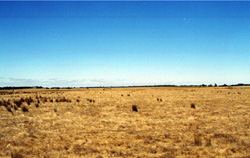 Near level plains south of Elaine. The occurrence of spiny rush on these plains indicates that drainage is relatively low |
0.07% of CMA region The gently undulating plains in the Myrniong and Morrisons area are derived from Quaternary volcanics. Vegetation classes include Plains Grassy Woodland, Basalt Escarpment Shrubland and Grassy Dry Forest. The weathered basalt has moderate inherent fertility levels and a moderate water holding capacity. Soils include acidic and neutral mottled black texture contrast soils. There are minor occurrences of acidic mottled brown, grey or yellow and mottled brown texture contrast soils, and neutral shallow grey clays with a few surface stones. There are areas of extensive gilgai microrelief where the soils are acidic mottled black or neutral mottled brown, grey or yellow texture contrast soils. Sheet and rill erosion is associated with major rainfall events while gully erosion and leaching of salts also occur lower in the topography. | 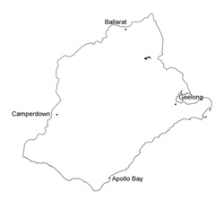 |
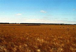 The main land use of these plains is grazing for fat lamb production | 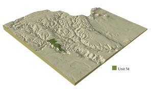 |
| 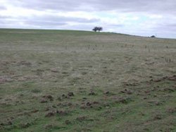 Minor ripping has been undertaken in this paddock for deep drainage |
Component | 1 | 2 | 3 | 4 |
Proportion of soil-landform unit | 63% | 2% | 1% | 34% |
| CLIMATE Rainfall (mm) | Annual: 670 | |||
| Temperature (oC) | Minimum 8, Maximum 18 | |||
| Precipitation less than potential evapotranspiration | October-March | |||
| GEOLOGY Age and lithology | Quaternary basalt, Neogene fluvio-marine sand, minor clay, sand and gravel, minor Ordovician marine sandstone and shale | |||
| Geomorphology | ||||
| LANDUSE | Uncleared: Nature conservation, water supply Cleared: Seep and beef cattle grazing; cropping (cereal) | |||
| TOPOGRAPHY Landscape | Gently undulating plains | |||
| Elevation range (m) | 111-370 | |||
| Local relief (m) | 2 | |||
| Drainage pattern | Dendritic | |||
| Drainage density (km/km2) | 0.6 | |||
| Landform | Slightly dissected plains | Level plain | ||
| Landform element | Long gentle upper slopes | Depression | Stony rise | |
| Slope and range (%) | 2 (1-3) | 1 (1-2) | 3 (2-5) | 2 (1-3) |
| Slope shape | Straight | Straight | Convex | Convex |
| NATIVE VEGETATION Ecological Vegetation Class | Plains Grassy Woodland (3.0%), Basalt Escarpment Shrubland (0.7%), Grassy Dry Forest (0.6%) | |||
| Dominant species | E. ovata, E. viminalis, E. rubida, E. obliqua | |||
| SOIL Parent material | In situ weathered rock | Alluvium | In situ weathered basalt | In situ weathered basalt |
| Description (Corangamite Soil Group) | Black clay soil, coarse structure (31) | Red shallow, stony gradational soil (40) | Black clay soil, coarse structure (39) | |
| Soil type sites | ||||
| Surface texture | Clay loam | Clay | Clay loam | Heavy clay |
| Permeability | Moderate to low | Moderate | High | Moderate |
| Depth (m) | 1.5 | 1.5 | 0.5 | 1.5 |
| LAND CHARACTERISTICS, POTENTIAL AND LIMITATIONS | Hardsetting surfaces and low permeability leads to overland flow. This flow often creates sheet and rill erosion with major rainfall events. Gully erosion and leaching of salts also occur. | Heavier clay soils beside creeks are prone to waterlogging. Streambank undercutting and streambank erosion also occur. | Hardsetting surfaces and low permeability leads to overland flow. This flow often creats sheet and rill erosion with majro rainfall events. | Steep slopes, Hardsetting surfaces and low permeability lead to overland flow. This often creates sheets and rill erosion with major rainfall events. |
© State of Victoria (Agriculture Victoria) 1996 - .

This work, Victorian Resources Online, is licensed under a Creative Commons Attribution 4.0 licence. You are free to re-use the work under that licence, on the condition that you credit the State of Victoria (Agriculture Victoria) as author, indicate if changes were made and comply with the other licence terms.
The licence does not apply to ‘branding’ or some ‘images or photographs’ that may be owned by third parties. We ask you to seek prior approval to use images using the VRO feedback form. Access to higher quality images can also be provided on request.
This page was last updated on .